1970s Maps of McIntosh County, Oklahoma
Explore 14 historic maps of McIntosh County from the 1970s. These maps offer a rare glimpse into what life looked like during the 1970s — showing old roads, neighborhoods, homes, and landmarks that have changed or disappeared over time.
Whether you're researching your family's past, planning a metal detecting trip, or studying how McIntosh County's landscape evolved across the 1970s, these high-resolution maps are a powerful tool for exploring the history of this region.
- Focus on a specific era: All maps on this page are from the 1970s, giving you a focused view of this time period.
- See what’s changed: Compare century-old streets, trails, and buildings to today's modern landscape using overlays and satellite layers.
- Research with precision: Use these maps for genealogy, historical research, land use analysis, or educational projects.
- View, download, or print: Maps are fully viewable online in high resolution, and can be downloaded or printed for your own records.
Start exploring McIntosh County's history through authentic maps from the 1970s. This is your window into the past.
McIntosh County, OK maps
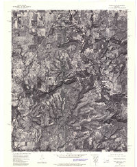
(14)- 1970 Map of Wainwright, 1972 Print
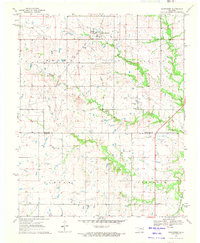 1970 Wainwright1972 Print · USGSCentral Muskogee County and northern McIntosh County appear in the early seventies as a rural landscape of ranching and energy. Genealogists can trace family names and landmarks like Middleton Cem and the Missouri - Kansas - Texas railroad line.
 - 1970 Map of Council Hill, 1972 Print
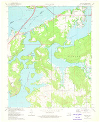
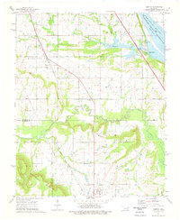
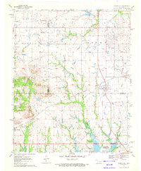 1970 Council Hill1972 Print · USGSCouncil Hill and Hitchita appear at the convergence of three Oklahoma counties in the early seventies, just as the regional landscape was being reshaped. Genealogists and researchers can trace family sites at the Council Hill Cem, Ridley Cem, and New Hope Ch while exploring the developing shoreline of the Eufaula Reservoir.2 unique versions available
 - 1970 Map of Morris, 1972 Print
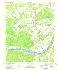
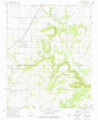
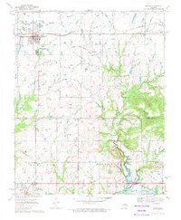 1970 Morris1972 Print · USGSEastern Oklahoma at the start of the 1970s reveals a landscape shaped by petroleum and rail. Genealogists and historians can trace family locations near Morris and Grayson, or locate historic sites like Indian Cem and the Grave Creek Ch.
 - 1971 Map of Canadian, 1972 Print
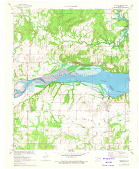
 1971 Canadian1972 Print · USGSThe shorelines of the McIntosh and Pittsburg county line are captured here in the early 1970s as new reservoirs reshaped the land. Researchers can trace family history through sites like Masonic Cem or the rural settlement at Mellette, and follow the path of the Missouri Kansas Texas line.2 unique versions available
 - 1971 Map of Longtown, 1972 Print
 1971 Longtown1972 Print · USGSThe Pittsburg and McIntosh County line was reshaped by the mid-century flooding of the Eufaula Reservoir. Researchers can trace the development of Arrowhead State Park and locate historic sites like Bower Cem and the Longtown settlement.
 - 1971 Map of Indianola, 1973 Print
 1971 Indianola1973 Print · USGSIndianola and the Canadian River valley are captured here in the early seventies as the waters of Eufaula Reservoir reshaped the terrain. Genealogists and historians can trace local family landmarks like Choate Prairie Cem and the Old Railroad Grade.2 unique versions available
 - 1971 Map of Hanna, 1973 Print
 1971 Hanna1973 Print · USGSMcIntosh and Hughes counties are captured here in the early seventies as the local landscape adapted to the new Eufaula Reservoir. Researchers can trace family history at the Vernon Cem or locate rural landmarks like Weogufkee Ch and the Old Railroad Grade.2 unique versions available
 - 1972 Map of Keefeton SE, 1974 Print
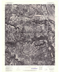 1972 Keefeton SE1974 Print · USGSMuskogee County in the early seventies is documented through detailed aerial photography showing the rural landscape around Keefeton. Researchers can trace the early shoreline of Webbers Falls Reservoir and the terrain of the Rattlesnake Mountains.
 - 1972 Map of Keefeton SW, 1974 Print
 1972 Keefeton SW1974 Print · USGSEastern Oklahoma's rural landscape is captured in the early 1970s, showing the settlement patterns near the historic town of Rentiesville. Researchers can trace the wooded slopes of the Rattlesnake Mountains and field boundaries near Oktaha.
 - 1974 Map of Keefton, 1978 Print
 1974 Keefton1978 Print · USGSThe Muskogee County countryside in the 1970s shows a landscape of established rail corridors and family cemeteries near the Arkansas River. Researchers can trace the roots of small communities like Keefton and McLain or locate Agnew Cem and Elm Grove Ch.
 - 1974 Map of Oktaha, 1978 Print
 1974 Oktaha1978 Print · USGSOklahoma's southern Muskogee County and northern McIntosh County are shown here in the mid-seventies, just as the landscape was beginning to modernize. Researchers can trace the Indian Treaty Boundary and locate historic community sites like Rentiesville, Honey Springs Cem, and the Missouri-Kansas-Texas rail line.
 - 1978 Map of Eufaula, 1979 Print
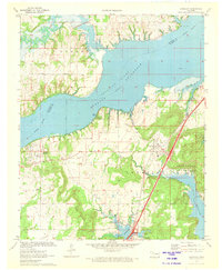
 1978 Eufaula1979 Print · USGSEastern Oklahoma in the late seventies is defined by the sprawling waters of Eufaula Lake and the dense timber of the Sans Bois Mountains. Genealogists and historians can trace the development of towns like Checotah and Stigler or locate legacy sites like the Old R R Grade and Robbers Cave State Park.
 - 1978 Map of Muskogee, 1979 Print
 1978 Muskogee1979 Print · USGSThe confluence of the Arkansas, Verdigris, and Neosho Rivers defines the Muskogee region in the late seventies. Genealogists and historians can trace the footprints of Camp Gruber (Abandoned), the campus of Bacone College, and early aviation at Hatbox Field.
 - 1978 Map of Fort Smith, 1979 Print
 1978 Fort Smith1979 Print · USGSThe Arkansas-Oklahoma borderlands in the late seventies show a landscape shaped by massive river reservoirs and sprawling military reservations. Trace the historic rail lines of the Missouri Pacific RR and locate regional landmarks like Fort Gibson, Tenkiller Ferry Lake, and Barling.2 unique versions available
End of results
Showing maps 1-14 of 14
Top cities of McIntosh County
- Checotah historical maps
- Eufaula historical maps
- Hanna historical maps
- Hitchita historical maps
- Rentiesville historical maps
- Stidham historical maps
Frequently asked questions
- What are the different types of historical maps available for McIntosh County?
- What is the oldest map of McIntosh County?
- Where can I purchase historical maps of McIntosh County for my home or office?
- Where can I download high-res historical maps of McIntosh County?
- Are there historical topographic maps available for McIntosh County?
- Is there historical aerial imagery available for McIntosh County?
- Where are historical maps of McIntosh County sourced from?