1950s Maps of Pittsburg County, Oklahoma
Explore 5 historic maps of Pittsburg County from the 1950s. These maps offer a rare glimpse into what life looked like during the 1950s — showing old roads, neighborhoods, homes, and landmarks that have changed or disappeared over time.
Whether you're researching your family's past, planning a metal detecting trip, or studying how Pittsburg County's landscape evolved across the 1950s, these high-resolution maps are a powerful tool for exploring the history of this region.
- Focus on a specific era: All maps on this page are from the 1950s, giving you a focused view of this time period.
- See what’s changed: Compare century-old streets, trails, and buildings to today's modern landscape using overlays and satellite layers.
- Research with precision: Use these maps for genealogy, historical research, land use analysis, or educational projects.
- View, download, or print: Maps are fully viewable online in high resolution, and can be downloaded or printed for your own records.
Start exploring Pittsburg County's history through authentic maps from the 1950s. This is your window into the past.
Pittsburg County, OK maps
(5)- 1950 Map of Mcalester
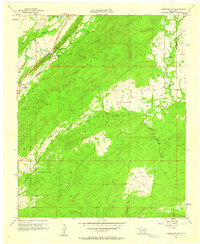
 1950 Mcalester1950 Print · USGSThe Ouachita Mountains and the coal country of Southeast Oklahoma are shown here in the late 1940s. Genealogists and historians can trace the rail-driven growth of McAlester, Wilburton, and Antlers alongside the rugged terrain of Kiamichi Mountain.2 unique versions available
 - 1954 Map of Oklahoma City
 1954 Oklahoma City1954 Print · USGSOklahoma City and its surrounding counties are captured here in the early fifties during a period of significant postwar growth. Researchers can trace the development of the Turner Turnpike and locate aviation hubs like Tinker Field or Will Rogers Field.
 - 1957 Map of Limestone Gap, 1958 Print
 1957 Limestone Gap1958 Print · USGSAtoka County during the late fifties reveals a landscape defined by the ridgelines of the Choctaw Nation. Genealogists and historians can trace the old rail corridor of the Missouri Kansas Texas through settlements like Chockie, Burg, and Limestone Gap.2 unique versions available
 - 1957 Map of Ardmore, 1968 Print
 1957 Ardmore1968 Print · USGSSouth-central Oklahoma in the late fifties was a landscape of rising reservoir waters and expanding rail lines. Genealogists and historians can trace the foundations of Ardmore and Duncan or locate early recreation sites at Platt National Park and Lake Murray State Park.3 unique versions available
 - 1957 Map of Oklahoma City, 1969 Print
 1957 Oklahoma City1969 Print · USGSCentral Oklahoma is captured here in a period of significant mid-century growth and industrialization. Researchers can trace family roots through numerous rural markers like Memory Lane Cem, New Hope School, and the sprawling grounds of Tinker Air Force Base.3 unique versions available
End of results
Showing maps 1-5 of 5
Top cities of Pittsburg County
- McAlester historical maps
- Krebs historical maps
- Hartshorne historical maps
- Quinton historical maps
- Haileyville historical maps
- Savanna historical maps
See more
Frequently asked questions
- What are the different types of historical maps available for Pittsburg County?
- What is the oldest map of Pittsburg County?
- Where can I purchase historical maps of Pittsburg County for my home or office?
- Where can I download high-res historical maps of Pittsburg County?
- Are there historical topographic maps available for Pittsburg County?
- Is there historical aerial imagery available for Pittsburg County?
- Where are historical maps of Pittsburg County sourced from?