1980s Maps of Frederick, Oklahoma
Explore 4 historic maps of Frederick from the 1980s. These maps offer a rare glimpse into what life looked like during the 1980s — showing old roads, neighborhoods, homes, and landmarks that have changed or disappeared over time.
Whether you're researching your family's past, planning a metal detecting trip, or studying how Frederick's landscape evolved across the 1980s, these high-resolution maps are a powerful tool for exploring the history of this region.
- Focus on a specific era: All maps on this page are from the 1980s, giving you a focused view of this time period.
- See what’s changed: Compare century-old streets, trails, and buildings to today's modern landscape using overlays and satellite layers.
- Research with precision: Use these maps for genealogy, historical research, land use analysis, or educational projects.
- View, download, or print: Maps are fully viewable online in high resolution, and can be downloaded or printed for your own records.
Start exploring Frederick's history through authentic maps from the 1980s. This is your window into the past.
Frederick, OK maps
(4)- 1984 Map of Frederick SE, 1985 Print
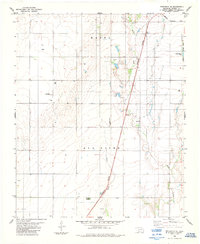 1984 Frederick SE1985 Print · USGSTillman County in the mid-1980s reveals a landscape of petroleum production and rail transport along the Red River border. Researchers can locate the Davidson Cemetery and follow the Burlington Northern line as it passes an Oil Field.
 - 1984 Map of Frederick, 1985 Print
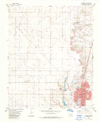 1984 Frederick1985 Print · USGSThe rail-driven hub of Frederick is captured here during the mid-eighties, showing the town's full street grid and civic layout. Local historians can trace the paths of the Missouri Kansas Texas railroad and locate the Frederick Cem or Central Sch.
 - 1985 Map of Burkburnett, 1986 Print
 1985 Burkburnett1986 Print · USGSThe Red River valley and North Texas oil fields are captured here in the mid-eighties, showing the vital connection between military hubs and rail towns. Researchers can trace the path of the Missouri Kansas Texas railroad through Burkburnett or locate Waurika Lake and Sheppard Air Force Base.2 unique versions available
 - 1986 Map of Vernon
 1986 Vernon1986 Print · USGSNorth Texas and Southern Oklahoma meet along the river in the mid-1980s, revealing a landscape defined by ranching, oil production, and rail transport. Researchers can locate distinct landmarks such as Medicine Mound, the Conley Oil Field, and the community of Punkin Center.
End of results
Showing maps 1-4 of 4
Top cities near Frederick
Frequently asked questions
- What are the different types of historical maps available for Frederick?
- What is the oldest map of Frederick?
- Where can I purchase historical maps of Frederick for my home or office?
- Where can I download high-res historical maps of Frederick?
- Are there historical topographic maps available for Frederick?
- Is there historical aerial imagery available for Frederick?
- Where are historical maps of Frederick sourced from?