1940s Maps of Astoria, Oregon
Explore 3 historic maps of Astoria from the 1940s. These maps offer a rare glimpse into what life looked like during the 1940s — showing old roads, neighborhoods, homes, and landmarks that have changed or disappeared over time.
Whether you're researching your family's past, planning a metal detecting trip, or studying how Astoria's landscape evolved across the 1940s, these high-resolution maps are a powerful tool for exploring the history of this region.
- Focus on a specific era: All maps on this page are from the 1940s, giving you a focused view of this time period.
- See what’s changed: Compare century-old streets, trails, and buildings to today's modern landscape using overlays and satellite layers.
- Research with precision: Use these maps for genealogy, historical research, land use analysis, or educational projects.
- View, download, or print: Maps are fully viewable online in high resolution, and can be downloaded or printed for your own records.
Start exploring Astoria's history through authentic maps from the 1940s. This is your window into the past.
Astoria, OR maps
(3)- 1940 Map of Svensen
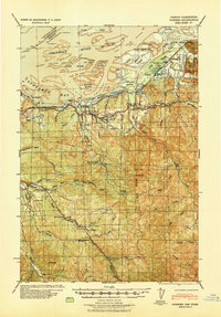 1940 Svensen1940 Print · USGSCoastal Clatsop County at the start of the 1940s reveals a complex network of river channels and small rail-side settlements. Genealogists and historians can locate old landmarks like Ivy Station, the CCC Camp, and several rural schoolhouses including Olney Sch.
 - 1949 Map of Astoria
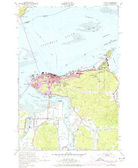 1949 Astoria1949 Print · USGSThe mouth of the Columbia River comes to life in this mid-century survey, showing the busy maritime hub of Astoria and its surrounding riverbanks. Genealogists and historians can trace the development of Navy Heights, find the Astor Column, and locate early schools like School No 26.4 unique versions available
 - 1949 Map of Cathlamet Bay, 1955 Print
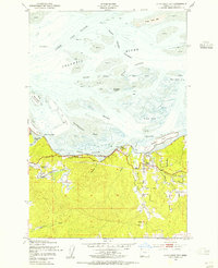 1949 Cathlamet Bay1955 Print · USGSClatsop County shorelines and the Columbia River islands appear here during the late 1940s. Researchers can trace the rail-and-road corridor through Svensen, locate family sites near Fern Hill Sch, and see early land reclamation at Mott Island.4 unique versions available
End of results
Showing maps 1-3 of 3
Top cities near Astoria
Top neighborhoods of Astoria
- Doughboy historical maps
- South Slope historical maps
- Tongue Point Village historical maps
- Uniontown historical maps
- Tide Point historical maps
- Uppertown historical maps
See more
Frequently asked questions
- What are the different types of historical maps available for Astoria?
- What is the oldest map of Astoria?
- Where can I purchase historical maps of Astoria for my home or office?
- Where can I download high-res historical maps of Astoria?
- Are there historical topographic maps available for Astoria?
- Is there historical aerial imagery available for Astoria?
- Where are historical maps of Astoria sourced from?