1950s Maps of Coos County, Oregon
Explore 19 historic maps of Coos County from the 1950s. These maps offer a rare glimpse into what life looked like during the 1950s — showing old roads, neighborhoods, homes, and landmarks that have changed or disappeared over time.
Whether you're researching your family's past, planning a metal detecting trip, or studying how Coos County's landscape evolved across the 1950s, these high-resolution maps are a powerful tool for exploring the history of this region.
- Focus on a specific era: All maps on this page are from the 1950s, giving you a focused view of this time period.
- See what’s changed: Compare century-old streets, trails, and buildings to today's modern landscape using overlays and satellite layers.
- Research with precision: Use these maps for genealogy, historical research, land use analysis, or educational projects.
- View, download, or print: Maps are fully viewable online in high resolution, and can be downloaded or printed for your own records.
Start exploring Coos County's history through authentic maps from the 1950s. This is your window into the past.
Coos County, OR maps
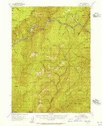
(19)- 1954 Map of Coos Bay
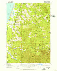
 1954 Coos Bay1954 Print · USGSCoastal Oregon at mid-century shows a landscape of timber and tides, from the river ports to the edge of the Pacific. Researchers can trace family roots through coastal schools like Beachview School or follow the Southern Pacific RR through Reedsport and Coos Bay.
 - 1954 Map of Bone Mountain, 1955 Print
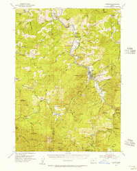
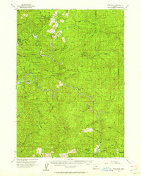
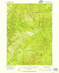 1954 Bone Mountain1955 Print · USGSThe timber-rich backcountry of Coos and Douglas counties is seen here in the mid-fifties, during the height of the region's logging era. Researchers can trace old forest outposts and industry landmarks like Camp No 2, the Wooden Rock Guard Sta, and the Fuller Mine.2 unique versions available
 - 1954 Map of Marial, 1956 Print
 1954 Marial1956 Print · USGSThe Rogue River canyon in the 1950s is shown here as a remote landscape of forest camps and river bars. Genealogists and historians can trace old trails and lookouts including Dutch Henry Trail, Marial, and Paradise Bar Landing Field.4 unique versions available
 - 1954 Map of Cape Blanco, 1956 Print
 1954 Cape Blanco1956 Print · USGSCoastal Curry County at the height of the 1950s shows a landscape defined by its maritime hazards and river-mouth agriculture. Researchers can trace the layout of the Cranberry Bogs, the grounds of Cape Blanco State Park, and dozens of named offshore rocks like Best Rock and Seal Rock.3 unique versions available
 - 1954 Map of Agness, 1956 Print
 1954 Agness1956 Print · USGSCoastal Oregon's wild interior is captured here in the mid-fifties as river life and forest management shaped the landscape. Genealogists and researchers can trace the early footprints of Agness, Illahe, and Oak Flat, alongside remote landmarks like Bonanza Basin and the local Cemetery.3 unique versions available
 - 1954 Map of Powers, 1956 Print
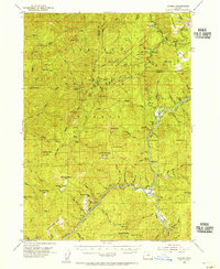
 1954 Powers1956 Print · USGSThe timber and ranching country of Coos and Curry Counties comes alive in the mid-fifties, centered on the railroad town of Powers. Researchers can trace old family holdings like Dement Ranch, locate the Etelka Sch, and follow the Southern Pacific line to Gaylord Siding.3 unique versions available
 - 1954 Map of Langlois, 1956 Print
 1954 Langlois1956 Print · USGSCoastal Curry County in the mid-fifties is a landscape of cranberry agriculture and rugged timberlands. Researchers can trace the early highway settlements of Denmark and Langlois or locate coastal landmarks like Floras Lake and the Cranberry Bogs.3 unique versions available
 - 1955 Map of Camas Valley, 1957 Print
 1955 Camas Valley1957 Print · USGSDouglas County’s timber country comes into focus in the mid-1950s, showing the networks of water and road that sustained these mountain communities. Researchers can locate early family burial sites like Noah Cem and Patterson Cemetery or trace the early paths of Wagon Road and Callahan Rd.3 unique versions available
 - 1955 Map of Scottsburg, 1957 Print
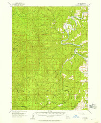
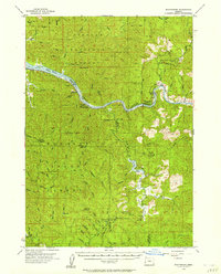 1955 Scottsburg1957 Print · USGSCoastal Oregon's timber and river country is recorded here in the mid-fifties, centered on the historic river landing of Scottsburg. Researchers can trace the early footprints of the Elliott State Forest and locate specific landmarks like Loon Lake, Ash Valley, and Elk Peak.3 unique versions available
 - 1955 Map of Ivers Peak, 1957 Print
 1955 Ivers Peak1957 Print · USGSThe Oregon Coast Range is captured here in the mid-1950s, showing a rugged landscape of state parks and timber outposts. Trace the remote Tioga Guard Station, the Coos River Fish Hatchery, and landmarks like Golden Falls.3 unique versions available
 - 1955 Map of Sitkum, 1957 Print
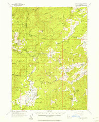
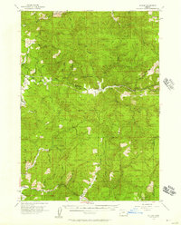 1955 Sitkum1957 Print · USGSThe Oregon backcountry in the mid-1950s was a network of timbered ridges and river-dependent settlements. Researchers can trace the early road systems through Sitkum and Dora, locating fire watch points like Brewster Rock Lookout and Kenyon Lookout.3 unique versions available
 - 1955 Map of Tyee, 1957 Print
 1955 Tyee1957 Print · USGSThe winding Umpqua River and the timbered ridges of Douglas County are captured here in the mid-fifties. Local historians can trace the early riverside settlements of Tyee and Millwood or locate the fire lookouts at Bateman Lookout and Kelly Butte.3 unique versions available
 - 1955 Map of Medford, 1964 Print
 1955 Medford1964 Print · USGSSouthern Oregon's valley towns and high peaks are captured here in the mid-1950s, showing the region before the completion of the modern interstate system. Genealogists and historians can trace the development of timber and mining outposts from Wolf Creek to Butte Falls and the early roads to Crater Lake.3 unique versions available
 - 1956 Map of Reedsport
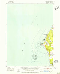
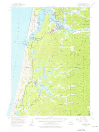 1956 Reedsport1956 Print · USGSCoastal Douglas and Coos counties appear here in the mid-fifties, centered on the bustling river-and-rail hub of Reedsport. Researchers can trace the waterfront legacy of Gardiner, locate the North Bend Air Force Station, or explore the lakeside landings at Lakeside and Shutter Landing.3 unique versions available
 - 1957 Map of Medford
 1957 Medford1957 Print · USGSSouthern Oregon during the mid-fifties is captured here as a region of growing valley cities and vast timberlands. Genealogists and historians can trace the rail-and-road corridors connecting Medford, Jacksonville, and Grants Pass to more remote locales like Wolf Creek or Butte Falls.
 - 1958 Map of Medford
 1958 Medford1958 Print · USGSSouthern Oregon's Rogue River valley thrived in the 1950s as a crossroads of rail and road. Researchers can trace the legacy of timber and tourism through Southern Pacific RR lines and landmarks like Crater Lake and Oregon Caves National Monument.
 - 1958 Map of Roseburg, 1960 Print
 1958 Roseburg1960 Print · USGSThe timber valleys and high volcanic peaks of Southern Oregon are captured here in the late fifties. Researchers can trace the Southern Pacific rail line through historic settlements like Cottage Grove, Yoncalla, and Oakridge near the Cascade Range crest.4 unique versions available
 - 1958 Map of Coos Bay, 1974 Print
 1958 Coos Bay1974 Print · USGSThe Southern Oregon coastline at mid-century reveals a bustling maritime and timber economy centered on Coos Bay and North Bend. Researchers can trace the legacy of coastal settlements from Bandon to Brookings, including rail lines of the Southern Pacific RR and the rugged reaches of the Siuslaw National Forest.
 - 1959 Map of Roseburg
 1959 Roseburg1959 Print · USGSThe Umpqua and Willamette valleys meet the high Cascades in this late-fifties study of Southern Oregon's timber and rail corridors. Genealogists and researchers can trace the Southern Pacific RR through historic towns like Roseburg, Yoncalla, and Cottage Grove.
End of results
Showing maps 1-19 of 19
Top cities of Coos County
- Coos Bay historical maps
- North Bend historical maps
- Coquille historical maps
- Bandon historical maps
- Myrtle Point historical maps
- Barview historical maps
See more
Frequently asked questions
- What are the different types of historical maps available for Coos County?
- What is the oldest map of Coos County?
- Where can I purchase historical maps of Coos County for my home or office?
- Where can I download high-res historical maps of Coos County?
- Are there historical topographic maps available for Coos County?
- Is there historical aerial imagery available for Coos County?
- Where are historical maps of Coos County sourced from?