1980s Maps of Coos County, Oregon
Explore 16 historic maps of Coos County from the 1980s. These maps offer a rare glimpse into what life looked like during the 1980s — showing old roads, neighborhoods, homes, and landmarks that have changed or disappeared over time.
Whether you're researching your family's past, planning a metal detecting trip, or studying how Coos County's landscape evolved across the 1980s, these high-resolution maps are a powerful tool for exploring the history of this region.
- Focus on a specific era: All maps on this page are from the 1980s, giving you a focused view of this time period.
- See what’s changed: Compare century-old streets, trails, and buildings to today's modern landscape using overlays and satellite layers.
- Research with precision: Use these maps for genealogy, historical research, land use analysis, or educational projects.
- View, download, or print: Maps are fully viewable online in high resolution, and can be downloaded or printed for your own records.
Start exploring Coos County's history through authentic maps from the 1980s. This is your window into the past.
Coos County, OR maps
(16)- 1980 Map of Reedsport, 1987 Print
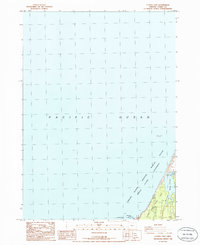
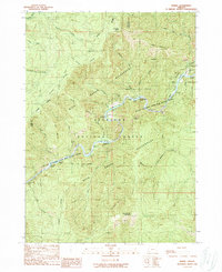
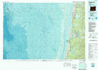 1980 Reedsport1987 Print · USGSThe Oregon coast at the dawn of the 1980s reveals a landscape defined by timber, tourism, and the shifting sands of the Oregon Dunes. Local historians can trace the rail-and-river economy through Reedsport, the historic timber town of Gardiner, and the lakeside community of Lakeside.
 - 1985 Map of Trail Butte
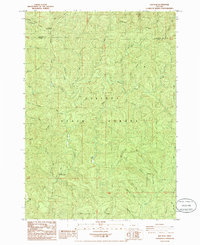
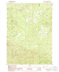
 1985 Trail Butte1985 Print · USGSThe coastal hills of Coos and Douglas counties are mapped here in the mid-1980s, showcasing the dense timberlands and lake systems. Researchers can trace the fingers of North Tenmile Lake and locate old sites like Camp Easter Seal and the Hatchery.
 - 1985 Map of Lakeside
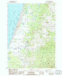
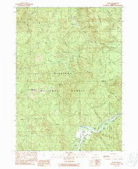
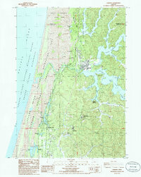 1985 Lakeside1985 Print · USGSThe Oregon coast at the mid-eighties shows a landscape of deep freshwater lakes and massive dunes. Genealogists and researchers can trace the growth of Lakeside and Saunders Lake, or locate the cemetery, US Naval Reservation, and old campgrounds.
 - 1985 Map of Loon Lake
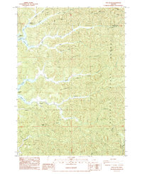
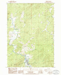
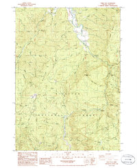
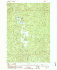 1985 Loon Lake1985 Print · USGSLoon Lake and the Elliott State Forest are shown here in the mid-1980s, highlighting the balance of timberland and recreation. You can trace the settlement at Ash, find the East Shore Recreation Site, and locate distinctive landmarks like Beehive Rock and Michigan Pass.
 - 1985 Map of Elk Peak
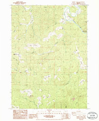
 1985 Elk Peak1985 Print · USGSCoastal Oregon's timberlands are mapped in detail during the mid-1980s, centered on the high ridges of the Elliott State Forest. Researchers can trace the drainages of the West Fork Millicoma River and locate landmarks like Dean Mountain and the Radio Tower at Elk Peak.
 - 1985 Map of Calf Ranch Mtn, 1986 Print
 1985 Calf Ranch Mtn1986 Print · USGSCoastal range highlands in Curry County are captured here in the 1980s, showing a rugged network of timberlands and creek drainages. Genealogists and researchers can locate remote landmarks like Camp Fir Croft, White Elephant Bridge, and Calf Ranch Mtn.
 - 1986 Map of Langlois
 1986 Langlois1986 Print · USGSCoastal Curry County at the mid-eighties shows a unique landscape of maritime wilderness and specialized cranberry farming. Researchers can trace family roots at Denmark Cem or explore the rural layout of Langlois and Denmark near the New River.
 - 1986 Map of Powers
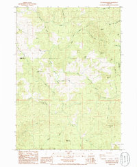
 1986 Powers1986 Print · USGSCoos County's timber and river country is captured here in the mid-1980s, centered on the community of Powers. Genealogists and local historians can trace family sites at Myrtle Creek Cem, locate the Ranger Station, or follow the Railroad Grade along the river.
 - 1986 Map of Floras Lake
 1986 Floras Lake1986 Print · USGSCoastal Curry County in the mid-eighties shows a landscape of protected wilderness and shoreline recreation. Researchers can trace the boundaries of Floras Lake State Park or locate the Boise Cascade County Park near the edge of Floras Lake.
 - 1986 Map of Barklow Mountain
 1986 Barklow Mountain1986 Print · USGSRemote ranching outposts and timber ridges define this part of the Siskiyou National Forest in the 1980s. Genealogists and historians can locate early high-country sites like Dement Ranch, a secluded Cem near Huckleberry Knoll, and Calf Ranch Prairie.
 - 1986 Map of China Flat
 1986 China Flat1986 Print · USGSCoos County's timber and river country is captured in the 1980s as it remains a hub of national forest activity. Trace the drainages of the South Fork Coquille River and find landmarks like China Flat, Orchard Park, and the Powers State Airport.
 - 1986 Map of Dement Creek
 1986 Dement Creek1986 Print · USGSCoastal Oregon timber and river country are mapped in the mid-1980s at the junction of Coos and Curry counties. Genealogists and hikers can locate the Dement Cemetery and trace old landmarks like Bone Camp, Bills Prairie, and Butler.
 - 1989 Map of Ophir Mountain
 1989 Ophir Mountain1989 Print · USGSThe mountain wilderness of the Coos and Curry County line is captured here in the late 1980s. Local researchers can trace old forest outposts and mining traces like McCurdy Camp, Laird Lake Campground, and the MINE at Bonanza Basin.
 - 1989 Map of Marial
 1989 Marial1989 Print · USGSThe Rogue River canyon in the late eighties remained a wild corridor of whitewater and steep ridges. You can trace the path of the Rogue River National Scenic Trail past Marial and the Rogue River Ranch, or locate rapids like Devils Stairs.
 - 1989 Map of Illahe
 1989 Illahe1989 Print · USGSThe remote forest lands along the Coos and Curry county line are captured in the late eighties as timber and wilderness management shaped the region. Genealogists and researchers can trace the vicinity of Illahe or locate early recreation spots like Daphne Grove Campground and the Coquille River Falls.
 - 1989 Map of Canyonville
 1989 Canyonville1989 Print · USGSSouthern Oregon's timber and rail corridors come into focus during the late eighties as communities like Canyonville and Riddle anchor the local economy. Researchers can trace the path of the Southern Pacific Railroad and locate early settlements such as Placer, Leland, and Sunny Valley.2 unique versions available
End of results
Showing maps 1-16 of 16
Top cities of Coos County
- Coos Bay historical maps
- North Bend historical maps
- Coquille historical maps
- Bandon historical maps
- Myrtle Point historical maps
- Barview historical maps
See more
Frequently asked questions
- What are the different types of historical maps available for Coos County?
- What is the oldest map of Coos County?
- Where can I purchase historical maps of Coos County for my home or office?
- Where can I download high-res historical maps of Coos County?
- Are there historical topographic maps available for Coos County?
- Is there historical aerial imagery available for Coos County?
- Where are historical maps of Coos County sourced from?