1970s Maps of Coos County, Oregon
Explore 17 historic maps of Coos County from the 1970s. These maps offer a rare glimpse into what life looked like during the 1970s — showing old roads, neighborhoods, homes, and landmarks that have changed or disappeared over time.
Whether you're researching your family's past, planning a metal detecting trip, or studying how Coos County's landscape evolved across the 1970s, these high-resolution maps are a powerful tool for exploring the history of this region.
- Focus on a specific era: All maps on this page are from the 1970s, giving you a focused view of this time period.
- See what’s changed: Compare century-old streets, trails, and buildings to today's modern landscape using overlays and satellite layers.
- Research with precision: Use these maps for genealogy, historical research, land use analysis, or educational projects.
- View, download, or print: Maps are fully viewable online in high resolution, and can be downloaded or printed for your own records.
Start exploring Coos County's history through authentic maps from the 1970s. This is your window into the past.
Coos County, OR maps
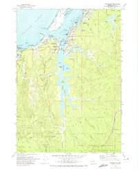
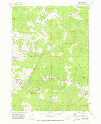
(17)- 1970 Map of Bandon, 1973 Print
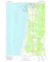 1970 Bandon1973 Print · USGSBandon and the Coos County coastline are captured here in the early seventies, a time when the local economy balanced maritime operations with extensive cranberry farming. Genealogists and local historians can locate the Knights of Pythias Cem, the Millard Sch, and family-named landmarks like Bradley Lake.2 unique versions available
 - 1970 Map of Bullards, 1973 Print
 1970 Bullards1973 Print · USGSThe Oregon coast at the start of the 1970s reveals a unique landscape where the Coquille River winds past Cranberry Bogs and the small community of Bullards. Researchers can trace local landmarks like Bullards Cem, the Bullards Bridge, and the shifting Sand Dunes near Whisky Run.
 - 1970 Map of Empire, 1973 Print
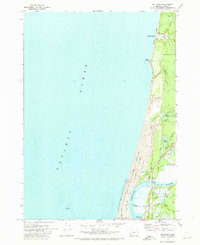
 1970 Empire1973 Print · USGSThe Coos Bay shoreline at the start of the 1970s reveals a landscape defined by industrial expansion and coastal preservation. Researchers can trace the layout of the Empire settlement, the campus of Southwestern Oregon Community College, and the sprawling North Spit.2 unique versions available
 - 1970 Map of Cape Arago, 1973 Print
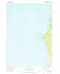 1970 Cape Arago1973 Print · USGSThe Coos County coastline in the early 1970s reveals a rugged landscape of maritime navigation and nascent state parks. Researchers can trace the layout of the Coast Guard Reservation at Gregory Point or locate the remote Sacchi Beach along the Seven Devils ridge.2 unique versions available
 - 1970 Map of Charleston, 1974 Print
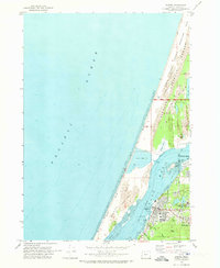
 1970 Charleston1974 Print · USGSThe Oregon coast at Coos Bay comes alive in this 1970s survey, detailing a landscape defined by maritime research and military installations. Trace the coastal developments from the Cape Arago Lighthouse to the Cranberry Bogs and the US Naval Facility.
 - 1971 Map of Coquille, 1973 Print
 1971 Coquille1973 Print · USGSThe Coquille River valley in the early seventies shows a bustling timber and rail hub surrounded by the Coos County Forest. Genealogists can locate family landmarks like Montgomerys Cabin, St James Ch, and the Myrtle Crest Memorial Gardens (Cem).
 - 1971 Map of Daniels Creek, 1973 Print
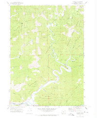
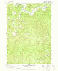 1971 Daniels Creek1973 Print · USGSCoastal Oregon timber country is documented here in the early seventies, centered on the divide between the Coos and Coquille river systems. Local historians can trace the geography of logging outposts and early schools like Dellwood and the Coos River Sch along the South Fork Coos River.
 - 1971 Map of Riverton, 1973 Print
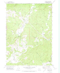
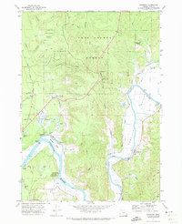 1971 Riverton1973 Print · USGSCoastal Coos County in the early seventies centered on the river-and-slough economy of the Coquille River. Researchers can trace old family burial sites at Hultin Cem or the Kronenberg Cem, and locate former settlements like Beaver Hill and Parkersburg.2 unique versions available
 - 1971 Map of Bridge, 1973 Print
 1971 Bridge1973 Print · USGSCoos County river valleys thrived in the early seventies at the meeting of the three forks of the Coquille. Researchers can trace the timber and transit history of Gravel Ford and Bridge via the Logging Railroad, Gravel Ford Cem, and the Aqueduct.
 - 1971 Map of Myrtle Point, 1973 Print
 1971 Myrtle Point1973 Print · USGSCoastal Oregon timber country and river valleys are documented here in the early seventies. Genealogists can trace family roots through several rural burial sites like Upper Fishtrap Cem and Warner Cem, or locate landmarks such as the County Fairgrounds.
 - 1971 Map of Mc Kinley, 1973 Print
 1971 Mc Kinley1973 Print · USGSCoastal Oregon's Coquille River drainage comes to life in this early 1970s survey. Historians can trace the winding river crossings at Lone Pine Bridge and Fox Bridge, or locate local landmarks like the Pleasant Hill School and Fairview Cem.
 - 1971 Map of Bill Peak, 1973 Print
 1971 Bill Peak1973 Print · USGSThe Coos County backcountry near the Coquille River comes into focus in the early seventies, showing a landscape defined by timber, water, and early agriculture. Researchers can trace the layout of Cranberry Bogs, locate the settlement of Winterville, and follow historic routes like Morrison Road and the Ferry crossing.2 unique versions available
 - 1971 Map of Allegany, 1973 Print
 1971 Allegany1973 Print · USGSCoastal Oregon timber country comes alive in this early 1970s survey of the Millicoma River system and the Elliott State Forest. Genealogists and historians can trace local landmarks like Allegany Sch, the South Fork Cem, and the Landrith Bridge.
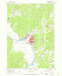
 - 1971 Map of Coos Bay, 1974 Print
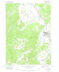
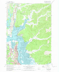
 1971 Coos Bay1974 Print · USGSThe Coos Bay shoreline in the early seventies was a bustling network of timber shipping, rail transport, and mining. Genealogists and local historians can trace family-named sites and old communities like Libby, Southport, and the Sumner Pioneer Cem.2 unique versions available
 - 1971 Map of North Bend, 1974 Print
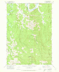
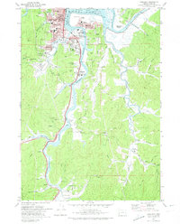
 1971 North Bend1974 Print · USGSThe Coos Bay shoreline was a hub of industrial and timber activity in the early seventies, centered on the growing port cities. Genealogists and researchers can trace local neighborhoods and schools like Sunny Hill Sch, the historic McCullough Bridge, and rural corners such as Cooston.
 - 1979 Map of Roseburg
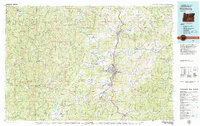 1979 Roseburg1979 Print · USGSThe Umpqua River valley and the foothills of the Coast Range are captured here during a period of active timber and mineral production in the late seventies. Researchers can trace the paths of the Southern Pacific and the Bonanza Mine alongside small settlements like Coles Valley and Nonpareil.
 - 1979 Map of Cottage Grove
 1979 Cottage Grove1979 Print · USGSThe Oregon timber and rail corridors of the late seventies are documented here, centered on the Coast Fork Willamette River and the growing hub of Cottage Grove. Researchers can trace the path of the Southern Pacific railroad as it connects small stations like Divide, Saginaw, and Yoncalla.2 unique versions available
End of results
Showing maps 1-17 of 17
Top cities of Coos County
- Coos Bay historical maps
- North Bend historical maps
- Coquille historical maps
- Bandon historical maps
- Myrtle Point historical maps
- Barview historical maps
See more
Frequently asked questions
- What are the different types of historical maps available for Coos County?
- What is the oldest map of Coos County?
- Where can I purchase historical maps of Coos County for my home or office?
- Where can I download high-res historical maps of Coos County?
- Are there historical topographic maps available for Coos County?
- Is there historical aerial imagery available for Coos County?
- Where are historical maps of Coos County sourced from?