1970s Maps of Myrtle Point, Oregon
Explore 2 historic maps of Myrtle Point from the 1970s. These maps offer a rare glimpse into what life looked like during the 1970s — showing old roads, neighborhoods, homes, and landmarks that have changed or disappeared over time.
Whether you're researching your family's past, planning a metal detecting trip, or studying how Myrtle Point's landscape evolved across the 1970s, these high-resolution maps are a powerful tool for exploring the history of this region.
- Focus on a specific era: All maps on this page are from the 1970s, giving you a focused view of this time period.
- See what’s changed: Compare century-old streets, trails, and buildings to today's modern landscape using overlays and satellite layers.
- Research with precision: Use these maps for genealogy, historical research, land use analysis, or educational projects.
- View, download, or print: Maps are fully viewable online in high resolution, and can be downloaded or printed for your own records.
Start exploring Myrtle Point's history through authentic maps from the 1970s. This is your window into the past.
Myrtle Point, OR maps
(2)- 1971 Map of Bridge, 1973 Print
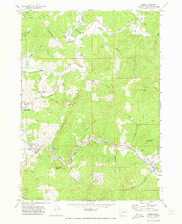 1971 Bridge1973 Print · USGSCoos County river valleys thrived in the early seventies at the meeting of the three forks of the Coquille. Researchers can trace the timber and transit history of Gravel Ford and Bridge via the Logging Railroad, Gravel Ford Cem, and the Aqueduct.
 - 1971 Map of Myrtle Point, 1973 Print
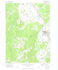 1971 Myrtle Point1973 Print · USGSCoastal Oregon timber country and river valleys are documented here in the early seventies. Genealogists can trace family roots through several rural burial sites like Upper Fishtrap Cem and Warner Cem, or locate landmarks such as the County Fairgrounds.
End of results
Showing maps 1-2 of 2
Top cities near Myrtle Point
Frequently asked questions
- What are the different types of historical maps available for Myrtle Point?
- What is the oldest map of Myrtle Point?
- Where can I purchase historical maps of Myrtle Point for my home or office?
- Where can I download high-res historical maps of Myrtle Point?
- Are there historical topographic maps available for Myrtle Point?
- Is there historical aerial imagery available for Myrtle Point?
- Where are historical maps of Myrtle Point sourced from?