Old Maps of Illahe, Oregon for Hiking & Exploration
Hike through history with 13 historic maps of Illahe. Explore old trails, ghost towns, and forgotten backroads — perfect for outdoor adventurers and local explorers.
- Rediscover forgotten places: Map out old mining camps, roads, and footpaths that no longer exist on modern maps.
- Layer with modern tools: Combine with LiDAR or satellite views to plan hikes through historical terrain.
- Made for exploration: Popular among hikers, overlanders, and local history lovers.
Use these maps to find adventure and explore the hidden past of Illahe.
Illahe, OR maps
(13)- 1899 Map of Port Orford
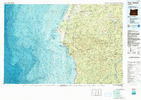
 1899 Port Orford1899 Print · USGSThe Oregon coast at the end of the nineteenth century was a frontier of maritime trade and rugged interior river settlements. Trace early coastal geography from Cape Blanco to Port Orford, and find isolated communities like Agness and Denmark.
 - 1903 Map of Port Orford
 1903 Port Orford1903 Print · USGSCoastal Curry County at the start of the twentieth century was a landscape of remote mountain outposts and rugged river valleys. Genealogists and historians can trace early settlements like Illahe, Agness, and Frankport, or locate landmarks such as Mountain Well and Floras Lake.7 unique versions available
 - 1954 Map of Coos Bay
 1954 Coos Bay1954 Print · USGSCoastal Oregon at mid-century shows a landscape of timber and tides, from the river ports to the edge of the Pacific. Researchers can trace family roots through coastal schools like Beachview School or follow the Southern Pacific RR through Reedsport and Coos Bay.
 - 1954 Map of Agness, 1956 Print
 1954 Agness1956 Print · USGSCoastal Oregon's wild interior is captured here in the mid-fifties as river life and forest management shaped the landscape. Genealogists and researchers can trace the early footprints of Agness, Illahe, and Oak Flat, alongside remote landmarks like Bonanza Basin and the local Cemetery.3 unique versions available
 - 1958 Map of Coos Bay, 1974 Print
 1958 Coos Bay1974 Print · USGSThe Southern Oregon coastline at mid-century reveals a bustling maritime and timber economy centered on Coos Bay and North Bend. Researchers can trace the legacy of coastal settlements from Bandon to Brookings, including rail lines of the Southern Pacific RR and the rugged reaches of the Siuslaw National Forest.
 - 1962 Map of Coos Bay
 1962 Coos Bay1962 Print · USGSThe Oregon coast at the end of the fifties reveals a landscape of timber ports and fishing villages connected by U.S. Highway 101. Researchers can trace the rail infrastructure of the Southern Pacific RR and locate early settlements from Florence down to Brookings.2 unique versions available
 - 1989 Map of Illahe
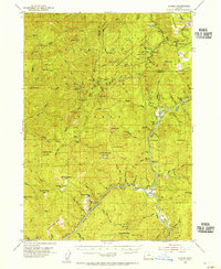
 1989 Illahe1989 Print · USGSThe remote forest lands along the Coos and Curry county line are captured in the late eighties as timber and wilderness management shaped the region. Genealogists and researchers can trace the vicinity of Illahe or locate early recreation spots like Daphne Grove Campground and the Coquille River Falls.
 - 1992 Map of Port Orford, 1993 Print
 1992 Port Orford1993 Print · USGSThe southern Oregon coast and the coastal ranges of the early nineties are captured here in both topographic and bathymetric detail. Researchers can trace landforms from the reefs of Oregon Islands to inland landmarks like Bingham Mountain and Albert H Powers Memorial State Park.
 - 1998 Map of Illahe, 2001 Print
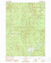
 1998 Illahe2001 Print · USGSCoastal Oregon mountain terrain and the wild river corridor are documented here in the late nineties. Explore the river-bound community of Illahe and trace historic forest sites like Brewery Hole, Agness Pass, and the Cableway.
 - 2011 Map of Illahe, 2011 Print
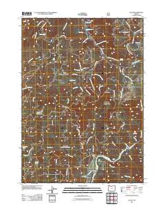 2011 Illahe2011 Print · USGSCovers Illahe, including Coos County, Curry County, and other nearby areas
 - 2017 Map of Illahe, 2017 Print
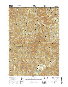 2017 Illahe2017 Print · USGSCovers Illahe, including Coos County, Curry County, and other nearby areas
 - 2020 Map of Illahe, 2020 Print
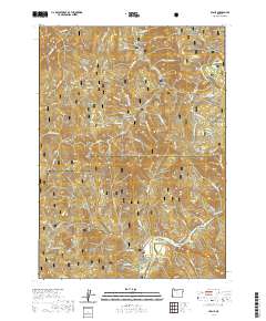 2020 Illahe2020 Print · USGSCovers Illahe, including Coos County, Curry County, and other nearby areas
 - 2023 Map of Illahe, 2023 Print
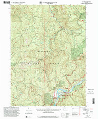
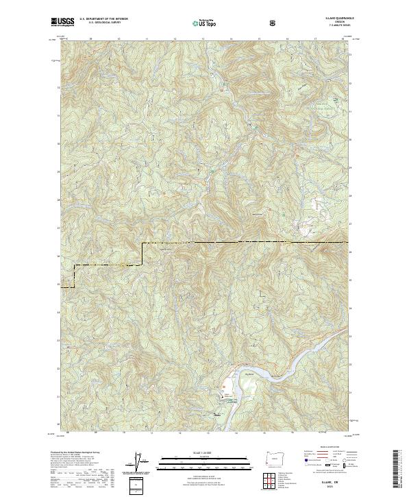 2023 Illahe2023 Print · USGSCoastal Oregon mountain life centers on the Rogue River corridor during the early twenty-first century. Genealogists and hikers can locate the Illahe Cemetery, trace the Panther Ridge Trail, and find remote landmarks like Foster Bar.
End of results
Showing maps 1-13 of 13
Frequently asked questions
- What are the different types of historical maps available for Illahe?
- What is the oldest map of Illahe?
- Where can I purchase historical maps of Illahe for my home or office?
- Where can I download high-res historical maps of Illahe?
- Are there historical topographic maps available for Illahe?
- Is there historical aerial imagery available for Illahe?
- Where are historical maps of Illahe sourced from?