1940s Maps of Bedford County, Pennsylvania
Explore 7 historic maps of Bedford County from the 1940s. These maps offer a rare glimpse into what life looked like during the 1940s — showing old roads, neighborhoods, homes, and landmarks that have changed or disappeared over time.
Whether you're researching your family's past, planning a metal detecting trip, or studying how Bedford County's landscape evolved across the 1940s, these high-resolution maps are a powerful tool for exploring the history of this region.
- Focus on a specific era: All maps on this page are from the 1940s, giving you a focused view of this time period.
- See what’s changed: Compare century-old streets, trails, and buildings to today's modern landscape using overlays and satellite layers.
- Research with precision: Use these maps for genealogy, historical research, land use analysis, or educational projects.
- View, download, or print: Maps are fully viewable online in high resolution, and can be downloaded or printed for your own records.
Start exploring Bedford County's history through authentic maps from the 1940s. This is your window into the past.
Bedford County, PA maps
(7)- 1944 Map of Hyndman
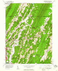
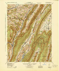 1944 Hyndman1944 Print · USGSBedford County in the mid-1940s is defined by its strategic mountain gaps and the busy rail corridors of Hyndman and Buffalo Mills. Researchers can trace the early Pennsylvania Turnpike or locate vanished landmarks like Bedford Valley P O and James Ch.
 - 1944 Map of Windber
 1944 Windber1944 Print · USGSSomerset County's coal and rail corridors are captured here during the 1940s, showing the region's industrial peak. Genealogists can locate family landmarks like Kaufman Ch, Stoystown Sta, and numerous country schools such as Breastwork Sch.
 - 1944 Map of Berlin
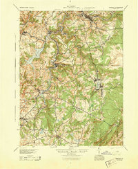
 1944 Berlin1944 Print · USGSSomerset County was undergoing a major transformation in the 1940s as the Pennsylvania Turnpike and its Allegheny Tunnel modernised the landscape. Researchers can trace rural family roots at sites like Sandy Hollow Sch, Lebanon Ch, and old operations like the Salco Mines.
 - 1944 Map of Clearville, 1945 Print
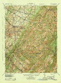
 1944 Clearville1945 Print · USGSBedford and Fulton Counties are captured here in the mid-1940s, showing a landscape of steep ridges and tight-knit valley settlements. Researchers can locate numerous vanished rural landmarks, from Silver Mills and Mills Store to the Hendershot Cem and Indian Spring Sch.
 - 1948 Map of Cumberland
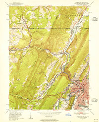
 1948 Cumberland1948 Print · USGSMid-century Appalachia and the Shenandoah Valley are shown in detail, documenting the industrial and transportation hubs of the tri-state area. Genealogists can trace family roots through settlements like Double Tollgate and Bunker Hill or along the Baltimore & Ohio RR.3 unique versions available
 - 1949 Map of Cumberland, 1955 Print
 1949 Cumberland1955 Print · USGSCumberland and the Potomac River valley are shown in detail at mid-century, just as the region's rail and coal infrastructure reached its post-war peak. Local historians can trace the Mason and Dixon Line and locate historic landmarks like Sixmile House and The Narrows.10 unique versions available
 - 1949 Map of Evitts Creek, 1961 Print
 1949 Evitts Creek1961 Print · USGSThe northern edge of Allegany County meets the Mason and Dixon Line in this late-forties survey. Genealogists and local historians can trace rural family sites like Wolfe Mill, Cooks Mills, and the Union Grove Cem nestled between the ridges.3 unique versions available
End of results
Showing maps 1-7 of 7
Top cities of Bedford County
- Bedford historical maps
- Napier Township historical maps
- Everett historical maps
- Hyndman historical maps
- Saxton historical maps
- Pavia Township historical maps
See more
Frequently asked questions
- What are the different types of historical maps available for Bedford County?
- What is the oldest map of Bedford County?
- Where can I purchase historical maps of Bedford County for my home or office?
- Where can I download high-res historical maps of Bedford County?
- Are there historical topographic maps available for Bedford County?
- Is there historical aerial imagery available for Bedford County?
- Where are historical maps of Bedford County sourced from?