1930s Maps of Bedford County, Pennsylvania
Explore 6 historic maps of Bedford County from the 1930s. These maps offer a rare glimpse into what life looked like during the 1930s — showing old roads, neighborhoods, homes, and landmarks that have changed or disappeared over time.
Whether you're researching your family's past, planning a metal detecting trip, or studying how Bedford County's landscape evolved across the 1930s, these high-resolution maps are a powerful tool for exploring the history of this region.
- Focus on a specific era: All maps on this page are from the 1930s, giving you a focused view of this time period.
- See what’s changed: Compare century-old streets, trails, and buildings to today's modern landscape using overlays and satellite layers.
- Research with precision: Use these maps for genealogy, historical research, land use analysis, or educational projects.
- View, download, or print: Maps are fully viewable online in high resolution, and can be downloaded or printed for your own records.
Start exploring Bedford County's history through authentic maps from the 1930s. This is your window into the past.
Bedford County, PA maps
(6)- 1930 Map of Broad Top, 1958 Print
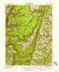 1930 Broad Top1958 Print · USGSThe Broad Top coalfields of the 1930s come alive through this survey of the region's mining towns and mountain ridges. Genealogists can trace family footprints at Bills Place, Miller Sch, and the Garlick Mine along the Huntingdon and Broad Top Mountain RR.2 unique versions available
 - 1931 Map of Clearville
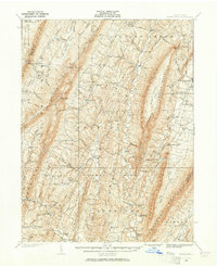
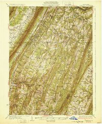 1931 Clearville1931 Print · USGSBedford County at the start of the 1930s shows a landscape of deep ridges and busy valley farms. Genealogists can trace family names through landmarks like Jackson Mills, Chaneysville, and schools such as Barkman Sch or Bittle Sch.3 unique versions available
 - 1931 Map of Hyndman
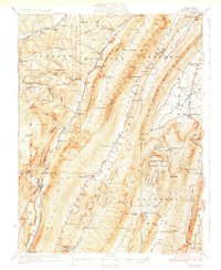 1931 Hyndman1931 Print · USGSHyndman and the surrounding ridges of Bedford County are captured in the late twenties, showing a landscape of tight mountain gaps and railroad hubs. Researchers can trace family-named schoolhouses like Pender Sch, the old Bedford Valley PO, and the Horseshoe Trail.3 unique versions available
 - 1933 Map of Broad Top
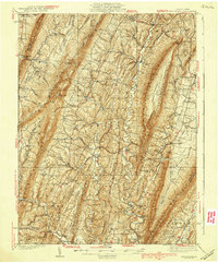
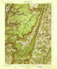 1933 Broad Top1933 Print · USGSBroad Top Mountain and its surrounding coalfields were at a peak of rail-driven activity in the early thirties. Local historians can trace the precise routes of the Huntingdon and Broad Top Mountain RR and locate community landmarks like Wells Tannery and Eagle Foundry Ch.3 unique versions available
 - 1935 Map of Needmore
 1935 Needmore1935 Print · USGSFulton County settlements and ridge-and-valley farmsteads are documented here in the years before the Second World War. Genealogists can trace family names at Wink Cem or locate rural landmarks like Hammans Store, Sipes Mill, and Big Cove Tannery.
 - 1939 Map of Needmore
 1939 Needmore1939 Print · USGSFulton County and the Bedford-Franklin borderlands appear here in the late thirties, showing a rural landscape defined by steep ridges and narrow valleys. Researchers can locate family landmarks like Sipes Mill, Wink Cem, and the Big Cove Tannery.3 unique versions available
End of results
Showing maps 1-6 of 6
Top cities of Bedford County
- Bedford historical maps
- Napier Township historical maps
- Everett historical maps
- Hyndman historical maps
- Saxton historical maps
- Pavia Township historical maps
See more
Frequently asked questions
- What are the different types of historical maps available for Bedford County?
- What is the oldest map of Bedford County?
- Where can I purchase historical maps of Bedford County for my home or office?
- Where can I download high-res historical maps of Bedford County?
- Are there historical topographic maps available for Bedford County?
- Is there historical aerial imagery available for Bedford County?
- Where are historical maps of Bedford County sourced from?