1990s Maps of Bedford County, Pennsylvania
Explore 6 historic maps of Bedford County from the 1990s. These maps offer a rare glimpse into what life looked like during the 1990s — showing old roads, neighborhoods, homes, and landmarks that have changed or disappeared over time.
Whether you're researching your family's past, planning a metal detecting trip, or studying how Bedford County's landscape evolved across the 1990s, these high-resolution maps are a powerful tool for exploring the history of this region.
- Focus on a specific era: All maps on this page are from the 1990s, giving you a focused view of this time period.
- See what’s changed: Compare century-old streets, trails, and buildings to today's modern landscape using overlays and satellite layers.
- Research with precision: Use these maps for genealogy, historical research, land use analysis, or educational projects.
- View, download, or print: Maps are fully viewable online in high resolution, and can be downloaded or printed for your own records.
Start exploring Bedford County's history through authentic maps from the 1990s. This is your window into the past.
Bedford County, PA maps
(6)- 1993 Map of Cumberland, 1999 Print
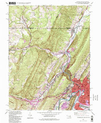 1993 Cumberland1999 Print · USGSCumberland and the Maryland-Pennsylvania borderlands are captured here in the late twentieth century, showing a landscape shaped by the Mason-Dixon Line and deep mountain gaps. Genealogists and historians can trace the C & O Canal, the grounds of the County Home, and legacy rail lines like the Baltimore and Ohio Railroad.
 - 1994 Map of Amaranth, 1997 Print
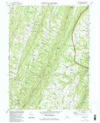 1994 Amaranth1997 Print · USGSThe ridge-and-valley country of the Pennsylvania borderlands remained a mosaic of state forests and small hamlets in the 1990s. Genealogists can locate family landmarks like Silver Mills and Lashley, or trace ancestral ties to Bethel Ch and Jerusalem Ch.
 - 1994 Map of Mench, 1997 Print
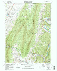
 1994 Mench1997 Print · USGSBedford and Fulton County at the close of the twentieth century show a landscape of deep ridges and rural crossroads. Genealogists can trace family roots through numerous sites like Wesley Chapel, Mattie, and the old structures at Jackson Mills.
 - 1994 Map of Everett East, 1997 Print
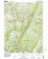
 1994 Everett East1997 Print · USGSMid-century Bedford County comes to life as the Pennsylvania Turnpike begins to shape the valley floor near Everett. Genealogists and local historians can trace the foundations of these communities through the West Providence Sch, Asbury Ch, and the iconic Covered Bridge on Yellow Creek.
 - 1994 Map of Hopewell, 1997 Print
 1994 Hopewell1997 Print · USGSThe valleys and ridges of Bedford County are captured here in the mid-1990s, centered on the river settlements of the Juniata. Researchers can locate dozens of ancestral sites, including Replogle Cem, Smith Sch, and the riverside community of Stonerstown.
 - 1996 Map of Bellegrove, 1999 Print
 1996 Bellegrove1999 Print · USGSThe tri-state border region of Maryland, Pennsylvania, and West Virginia is mapped here during the late nineties. Researchers can trace the winding Sideling Hill Creek and locate historic points like St Pauls Ch and the riverside tracks of CSX Transportation.
End of results
Showing maps 1-6 of 6
Top cities of Bedford County
- Bedford historical maps
- Napier Township historical maps
- Everett historical maps
- Hyndman historical maps
- Saxton historical maps
- Pavia Township historical maps
See more
Frequently asked questions
- What are the different types of historical maps available for Bedford County?
- What is the oldest map of Bedford County?
- Where can I purchase historical maps of Bedford County for my home or office?
- Where can I download high-res historical maps of Bedford County?
- Are there historical topographic maps available for Bedford County?
- Is there historical aerial imagery available for Bedford County?
- Where are historical maps of Bedford County sourced from?