1990s Maps of Northampton Township, Pennsylvania
Explore 4 historic maps of Northampton Township from the 1990s. These maps offer a rare glimpse into what life looked like during the 1990s — showing old roads, neighborhoods, homes, and landmarks that have changed or disappeared over time.
Whether you're researching your family's past, planning a metal detecting trip, or studying how Northampton Township's landscape evolved across the 1990s, these high-resolution maps are a powerful tool for exploring the history of this region.
- Focus on a specific era: All maps on this page are from the 1990s, giving you a focused view of this time period.
- See what’s changed: Compare century-old streets, trails, and buildings to today's modern landscape using overlays and satellite layers.
- Research with precision: Use these maps for genealogy, historical research, land use analysis, or educational projects.
- View, download, or print: Maps are fully viewable online in high resolution, and can be downloaded or printed for your own records.
Start exploring Northampton Township's history through authentic maps from the 1990s. This is your window into the past.
Northampton Township, PA maps
(4)- 1993 Map of Langhorne, 1998 Print
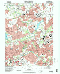 1993 Langhorne1998 Print · USGSBucks County's suburban expansion is fully visible in the 1990s as modern highways weave through historic boroughs and campus grounds. Genealogists can locate family sites at King David Cemetery or Greenwood Cem while tracing the growth of Langhorne and Levittown.
 - 1995 Map of Lambertville, 1998 Print
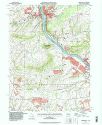 1995 Lambertville1998 Print · USGSThe riverfront culture of the mid-nineties is preserved here as the Delaware River flows between Lambertville and New Hope. Genealogists and local historians can trace rural schoolhouse locations like Fairfield Sch and the grounds of the Mercer County Workhouse.
 - 1999 Map of Hatboro, 2001 Print
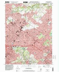 1999 Hatboro2001 Print · USGSThe suburbs of Montgomery and Bucks counties are shown here at the close of the twentieth century as residential growth reached its peak. Researchers can trace the development of Bryn Athyn and Hatboro or locate local landmarks like Union Cem and Neshaminy Creek.
 - 1999 Map of Buckingham, 2001 Print
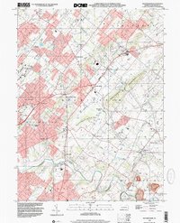 1999 Buckingham2001 Print · USGSBucks County was undergoing steady suburban change at the end of the millennium, yet its historic township patterns remained clear. Researchers can trace family sites near Lahaska, Furlong, and Wycombe, or find community landmarks like the Mt Gilead Ch and Gardenville Sch.
End of results
Showing maps 1-4 of 4
Top cities near Northampton Township
- Philadelphia historical maps
- Trenton historical maps
- Bensalem Township historical maps
- Abington Township historical maps
- Levittown historical maps
- Middletown Township historical maps
See more
Top neighborhoods of Northampton Township
- Saint Leonard historical maps
- Village Shires historical maps
- Grenoble historical maps
- Bridgetown historical maps
- Richboro historical maps
- Breadysville historical maps
See more
Frequently asked questions
- What are the different types of historical maps available for Northampton Township?
- What is the oldest map of Northampton Township?
- Where can I purchase historical maps of Northampton Township for my home or office?
- Where can I download high-res historical maps of Northampton Township?
- Are there historical topographic maps available for Northampton Township?
- Is there historical aerial imagery available for Northampton Township?
- Where are historical maps of Northampton Township sourced from?