1910s Maps of Butler County, Pennsylvania
Explore 6 historic maps of Butler County from the 1910s. These maps offer a rare glimpse into what life looked like during the 1910s — showing old roads, neighborhoods, homes, and landmarks that have changed or disappeared over time.
Whether you're researching your family's past, planning a metal detecting trip, or studying how Butler County's landscape evolved across the 1910s, these high-resolution maps are a powerful tool for exploring the history of this region.
- Focus on a specific era: All maps on this page are from the 1910s, giving you a focused view of this time period.
- See what’s changed: Compare century-old streets, trails, and buildings to today's modern landscape using overlays and satellite layers.
- Research with precision: Use these maps for genealogy, historical research, land use analysis, or educational projects.
- View, download, or print: Maps are fully viewable online in high resolution, and can be downloaded or printed for your own records.
Start exploring Butler County's history through authentic maps from the 1910s. This is your window into the past.
Butler County, PA maps
(6)- 1910 Map of New Kensington
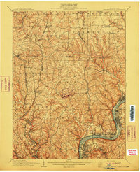 1910 New Kensington1910 Print · USGSThe industrial Allegheny River corridor and its rugged hinterlands come alive in this 1910 survey of the Westmoreland and Butler County borders. Genealogists and historians can trace family roots through labels for Sandy Hill School, Clinton Church, and the settlement at Saxonburg.7 unique versions available
 - 1910 Map of Zelienople
 1910 Zelienople1910 Print · USGSWestern Pennsylvania in the early twentieth century is a landscape of thriving creek-side towns and intersecting rail lines. Genealogists can trace family roots through numerous rural landmarks like McConnells Mill, Zion Church, and the many country schoolhouses including American School.5 unique versions available
 - 1910 Map of Hilliards, 1956 Print
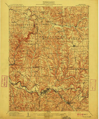
 1910 Hilliards1956 Print · USGSButler and Venango Counties come into focus during this early twentieth-century survey of western Pennsylvania's hill country. Researchers can trace the era's rural infrastructure through dozens of sites like Mechanicsville Wesley PO, Rankin Church, and the Boyer's Annandale Sta.
 - 1911 Map of Butler
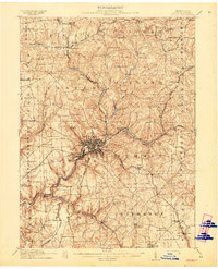 1911 Butler1911 Print · USGSButler emerges as a bustling rail and trolley hub during the first decade of the twentieth century. Genealogists and local historians can trace the paths of the Pittsburg and Butler Electric Railway or locate family homesteads near Frazier Mill and White Church.5 unique versions available
 - 1912 Map of Hilliards
 1912 Hilliards1912 Print · USGSButler and Venango Counties at the height of the rail era are shown here in intricate detail. Genealogists can trace family names across dozens of rural institutions, from Wesley PO and Sutton Mill to the remote Whiskerville.4 unique versions available
 - 1913 Map of Mercer
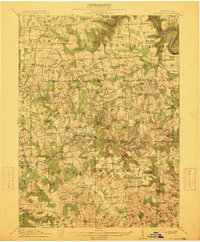
 1913 Mercer1913 Print · USGSMercer and Grove City anchor this early twentieth-century landscape during a period of coal mining and railway expansion. Genealogists can trace family roots through numerous local schools like Bottle Hill School and rural settlements such as Pardoe and Amsterdam.6 unique versions available
End of results
Showing maps 1-6 of 6
Top cities of Butler County
- Cranberry Township historical maps
- Butler historical maps
- Zelienople historical maps
- Slippery Rock historical maps
- Clinton Township historical maps
- Seven Fields historical maps
See more
Frequently asked questions
- What are the different types of historical maps available for Butler County?
- What is the oldest map of Butler County?
- Where can I purchase historical maps of Butler County for my home or office?
- Where can I download high-res historical maps of Butler County?
- Are there historical topographic maps available for Butler County?
- Is there historical aerial imagery available for Butler County?
- Where are historical maps of Butler County sourced from?