1930s Maps of Pike Township, Pennsylvania
Explore 3 historic maps of Pike Township from the 1930s. These maps offer a rare glimpse into what life looked like during the 1930s — showing old roads, neighborhoods, homes, and landmarks that have changed or disappeared over time.
Whether you're researching your family's past, planning a metal detecting trip, or studying how Pike Township's landscape evolved across the 1930s, these high-resolution maps are a powerful tool for exploring the history of this region.
- Focus on a specific era: All maps on this page are from the 1930s, giving you a focused view of this time period.
- See what’s changed: Compare century-old streets, trails, and buildings to today's modern landscape using overlays and satellite layers.
- Research with precision: Use these maps for genealogy, historical research, land use analysis, or educational projects.
- View, download, or print: Maps are fully viewable online in high resolution, and can be downloaded or printed for your own records.
Start exploring Pike Township's history through authentic maps from the 1930s. This is your window into the past.
Pike Township, PA maps
(3)- 1932 Map of Clearfield
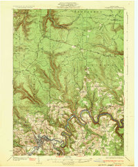 1932 Clearfield1932 Print · USGSClearfield and the West Branch of the Susquehanna are captured here in the early 1930s as a vital hub of rail and river industry. Researchers can trace ancestral locations through numerous rural landmarks like Lecontes Mills, Goshen Ch, and Mt Sinai Sch.4 unique versions available
 - 1932 Map of Penfield
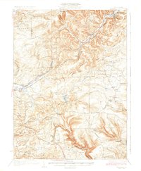 1932 Penfield1932 Print · USGSClearfield County is shown in the early thirties at a time when mountain railroads and forest management defined the region. Local historians can trace the paths of the Pennsylvania RR through Penfield or locate schools such as Coal Hill Sch and Hickory Sch.3 unique versions available
 - 1939 Map of Curwensville, 1952 Print
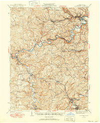 1939 Curwensville1952 Print · USGSClearfield County in the late 1930s is defined by a dense rail-and-river network where the West Branch of the Susquehanna meets Curwensville. Local historians can trace dozens of rural schoolhouses and family burial sites like Friends Cem and Glendale Sch.2 unique versions available
End of results
Showing maps 1-3 of 3
Top cities near Pike Township
- Sandy Township historical maps
- DuBois historical maps
- Clearfield historical maps
- Curwensville historical maps
- Beccaria Township historical maps
- Houtzdale historical maps
See more
Top neighborhoods of Pike Township
Frequently asked questions
- What are the different types of historical maps available for Pike Township?
- What is the oldest map of Pike Township?
- Where can I purchase historical maps of Pike Township for my home or office?
- Where can I download high-res historical maps of Pike Township?
- Are there historical topographic maps available for Pike Township?
- Is there historical aerial imagery available for Pike Township?
- Where are historical maps of Pike Township sourced from?