1990s Maps of Cold Spring Township, Pennsylvania
Explore 4 historic maps of Cold Spring Township from the 1990s. These maps offer a rare glimpse into what life looked like during the 1990s — showing old roads, neighborhoods, homes, and landmarks that have changed or disappeared over time.
Whether you're researching your family's past, planning a metal detecting trip, or studying how Cold Spring Township's landscape evolved across the 1990s, these high-resolution maps are a powerful tool for exploring the history of this region.
- Focus on a specific era: All maps on this page are from the 1990s, giving you a focused view of this time period.
- See what’s changed: Compare century-old streets, trails, and buildings to today's modern landscape using overlays and satellite layers.
- Research with precision: Use these maps for genealogy, historical research, land use analysis, or educational projects.
- View, download, or print: Maps are fully viewable online in high resolution, and can be downloaded or printed for your own records.
Start exploring Cold Spring Township's history through authentic maps from the 1990s. This is your window into the past.
Cold Spring Township, PA maps
(4)- 1997 Map of Lykens, 1999 Print
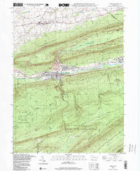 1997 Lykens1999 Print · USGSLykens and Wiconisco are shown here in the late twentieth century, situated between the ridges of the anthracite coal region. Researchers can trace the footprint of local industry and community life through features like strip mines, Fairview Cem, and the Williams Valley Jr High Sch.
 - 1997 Map of Tower City, 1999 Print
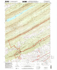
 1997 Tower City1999 Print · USGSThe Schuylkill and Dauphin County borderlands are shown here in the 1990s as a landscape of valley towns and forested ridges. Local historians can trace the development of Tower City, locate the Gold Mine Speedway, and find old cemeteries like Sacred Heart Cem.
 - 1999 Map of Indiantown Gap, 2001 Print
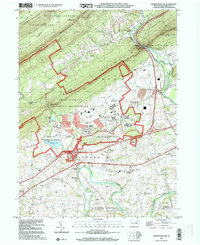 1999 Indiantown Gap2001 Print · USGSLebanon County landscape at the close of the twentieth century shows a region defined by its military heritage and river history. Genealogists and historians can locate family landmarks like Moonshine Ch, trace the old Union Canal, or study the Indiantown Gap Military Reservation.
 - 1999 Map of Grantville, 2001 Print
 1999 Grantville2001 Print · USGSDauphin and Lebanon Counties appear here at the close of the century, where military training grounds and state game lands meet the valley floor. Genealogists and hikers can locate St Pauls Cem, the winding Appalachian National Scenic Trail, and the old crossroads at Manada Gap.
End of results
Showing maps 1-4 of 4
Top cities near Cold Spring Township
- Lebanon historical maps
- Colonial Park historical maps
- Hershey historical maps
- Palmyra historical maps
- Linglestown historical maps
- North Cornwall historical maps
See more
Top neighborhoods of Cold Spring Township
Frequently asked questions
- What are the different types of historical maps available for Cold Spring Township?
- What is the oldest map of Cold Spring Township?
- Where can I purchase historical maps of Cold Spring Township for my home or office?
- Where can I download high-res historical maps of Cold Spring Township?
- Are there historical topographic maps available for Cold Spring Township?
- Is there historical aerial imagery available for Cold Spring Township?
- Where are historical maps of Cold Spring Township sourced from?