1900-1909 Maps of Tioga County, Pennsylvania
Explore 5 historic maps of Tioga County from 1900-1909. These maps offer a rare glimpse into what life looked like during the 1900s — showing old roads, neighborhoods, homes, and landmarks that have changed or disappeared over time.
Whether you're researching your family's past, planning a metal detecting trip, or studying how Tioga County's landscape evolved across the 1900s, these high-resolution maps are a powerful tool for exploring the history of this region.
- Focus on a specific era: All maps on this page are from the 1900s, giving you a focused view of this time period.
- See what’s changed: Compare century-old streets, trails, and buildings to today's modern landscape using overlays and satellite layers.
- Research with precision: Use these maps for genealogy, historical research, land use analysis, or educational projects.
- View, download, or print: Maps are fully viewable online in high resolution, and can be downloaded or printed for your own records.
Start exploring Tioga County's history through authentic maps from the 1900s. This is your window into the past.
Tioga County, PA maps
(5)- 1900 Map of Gaines
 1900 Gaines1900 Print · USGSThe Cowanesque River valley at the turn of the century shows a landscape defined by new rail lines and remote timbering settlements. Genealogists can trace family holdings near Sunderlinville, Harrison Valley, and the rural crossroads of Mixtown and Lansing.5 unique versions available
 - 1900 Map of Tioga
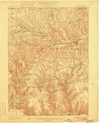
 1900 Tioga1900 Print · USGSTioga County at the turn of the century shows a landscape defined by the busy river corridors and the arrival of major rail networks. Researchers can trace the early footprints of Lawrenceville, Mansfield, and Tioga, or locate rural landmarks like Jackson Summit and Canoe Camp.
 - 1900 Map of Elkland
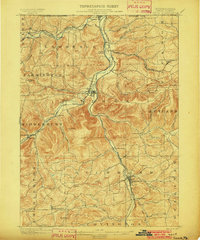
 1900 Elkland1900 Print · USGSTioga County at the turn of the century is defined by its deep river valleys and the expanding rail networks of the Cowanesque River. Genealogists and local historians can trace the early footprints of Knoxville, Academy Corners, and the rail junction at Stokesdale Junc.5 unique versions available
 - 1902 Map of Tioga
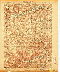
 1902 Tioga1902 Print · USGSNorthern Tioga County at the turn of the century shows a landscape dominated by the convergence of major rail lines and river valleys. Genealogists can trace family roots in riverside settlements like Canoe Camp or explore vanished rail stops like Tompkins and Hammond.5 unique versions available
 - 1905 Map of Watkins Glen
 1905 Watkins Glen1905 Print · USGSThe Finger Lakes and Southern Tier regions are captured at the start of the century, showing a landscape defined by deep glens and heavy rail. Genealogists and historians can trace the paths of the Northern Central RR through Watkins or locate family sites near Burdett and Horseheads.4 unique versions available
End of results
Showing maps 1-5 of 5
Top cities of Tioga County
- Mansfield historical maps
- Wellsboro historical maps
- Elkland historical maps
- Blossburg historical maps
- Westfield historical maps
- Osceola Township historical maps
See more
Frequently asked questions
- What are the different types of historical maps available for Tioga County?
- What is the oldest map of Tioga County?
- Where can I purchase historical maps of Tioga County for my home or office?
- Where can I download high-res historical maps of Tioga County?
- Are there historical topographic maps available for Tioga County?
- Is there historical aerial imagery available for Tioga County?
- Where are historical maps of Tioga County sourced from?