1970s Maps of Tioga County, Pennsylvania
Explore 10 historic maps of Tioga County from the 1970s. These maps offer a rare glimpse into what life looked like during the 1970s — showing old roads, neighborhoods, homes, and landmarks that have changed or disappeared over time.
Whether you're researching your family's past, planning a metal detecting trip, or studying how Tioga County's landscape evolved across the 1970s, these high-resolution maps are a powerful tool for exploring the history of this region.
- Focus on a specific era: All maps on this page are from the 1970s, giving you a focused view of this time period.
- See what’s changed: Compare century-old streets, trails, and buildings to today's modern landscape using overlays and satellite layers.
- Research with precision: Use these maps for genealogy, historical research, land use analysis, or educational projects.
- View, download, or print: Maps are fully viewable online in high resolution, and can be downloaded or printed for your own records.
Start exploring Tioga County's history through authentic maps from the 1970s. This is your window into the past.
Tioga County, PA maps
(10)- 1970 Map of Blossburg, 1972 Print
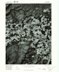
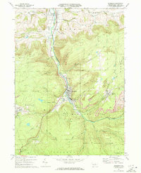 1970 Blossburg1972 Print · USGSTioga County's coal and rail heritage is on full display in the early 1970s as the Erie Lackawanna winds through the river valley. Researchers can trace the layout of mining towns like Arnot and Morris Run or locate family sites at Frost Settlement Cem and Union Cem.4 unique versions available
 - 1970 Map of Cherry Flats, 1972 Print
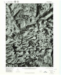
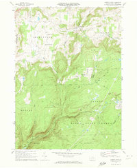 1970 Cherry Flats1972 Print · USGSTioga County’s highland communities and forest industry are preserved here as they appeared in the early seventies. Genealogists and historians can trace the Welsh Settlement area and its Welsh Settlement Ch, or follow the Old Railroad Grade through the Tioga State Forest.3 unique versions available
 - 1970 Map of Gleason, 1972 Print
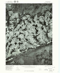
 1970 Gleason1972 Print · USGSThe northern Pennsylvania highlands near the Tioga and Bradford County line are captured here in the early 1970s. Local researchers can trace family landmarks like Gleason and Allen, or locate the North Union Cem and the nearby North Union Ch.4 unique versions available
 - 1977 Map of Tiadaghton, 1979 Print
 1977 Tiadaghton1979 Print · USGSThe Pine Creek gorge and the agricultural uplands of Tioga County are captured in this late-1970s aerial survey. Researchers can trace rural property lines and the layouts of small settlements such as Dexter, Kennedy, and Olmsville.
 - 1977 Map of Nauvoo, 1979 Print
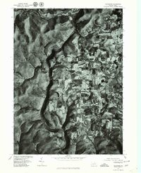
 1977 Nauvoo1979 Print · USGSDuring the late seventies, this rural Tioga County landscape was captured in fine detail via aerial photography. Researchers can pinpoint specific homesteads and land boundaries near Nauvoo, Hartfield, and Plank.
 - 1977 Map of Lee Fire Tower, 1979 Print
 1977 Lee Fire Tower1979 Print · USGSTioga County's timbered highlands are captured in the late 1970s through high-altitude aerial photography. Researchers can trace the rugged drainage patterns of Cushman Branch and Francis Branch or locate the site of the Lee Fire Tower.
 - 1977 Map of Cedar Run, 1979 Print
 1977 Cedar Run1979 Print · USGSIn the Tioga County highlands during the late seventies, this aerial-view survey captures the isolated settlement at Cedar Run. Trace the deep valley floor where the village meets Pine Creek, revealing the forest cover and landscape as it truly was.
 - 1977 Map of Ralston, 1979 Print
 1977 Ralston1979 Print · USGSLycoming County at the end of the 1970s reveals a landscape defined by deep valleys and upland farms. Family historians and researchers can trace the precise 1977 layout of Ralston, Roaring Branch, and the rural fields near Ogdensburg.
 - 1977 Map of Morris, 1979 Print
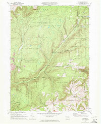
 1977 Morris1979 Print · USGSTioga County agriculture and valley settlements are captured in high detail in the late seventies. Researchers can trace the layout of small communities like Morris and Mt Pleasant or examine the upland farms of Oregon Hill.
 - 1977 Map of Liberty, 1979 Print
 1977 Liberty1979 Print · USGSPennsylvania's Northern Tier comes into focus during the late 1970s through this detailed orthophoto mapping of Tioga County. Genealogists and local historians can trace exact property lines and field patterns surrounding the settlements of Liberty, Sebring, and East Point.
End of results
Showing maps 1-10 of 10
Top cities of Tioga County
- Mansfield historical maps
- Wellsboro historical maps
- Elkland historical maps
- Blossburg historical maps
- Westfield historical maps
- Osceola Township historical maps
See more
Frequently asked questions
- What are the different types of historical maps available for Tioga County?
- What is the oldest map of Tioga County?
- Where can I purchase historical maps of Tioga County for my home or office?
- Where can I download high-res historical maps of Tioga County?
- Are there historical topographic maps available for Tioga County?
- Is there historical aerial imagery available for Tioga County?
- Where are historical maps of Tioga County sourced from?