1990s Maps of Tioga County, Pennsylvania
Explore 9 historic maps of Tioga County from the 1990s. These maps offer a rare glimpse into what life looked like during the 1990s — showing old roads, neighborhoods, homes, and landmarks that have changed or disappeared over time.
Whether you're researching your family's past, planning a metal detecting trip, or studying how Tioga County's landscape evolved across the 1990s, these high-resolution maps are a powerful tool for exploring the history of this region.
- Focus on a specific era: All maps on this page are from the 1990s, giving you a focused view of this time period.
- See what’s changed: Compare century-old streets, trails, and buildings to today's modern landscape using overlays and satellite layers.
- Research with precision: Use these maps for genealogy, historical research, land use analysis, or educational projects.
- View, download, or print: Maps are fully viewable online in high resolution, and can be downloaded or printed for your own records.
Start exploring Tioga County's history through authentic maps from the 1990s. This is your window into the past.
Tioga County, PA maps
(9)- 1992 Map of Elmira, 1993 Print
 1992 Elmira1993 Print · USGSThe Finger Lakes and Southern Tier regions are captured in the early nineties as industrial hubs like Elmira and Endicott thrived alongside university life in Ithaca. Genealogists and researchers can trace the CONRAIL rail corridors, family hilltops such as Hornby Hill, and the extensive Newtown Battlefield Reservation.
 - 1994 Map of Cedar Run, 1998 Print
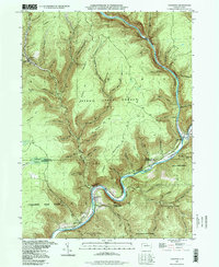 1994 Cedar Run1998 Print · USGSThe deep canyons of the Grand Canyon of Pennsylvania are captured here during the late twentieth century. Researchers can trace the river-level settlements of Blackwell and Cedar Run or locate high-country landmarks like Mine Hole Hill and Leetonia.
 - 1994 Map of Keeneyville, 1998 Print
 1994 Keeneyville1998 Print · USGSTioga County life in the late twentieth century is documented here along the winding valleys of Crooked Creek and Marsh Creek. Researchers can trace the legacy of small communities and rural institutions like the Catlin Hollow Ch and Niles Valley Cem.
 - 1994 Map of Tiadaghton, 1998 Print
 1994 Tiadaghton1998 Print · USGSTioga County's breathtaking canyon country comes into focus in the mid-nineties, showing the intersection of state park conservation and rural plateau life. Genealogists and hikers can trace old landmarks such as Middle Ridge Church, West Branch Cemetery, and the dramatic overlooks at Barbour Rock.
 - 1994 Map of Crooked Creek, 1999 Print
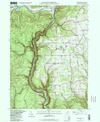
 1994 Crooked Creek1999 Print · USGSTioga County's rural valleys and northern highlands are captured here in the late twentieth century, showing a landscape defined by state parks and small crossroads. Researchers can locate community anchors like Whitneyville, the Hills Creek Ch, and the Dartt Settlement Cem.
 - 1994 Map of Morris, 1999 Print
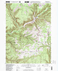 1994 Morris1999 Print · USGSThe Pennsylvania backcountry near the Tioga and Lycoming border is captured here in the 1990s, centered on the valley hamlets of Morris and Hoytville. Researchers can trace old mountain roads and local landmarks like Lewis Cem and the Crawford Fire Tower.
 - 1994 Map of Lee Fire Tower, 1999 Print
 1994 Lee Fire Tower1999 Print · USGSThe convergence of three state forests in the Pennsylvania highlands is documented in the mid-1990s, showing a land of deep hollows and timber ridges. Researchers can trace forest industrial history via the CLAY MINE, PIPELINE ROAD, and the landmark Lee Fire Tower.
 - 1999 Map of Mansfield, 2001 Print
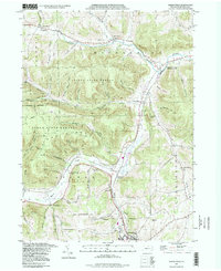
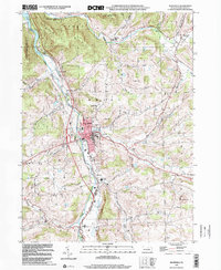 1999 Mansfield2001 Print · USGSNorthern Tioga County's river valley comes to life at the turn of the millennium, centered on the growing borough of Mansfield. Genealogists can trace family plots at Oakwood Cem and Mainesburg Cem or explore the Mansfield University campus.
 - 1999 Map of Elkland, 2001 Print
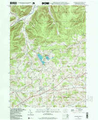
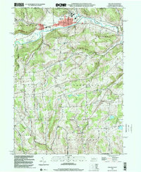 1999 Elkland2001 Print · USGSThe Cowanesque River valley at the New York border is shown here at the close of the twentieth century. Researchers can trace family roots through numerous highland burial grounds like Taylor Cem and rural centers such as Karls Corners and Farmington Ch.
End of results
Showing maps 1-9 of 9
Top cities of Tioga County
- Mansfield historical maps
- Wellsboro historical maps
- Elkland historical maps
- Blossburg historical maps
- Westfield historical maps
- Osceola Township historical maps
See more
Frequently asked questions
- What are the different types of historical maps available for Tioga County?
- What is the oldest map of Tioga County?
- Where can I purchase historical maps of Tioga County for my home or office?
- Where can I download high-res historical maps of Tioga County?
- Are there historical topographic maps available for Tioga County?
- Is there historical aerial imagery available for Tioga County?
- Where are historical maps of Tioga County sourced from?