1920s Maps of Tioga County, Pennsylvania
Explore 4 historic maps of Tioga County from the 1920s. These maps offer a rare glimpse into what life looked like during the 1920s — showing old roads, neighborhoods, homes, and landmarks that have changed or disappeared over time.
Whether you're researching your family's past, planning a metal detecting trip, or studying how Tioga County's landscape evolved across the 1920s, these high-resolution maps are a powerful tool for exploring the history of this region.
- Focus on a specific era: All maps on this page are from the 1920s, giving you a focused view of this time period.
- See what’s changed: Compare century-old streets, trails, and buildings to today's modern landscape using overlays and satellite layers.
- Research with precision: Use these maps for genealogy, historical research, land use analysis, or educational projects.
- View, download, or print: Maps are fully viewable online in high resolution, and can be downloaded or printed for your own records.
Start exploring Tioga County's history through authentic maps from the 1920s. This is your window into the past.
Tioga County, PA maps
(4)- 1924 Map of Woodhull
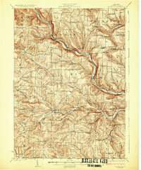
 1924 Woodhull1924 Print · USGSSteuben County in the mid-twenties is a landscape of high ridges and school-centered rural districts. Genealogists can trace family names and local hubs from Cameron Mills to Rathbone, including the Eight Square School and the Erie RR line.
 - 1925 Map of Blossburg, 1958 Print
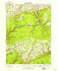 1925 Blossburg1958 Print · USGSTioga County’s coal and timber country is captured here during the 1920s, when the Tioga River and Erie R R drove the local economy. Researchers can locate dozens of country schoolhouses, rural churches like Burt Church, and early industrial sites such as Blacks Mill.2 unique versions available
 - 1926 Map of Woodhull
 1926 Woodhull1926 Print · USGSSteuben County rural life in the mid-1920s is defined by the Canisteo River valley and a network of hilltop school districts. Researchers can trace family-named landmarks like Kinners Knob or locate vanished local hubs like Hedgesville and Cameron Mills.4 unique versions available
 - 1927 Map of Blossburg
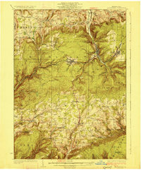 1927 Blossburg1927 Print · USGSTioga County's coal country and rural townships are captured here in the mid-1920s, showing the height of the mountain rail and mining era. Genealogists can locate family-named sites like Blacks Mill, Hart Church, and vanished schoolhouses such as Culver School.4 unique versions available
End of results
Showing maps 1-4 of 4
Top cities of Tioga County
- Mansfield historical maps
- Wellsboro historical maps
- Elkland historical maps
- Blossburg historical maps
- Westfield historical maps
- Osceola Township historical maps
See more
Frequently asked questions
- What are the different types of historical maps available for Tioga County?
- What is the oldest map of Tioga County?
- Where can I purchase historical maps of Tioga County for my home or office?
- Where can I download high-res historical maps of Tioga County?
- Are there historical topographic maps available for Tioga County?
- Is there historical aerial imagery available for Tioga County?
- Where are historical maps of Tioga County sourced from?