1980s Maps of Wagener, South Carolina
Explore 3 historic maps of Wagener from the 1980s. These maps offer a rare glimpse into what life looked like during the 1980s — showing old roads, neighborhoods, homes, and landmarks that have changed or disappeared over time.
Whether you're researching your family's past, planning a metal detecting trip, or studying how Wagener's landscape evolved across the 1980s, these high-resolution maps are a powerful tool for exploring the history of this region.
- Focus on a specific era: All maps on this page are from the 1980s, giving you a focused view of this time period.
- See what’s changed: Compare century-old streets, trails, and buildings to today's modern landscape using overlays and satellite layers.
- Research with precision: Use these maps for genealogy, historical research, land use analysis, or educational projects.
- View, download, or print: Maps are fully viewable online in high resolution, and can be downloaded or printed for your own records.
Start exploring Wagener's history through authentic maps from the 1980s. This is your window into the past.
Wagener, SC maps
(3)- 1983 Map of Aiken, 1984 Print
 1983 Aiken1984 Print · USGSThe Savannah River valley and South Carolina sandhills are shown in detail during the early eighties, as industry and education expanded. Researchers can trace the rail corridors of the Southern and Seaboard Coast Line through communities like Graniteville and Leesville.
 - 1986 Map of Seivern
 1986 Seivern1986 Print · USGSThe borderlands of Aiken and Lexington Counties come alive in the mid-eighties, centered on the North Fork Edisto River and the settlement of Seivern. Researchers can locate old family burial grounds, the grounds of Camp Rawl, and local industrial sites like the Clay Pits.
 - 1986 Map of Wagener
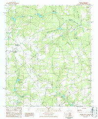
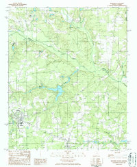 1986 Wagener1986 Print · USGSThe South Carolina Midlands come into focus during the mid-1980s, centered on the rural crossroads and river bends of Aiken County. Genealogists and local historians can trace the foundations of Wagener and Perry or locate family landmarks like Collums Millpond and Poole Pond.
End of results
Showing maps 1-3 of 3
Top cities near Wagener
- Williston historical maps
- Pelion historical maps
- Springfield historical maps
- Salley historical maps
- Perry historical maps
- Windsor historical maps
See more
Frequently asked questions
- What are the different types of historical maps available for Wagener?
- What is the oldest map of Wagener?
- Where can I purchase historical maps of Wagener for my home or office?
- Where can I download high-res historical maps of Wagener?
- Are there historical topographic maps available for Wagener?
- Is there historical aerial imagery available for Wagener?
- Where are historical maps of Wagener sourced from?