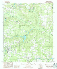
1986 Map of Wagener
USGS Topo · Published 1986About this map
The North Fork Edisto River carves a winding path through this portion of Aiken and Lexington Counties, dictating the settlement patterns and agricultural layout of the mid-1980s. The town of Wagener stands as the primary hub in the southwest, while smaller communities like Berlin, Perry, and Ritter anchor the surrounding rural landscape. Water management is a defining characteristic of the terrain, evidenced by numerous named impoundments such as Collums Millpond, Poole Pond, and the Barns Ponds. These water bodies, along with tributaries like Giddy Swamp Creek and Black Creek, reflect a landscape deeply tied to its hydrologic network. The map captures a specific moment in the rural development of the South Carolina Midlands, showing the distribution of local cemeteries and the persistent boundary line between Lexington and Aiken Counties.
Find a feature on this map
22 named features on this map. Tap any name to fly to it.
Don’t see what you’re looking for? This feature index may not catch every label — zoom into the map to look around manually.
Map Details
Editions of this 1986 Wagener Map
This is the sole edition of this map. No revisions or reprints were ever made.
Other maps of this area

1944 · Gilbert
USGS Topo · 1:62,500

1944 · Seivern
USGS Topo · 1:62,500

1944 · Edmund
USGS Topo · 1:62,500

1946 · Woodford
USGS Topo · 1:62,500

1954 · Augusta
USGS Topo · 1:250,000

1957 · Augusta
USGS Topo · 1:250,000

1958 · Augusta
USGS Topo · 1:250,000

1961 · Augusta
USGS Topo · 1:250,000

1962 · Augusta
USGS Topo · 1:250,000
1972 · Pelion East
USGS Topo · 1:24,000