1980s Maps of Berkeley County, South Carolina
Explore 7 historic maps of Berkeley County from the 1980s. These maps offer a rare glimpse into what life looked like during the 1980s — showing old roads, neighborhoods, homes, and landmarks that have changed or disappeared over time.
Whether you're researching your family's past, planning a metal detecting trip, or studying how Berkeley County's landscape evolved across the 1980s, these high-resolution maps are a powerful tool for exploring the history of this region.
- Focus on a specific era: All maps on this page are from the 1980s, giving you a focused view of this time period.
- See what’s changed: Compare century-old streets, trails, and buildings to today's modern landscape using overlays and satellite layers.
- Research with precision: Use these maps for genealogy, historical research, land use analysis, or educational projects.
- View, download, or print: Maps are fully viewable online in high resolution, and can be downloaded or printed for your own records.
Start exploring Berkeley County's history through authentic maps from the 1980s. This is your window into the past.
Berkeley County, SC maps
(7)- 1980 Map of Jordan
 1980 Jordan1980 Print · USGSClarendon County in the early eighties shows a landscape of rural crossroads and growing lakeside recreation along the Santee. Genealogists and historians can locate several country churches like St Matthews Ch and trace the Old RR Grade near Jordan.2 unique versions available
 - 1985 Map of Saint George, 1986 Print
 1985 Saint George1986 Print · USGSThe South Carolina Lowcountry in the mid-eighties shows a landscape defined by the great reservoirs and the meandering Edisto River. Researchers can trace the rail corridors of the Southern Railway and find rural settlements like Harleyville, Smoaks, and Grover.
 - 1986 Map of Georgetown
 1986 Georgetown1986 Print · USGSThe South Carolina Lowcountry is captured here in the mid-1980s, centered on the historic port of Georgetown and its surrounding wetlands. Researchers can trace the river-fed economy and land patterns of Waccamaw Neck, Hampton Plantation State Park, and the timber-rich Francis Marion National Forest.2 unique versions available
 - 1986 Map of James Island
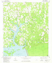
 1986 James Island1986 Print · USGSCharleston and its surrounding sea islands are captured in the mid-1980s, showcasing a region defined by maritime heritage and rapid coastal expansion. Genealogists and historians can trace established neighborhoods like Scanlonville, landmarks such as Fort Sumter, and the era's infrastructure including the Grace Mem Br.
 - 1986 Map of Kingstree
 1986 Kingstree1986 Print · USGSThe South Carolina Lowcountry in the mid-eighties shows a landscape defined by the Black River and the growing coastal communities of the Grand Strand. Researchers can trace historic river settlements and rail stops like Salters Depot, Pamplico, and Hemingway.2 unique versions available
 - 1986 Map of Walterboro
 1986 Walterboro1986 Print · USGSThe South Carolina Lowcountry in the mid-eighties remains a world of expansive wetlands and historic river crossings. Genealogists and historians can trace the rural communities and landmarks of Colleton and Charleston counties, from the Baptist Church at Adams Run to the coastal reaches of Edisto Beach State Park.
 - 1986 Map of Sumter
 1986 Sumter1986 Print · USGSMid-South Carolina in the mid-eighties reveals a landscape of massive river bottomlands and significant military installations. Genealogists and historians can trace the rural networks around Fort Motte, Lone Star, and Sardinia alongside Lake Marion.
End of results
Showing maps 1-7 of 7
Top cities of Berkeley County
- Goose Creek historical maps
- Hanahan historical maps
- Moncks Corner historical maps
- Bonneau historical maps
- Jamestown historical maps
Frequently asked questions
- What are the different types of historical maps available for Berkeley County?
- What is the oldest map of Berkeley County?
- Where can I purchase historical maps of Berkeley County for my home or office?
- Where can I download high-res historical maps of Berkeley County?
- Are there historical topographic maps available for Berkeley County?
- Is there historical aerial imagery available for Berkeley County?
- Where are historical maps of Berkeley County sourced from?