1990s Maps of Berkeley County, South Carolina
Explore 11 historic maps of Berkeley County from the 1990s. These maps offer a rare glimpse into what life looked like during the 1990s — showing old roads, neighborhoods, homes, and landmarks that have changed or disappeared over time.
Whether you're researching your family's past, planning a metal detecting trip, or studying how Berkeley County's landscape evolved across the 1990s, these high-resolution maps are a powerful tool for exploring the history of this region.
- Focus on a specific era: All maps on this page are from the 1990s, giving you a focused view of this time period.
- See what’s changed: Compare century-old streets, trails, and buildings to today's modern landscape using overlays and satellite layers.
- Research with precision: Use these maps for genealogy, historical research, land use analysis, or educational projects.
- View, download, or print: Maps are fully viewable online in high resolution, and can be downloaded or printed for your own records.
Start exploring Berkeley County's history through authentic maps from the 1990s. This is your window into the past.
Berkeley County, SC maps
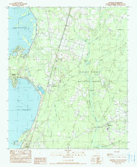
(11)- 1990 Map of Blakely
 1990 Blakely1990 Print · USGSThe lowlands of Williamsburg and Berkeley counties are mapped here in the early nineties as the riverine forest transitions to upland farm plots. Genealogists and researchers can trace the vicinity of Blakely, locate a rural Cem, and follow the water through Mattassee Lake.
 - 1990 Map of Walterboro
 1990 Walterboro1990 Print · USGSCoastal South Carolina and its dense river networks are documented here in the early nineties as the Charleston suburbs expanded westward. Genealogists and historians can trace old community hubs like Clubhouse Crossroads, the site of Givhans Ferry, and several Strip Mines north of the Stono River.
 - 1990 Map of James Island
 1990 James Island1990 Print · USGSCoastal South Carolina in the early nineties reveals a landscape where historic harbor defenses and naval installations meet expanding suburban reaches. Trace the evolution of waterfront communities from Folly Beach to Mount Pleasant, and locate maritime landmarks like the USS Yorktown State Park or the Lighthouse on Morris Island.
 - 1990 Map of Saint George
 1990 Saint George1990 Print · USGSThe South Carolina Lowcountry in the early nineties reveals a complex network of river systems and massive reservoirs. Genealogists and local historians can trace the development of inland settlements like St George and Branchville or explore the wetlands of Four Hole Swamp.
 - 1990 Map of St. Stephen
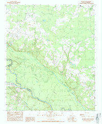
 1990 St. Stephen1990 Print · USGSThe Berkeley County Lowcountry is captured here in the early 1990s, showcasing the intersection of rail infrastructure and vast swamp networks. Genealogists and historians can trace local homesteads near St Stephen and Russellville, or locate burial sites at the several Cem locations marked throughout the landscape.
 - 1990 Map of Greeleyville
 1990 Greeleyville1990 Print · USGSGreeleyville and the Williamsburg County backcountry are captured in the early nineties as the region’s wetland-driven economy matured. Genealogists and local historians can trace family-named sites across Burgess Bay, Heineman, and the banks of the Santee River.
 - 1990 Map of Sumter
 1990 Sumter1990 Print · USGSCentral South Carolina's river systems and military landscapes are captured here during the late twentieth century. Genealogists and historians can trace the growth of Sumter or locate rural communities such as Wedgefield and Kingville near the Congaree River.
 - 1990 Map of Bonneau
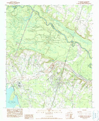
 1990 Bonneau1990 Print · USGSBerkeley County's lakefront and forest interior are captured here in the early 1990s as modern recreation meets traditional lowcountry landscapes. Trace the development of Bonneau Beach, the wetlands of Wadboo Swamp, and local landmarks like the Fish Hatchery.
 - 1990 Map of Alvin
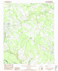
 1990 Alvin1990 Print · USGSBerkeley County was still defined by its deep swamp forests and riverine borders in the early 1990s. Genealogists and local historians can locate remote family burials at several Cem sites and trace the meandering Santee River past Alvin and Wittee Lake.
 - 1994 Map of Charleston, 2000 Print
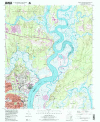
 1994 Charleston2000 Print · USGSMid-century Charleston and its harbor islands are shown in detail as the city expanded toward Mount Pleasant and Saint Andrews. Genealogists and historians can locate legacy sites like Magnolia Cem, The Citadel, and the historic Scanlonville settlement.
 - 1998 Map of North Charleston, 1999 Print
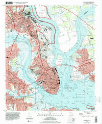
 1998 North Charleston1999 Print · USGSNorth Charleston and the surrounding river reaches are shown here in the late nineties, balancing heavy military presence with growing suburban neighborhoods. Trace the industrial waterfront at the Port Terminal and locate community anchors like Park Circle and St Johns Ch.
End of results
Showing maps 1-11 of 11
Top cities of Berkeley County
- Goose Creek historical maps
- Hanahan historical maps
- Moncks Corner historical maps
- Bonneau historical maps
- Jamestown historical maps
Frequently asked questions
- What are the different types of historical maps available for Berkeley County?
- What is the oldest map of Berkeley County?
- Where can I purchase historical maps of Berkeley County for my home or office?
- Where can I download high-res historical maps of Berkeley County?
- Are there historical topographic maps available for Berkeley County?
- Is there historical aerial imagery available for Berkeley County?
- Where are historical maps of Berkeley County sourced from?