1950s Maps of Berkeley County, South Carolina
Explore 17 historic maps of Berkeley County from the 1950s. These maps offer a rare glimpse into what life looked like during the 1950s — showing old roads, neighborhoods, homes, and landmarks that have changed or disappeared over time.
Whether you're researching your family's past, planning a metal detecting trip, or studying how Berkeley County's landscape evolved across the 1950s, these high-resolution maps are a powerful tool for exploring the history of this region.
- Focus on a specific era: All maps on this page are from the 1950s, giving you a focused view of this time period.
- See what’s changed: Compare century-old streets, trails, and buildings to today's modern landscape using overlays and satellite layers.
- Research with precision: Use these maps for genealogy, historical research, land use analysis, or educational projects.
- View, download, or print: Maps are fully viewable online in high resolution, and can be downloaded or printed for your own records.
Start exploring Berkeley County's history through authentic maps from the 1950s. This is your window into the past.
Berkeley County, SC maps
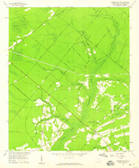
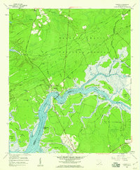
(17)- 1950 Map of Huger
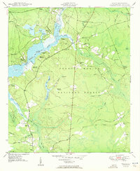 1950 Huger1950 Print · USGSMid-century Berkeley County comes alive here, showing the riverfront plantations and forest reserves just after the war. Genealogists can trace family sites at Bossis Plantation, Slave Cem, and the rural Pompon Hill Chapel.5 unique versions available
 - 1950 Map of Bethera
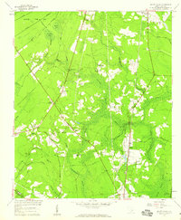
 1950 Bethera1950 Print · USGSBerkeley County was characterized by dense forests and expansive wetlands at mid-century, just as the national forest system was maturing. Genealogists and historians can locate the Bethel Ch Cem, the Seaboard Air Line rail route, and old homesteads at Kensington.2 unique versions available
 - 1950 Map of Kittredge
 1950 Kittredge1950 Print · USGSThe Cooper River waterfront in the mid-century remains a landscape of historic landings and rural settlements before modern development. Researchers can trace family sites at the Promised Land Ch, the historic Strawberry Chapel, and the vast U S Army Ordnance Depot.4 unique versions available
 - 1954 Map of Augusta
 1954 Augusta1954 Print · USGSThe Savannah River valley and South Carolina Midlands are captured here during a period of post-war growth. Researchers can trace the rail-and-river economy through the Southern RR corridor and locate historic settlements like Aiken, Orangeburg, and Sumter.
 - 1957 Map of Mount Holly, 1959 Print
 1957 Mount Holly1959 Print · USGSBerkeley County was characterized by dense swamplands and rural railroad hamlets in the mid-1950s. Genealogists can trace family roots through numerous local landmarks, including Varner Sch, Driggerstown, and the Groomsville Cem.4 unique versions available
 - 1957 Map of Augusta, 1966 Print
 1957 Augusta1966 Print · USGSThe Savannah River and Santee basins are captured here during a period of massive military and industrial expansion in the late fifties. Genealogists can trace family footprints across Four Hole Swamp or near the Savannah River Plant.3 unique versions available
 - 1957 Map of Savannah, 1967 Print
 1957 Savannah1967 Print · USGSThe Lowcountry and Georgia coastal plain are shown here in the late fifties, prior to modern expansion. Researchers can trace the rail-and-river economy through the Central of Georgia lines and the Ogeechee River wetlands.4 unique versions available
 - 1958 Map of Augusta
 1958 Augusta1958 Print · USGSThe borderlands between Georgia and South Carolina come alive in the 1950s, showing the early footprint of the Savannah River Plant. Genealogists and historians can trace rail-dependent towns and rural landmarks from Orangeburg to the Fort Jackson Military Reservation.
 - 1958 Map of North Charleston, 1959 Print
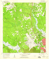
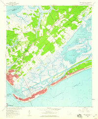
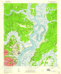 1958 North Charleston1959 Print · USGSNorth Charleston in the late fifties shows a booming industrial and military hub defined by its riverfront access. Researchers can trace the mid-century development of Park Circle, the massive Port Terminal, and community cornerstones like the Orphanage and Oak Terrace Sch.4 unique versions available
 - 1958 Map of Charleston, 1959 Print
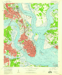 1958 Charleston1959 Print · USGSCharleston and its surrounding coastal islands are shown here in the late fifties as the city expanded northward and across its rivers. Researchers can locate long-standing institutions like The Citadel or trace family roots through historic sites like Magnolia Cem and Whipper Barony.5 unique versions available
 - 1958 Map of Summerville NW, 1959 Print
 1958 Summerville NW1959 Print · USGSBerkeley County was characterized by deep wetlands and isolated rural communities in the late fifties. Genealogists and researchers can trace local family centers at Lebanon Ch, Wassamassaw Ch, and the Millpond near Coton Bay.3 unique versions available
 - 1958 Map of Summerville, 1959 Print
 1958 Summerville1959 Print · USGSSummerville and its surrounding Lowcountry reaches appear here in the late fifties as a network of rail-side settlements and vast wetlands. Trace local history through landmarks like Jedburg, the Alston Schools, and the winding Cypress Swamp.4 unique versions available
 - 1958 Map of Ladson, 1959 Print
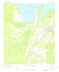
 1958 Ladson1959 Print · USGSCoastal South Carolina is captured here in a moment of rapid military and industrial growth during the late fifties. You can trace the expansion of North Charleston and the Charleston Air Force Base alongside historic riverfront landmarks like Magnolia Gardens.4 unique versions available
 - 1958 Map of Moncks Corner, 1959 Print
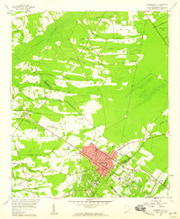
 1958 Moncks Corner1959 Print · USGSBerkeley County life in the late fifties centered on the growing hub of Moncks Corner and the vast waters of Lake Moultrie. Researchers can trace rural family roots through landmarks like the Whitesville Sch, The Oak Chapel, and the Atlantic Coast Line railroad.3 unique versions available
 - 1958 Map of Cainhoy, 1960 Print
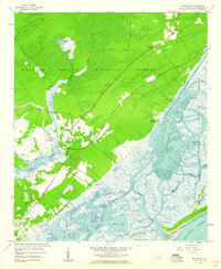
 1958 Cainhoy1960 Print · USGSCoastal South Carolina is captured here in the late fifties, where the river-and-marsh economy still dictates the local geography. Researchers can trace historic family landmarks and burial grounds like McDowell Cem, St Pauls Ch, and Martins Point Landing.3 unique versions available
 - 1959 Map of Fort Moultrie, 1960 Print
 1959 Fort Moultrie1960 Print · USGSThe Charleston coast comes into focus during the late fifties, showing the established waterfront communities and defensive landmarks of the harbor. Genealogists and historians can trace local landmarks like Christ Church, the Confederate Cem, and Fort Moultrie.5 unique versions available
 - 1959 Map of Sewee Bay, 1960 Print
 1959 Sewee Bay1960 Print · USGSThe South Carolina Lowcountry coastline in the late fifties is captured here through the dense forests and expansive tidal marshes of Charleston County. Genealogists and researchers can trace community roots through Wappetaw Cem, Sewee Ch, and the small settlement at Woodville.4 unique versions available
End of results
Showing maps 1-17 of 17
Top cities of Berkeley County
- Goose Creek historical maps
- Hanahan historical maps
- Moncks Corner historical maps
- Bonneau historical maps
- Jamestown historical maps
Frequently asked questions
- What are the different types of historical maps available for Berkeley County?
- What is the oldest map of Berkeley County?
- Where can I purchase historical maps of Berkeley County for my home or office?
- Where can I download high-res historical maps of Berkeley County?
- Are there historical topographic maps available for Berkeley County?
- Is there historical aerial imagery available for Berkeley County?
- Where are historical maps of Berkeley County sourced from?