1910s Maps of Berkeley County, South Carolina
Explore 9 historic maps of Berkeley County from the 1910s. These maps offer a rare glimpse into what life looked like during the 1910s — showing old roads, neighborhoods, homes, and landmarks that have changed or disappeared over time.
Whether you're researching your family's past, planning a metal detecting trip, or studying how Berkeley County's landscape evolved across the 1910s, these high-resolution maps are a powerful tool for exploring the history of this region.
- Focus on a specific era: All maps on this page are from the 1910s, giving you a focused view of this time period.
- See what’s changed: Compare century-old streets, trails, and buildings to today's modern landscape using overlays and satellite layers.
- Research with precision: Use these maps for genealogy, historical research, land use analysis, or educational projects.
- View, download, or print: Maps are fully viewable online in high resolution, and can be downloaded or printed for your own records.
Start exploring Berkeley County's history through authentic maps from the 1910s. This is your window into the past.
Berkeley County, SC maps
(9)- 1919 Map of Ladson
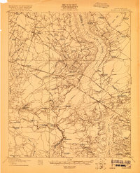
 1919 Ladson1919 Print · USGSThe South Carolina lowcountry is captured here just after the Great War, showing a landscape of riverfront estates and rail-connected settlements. Researchers can trace the grounds of Magnolia Gardens or locate rural centers like Ladson and Otranto.2 unique versions available
 - 1919 Map of Summerville
 1919 Summerville1919 Print · USGSSummerville and the surrounding Lowcountry wetlands are captured here just after the Great War, during a period of established rail reliance and rural growth. Genealogists and researchers can trace local landmarks like St Johns Church, the Clemson Coast Express Station, and numerous early school sites including Barrow School.
 - 1919 Map of Ridgeville
 1919 Ridgeville1919 Print · USGSCoastal South Carolina at the end of the Great War era reveals a landscape of dense swamps and rail-side settlements. Genealogists can trace family roots through numerous local landmarks like Cypress Camp Meeting Grounds, Mudville School, and Limestone Church.
 - 1919 Map of Wando
 1919 Wando1919 Print · USGSCoastal Berkeley and Charleston Counties come alive in this survey from just after the Great War. Genealogists can locate family landmarks like St Matthews Church, trace the winding Lumber R. R., or find old river access at Lachicotte Landing.5 unique versions available
 - 1919 Map of Cordesville
 1919 Cordesville1919 Print · USGSBerkeley County was a landscape of dense swamps and historic parish chapels just after the First World War. Genealogists can trace family roots through numerous sites like Strawberry Chapel, Bethera Church, and the rural Pine Grove Flag Station.2 unique versions available
 - 1919 Map of Melgrove
 1919 Melgrove1919 Print · USGSThe South Carolina lowcountry emerges in detail during the post-WWI era as industry begins to touch the Cooper River. Genealogists can trace early neighborhood footprints in North Charleston or locate rural landmarks like St.Johns Church and Redbank Landing.3 unique versions available
 - 1919 Map of Charleston
 1919 Charleston1919 Print · USGSCoastal South Carolina thrives at the height of its naval and rail importance in the years following the Great War. Genealogists and historians can trace the development of the Navy Yard and local landmarks like Castle Pinckney and Magnolia Cem.3 unique versions available
 - 1919 Map of Fort Moultrie
 1919 Fort Moultrie1919 Print · USGSThe Charleston coast at the end of the Great War reveals a landscape of strategic coastal fortifications and early island settlements. Genealogists and historians can trace the layouts of Moultrieville, Mt Pleasant, and the grounds of Fort Moultrie.3 unique versions available
 - 1919 Map of Sewee Bay
 1919 Sewee Bay1919 Print · USGSThe Charleston County coastline at the end of the Great War reveals a landscape of tidal marshes and interior timber operations. Genealogists can trace the rural school system through Twelvemile School and Eighteenmile School or locate the early footprints of Andersonville and Woodville.
End of results
Showing maps 1-9 of 9
Top cities of Berkeley County
- Goose Creek historical maps
- Hanahan historical maps
- Moncks Corner historical maps
- Bonneau historical maps
- Jamestown historical maps
Frequently asked questions
- What are the different types of historical maps available for Berkeley County?
- What is the oldest map of Berkeley County?
- Where can I purchase historical maps of Berkeley County for my home or office?
- Where can I download high-res historical maps of Berkeley County?
- Are there historical topographic maps available for Berkeley County?
- Is there historical aerial imagery available for Berkeley County?
- Where are historical maps of Berkeley County sourced from?