1940s Maps of Charleston County, South Carolina
Explore 30 historic maps of Charleston County from the 1940s. These maps offer a rare glimpse into what life looked like during the 1940s — showing old roads, neighborhoods, homes, and landmarks that have changed or disappeared over time.
Whether you're researching your family's past, planning a metal detecting trip, or studying how Charleston County's landscape evolved across the 1940s, these high-resolution maps are a powerful tool for exploring the history of this region.
- Focus on a specific era: All maps on this page are from the 1940s, giving you a focused view of this time period.
- See what’s changed: Compare century-old streets, trails, and buildings to today's modern landscape using overlays and satellite layers.
- Research with precision: Use these maps for genealogy, historical research, land use analysis, or educational projects.
- View, download, or print: Maps are fully viewable online in high resolution, and can be downloaded or printed for your own records.
Start exploring Charleston County's history through authentic maps from the 1940s. This is your window into the past.
Charleston County, SC maps
(30)- 1940 Map of Melgrove
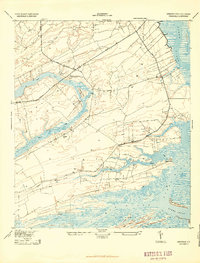
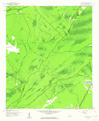
 1940 Melgrove1940 Print · USGSThe South Carolina lowcountry near Charleston appears here just before the mid-century industrial boom. Researchers can locate community anchors like St Johns Ch, the No 6 School, and the rail stop at Inness Sta along the SOUTHERN line.
 - 1942 Map of Cape Romain, 1962 Print
 1942 Cape Romain1962 Print · USGSThe South Carolina coast near the Santee Delta is shown here in the early 1940s, capturing a pristine network of barrier islands and salt marshes. Maritime researchers can trace the historic Intracoastal Waterway and locate landmarks like Lighthouse Island and Deepwater Point.4 unique versions available
 - 1942 Map of Mc Clellanville, 1962 Print
 1942 Mc Clellanville1962 Print · USGSThe South Carolina Lowcountry during the early war years is captured here through the intricate marshes and waterways of the McClellanville coast. Genealogists and historians can trace local landmarks like Lincoln Sch, Rhems Ch, and the outlying Moores Corner settlement.5 unique versions available
 - 1942 Map of Honey Hill, 1962 Print
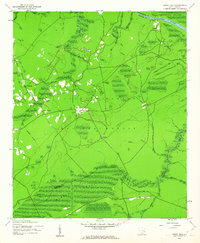 1942 Honey Hill1962 Print · USGSBerkeley County was still largely defined by its river-and-swamp geography during the early 1940s. Local researchers can trace old crossroads like Honey Hill and Charley Bridges, or locate river access points including Pleasant Hill Landing and Pitch Landing.3 unique versions available
 - 1943 Map of Capers Island
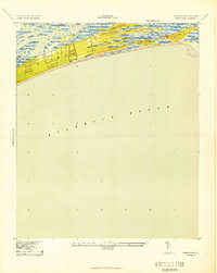
 1943 Capers Island1943 Print · USGSThe South Carolina coast near Charleston appears in high detail during the early 1940s, highlighting the undeveloped barrier islands and complex marsh systems. Maritime researchers can trace historic water passages like Capers Inlet, Price Inlet, and the tidal reaches of the Morgan River.2 unique versions available
 - 1943 Map of Cottageville
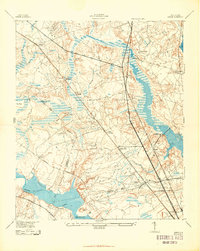
 1943 Cottageville1943 Print · USGSThe South Carolina Lowcountry in the early forties reveals a landscape of river landings and remote crossroads between the Edisto and the swamps. Genealogists can trace family landmarks and school sites like Rehoboth Sch or locate the old Sullivans Ferry crossing.
 - 1943 Map of Fort Moultrie
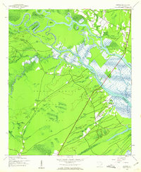
 1943 Fort Moultrie1943 Print · USGSThe Charleston coast at the height of the war reveals a landscape of tactical significance and growing seaside communities. Genealogists and historians can trace old homesteads near Porchers Bluff or locate the Atlanticville P O and Sevenmile Sch.2 unique versions available
 - 1943 Map of Legareville
 1943 Legareville1943 Print · USGSThe South Carolina lowcountry islands are captured here during the 1940s, showing a world of tidal creeks and rural island life. Genealogists can trace family footprints at Legareville, Miller Hill, and local landmarks like Sandhill School and Zion Church.2 unique versions available
 - 1943 Map of Edisto Island
 1943 Edisto Island1943 Print · USGSThe South Carolina Lowcountry is captured here in the early 1940s, showing a landscape of tidal islands and rail-side settlements. Researchers can trace the layout of Freedman Village, find old school sites like Seaside Sch, and locate the docks at Steamboat Landing.
 - 1943 Map of James Island
 1943 James Island1943 Print · USGSCoastal South Carolina comes alive in the mid-1940s, revealing a landscape of tidal marshes and early island settlements. Trace family roots and maritime history through Secessionville, Payne Chapel, and the Morris Island Coast Guard Station.2 unique versions available
 - 1943 Map of Wando
 1943 Wando1943 Print · USGSThe Lowcountry river system near Wando and Cainhoy is captured here during the mid-forties, showing the intricate tidal creeks and rural landings of the era. Genealogists and local historians can locate family landmarks like St Pauls Ch, Philips Sch, and the winding Lumber Railroad.3 unique versions available
 - 1943 Map of Sewee Bay
 1943 Sewee Bay1943 Print · USGSThe Charleston County coastline in the early 1940s reveals a quiet landscape of rural schools and tidal marshes before the onset of modern coastal development. Local historians can trace the positions of Twelvemile Sch and Eighteenmile Sch or explore the waterfronts of Woodville and Andersonville.
 - 1943 Map of Bulls Island
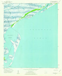
 1943 Bulls Island1943 Print · USGSCoastal South Carolina during the war years reveals an intricate maritime landscape of barrier islands and tidal marshes. Researchers can trace historic landmarks like the Old Fort on Bulls Island or navigate the winding reaches of Vanderhorst Creek and the Intercoastal Waterway.
 - 1943 Map of Kiawah Island
 1943 Kiawah Island1943 Print · USGSKiawah Island and the South Carolina coast appear here during the mid-forties, showing the landscape as a quiet expanse of tidal marshes and beaches. Researchers can trace the winding course of the Kiawah River and identify landmarks like Cinder Point and Sandy Point.2 unique versions available
 - 1943 Map of Ladson
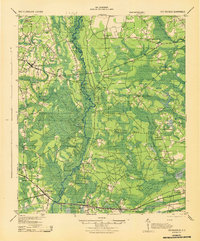
 1943 Ladson1943 Print · USGSBerkeley and Dorchester counties come into focus during the early war years, revealing a landscape of historic river estates and new military infrastructure. Genealogists and historians can trace family-named sites like Windsor Hill and Ararat, or locate local landmarks like Goose Creek Ch and Magnolia Gardens.2 unique versions available
 - 1943 Map of Shulerville, 1962 Print
 1943 Shulerville1962 Print · USGSBerkeley County was a landscape of deep wetlands and isolated crossroads in the years following the Great Depression. Genealogists and researchers can trace family landmarks like Windom Corner and Farewell Corner or locate rural congregations at Bethany Ch and Newhope Ch.2 unique versions available
 - 1943 Map of Santee, 1962 Print
 1943 Santee1962 Print · USGSThe Santee River delta was a landscape of historic estates and vast wetlands in the early 1940s. Genealogists and historians can trace the grounds of Hampton Plantation, Fairfield Plantation, and local landmarks like St James Ch.3 unique versions available
 - 1943 Map of Awendaw, 1962 Print
 1943 Awendaw1962 Print · USGSThe Charleston County coast during the 1940s reveals a landscape defined by tidal marshes and timberlands. Genealogists and historians can trace the footprints of Tibwin Plantation and Laurel Hill Plantation or locate the St James Sch near Awendaw.5 unique versions available
 - 1943 Map of Minim Island, 1962 Print
 1943 Minim Island1962 Print · USGSCoastal Georgetown County in the early 1940s is defined here by its massive river deltas and historic waterfront estates. Researchers can trace the boundaries of Rice Hope Plantation or locate Bethel Ch and the Estherville Minim Creek Canal.5 unique versions available
 - 1943 Map of Ocean Bay, 1962 Print
 1943 Ocean Bay1962 Print · USGSCoastal South Carolina during the war years shows a landscape of dense wetlands and forest industry. Genealogists and historians can trace the Old Railroad Grade past the Halfway Creek Sch and the Ocean Grove Ch.4 unique versions available
 - 1944 Map of Ravenels
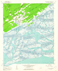
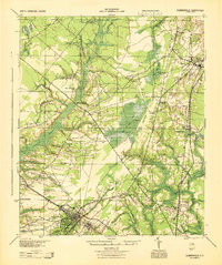
 1944 Ravenels1944 Print · USGSCoastal South Carolina just before the war's end reveals a landscape of tidal rivers and deep-rooted settlements. Trace the footprints of the past at Old Dorchester, locate family homesteads near Poppenheim Crossing, or find long-vanished industry at the Bula Mines.
 - 1944 Map of Summerville
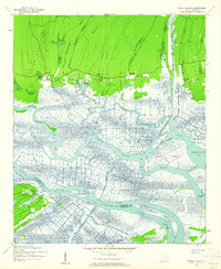
 1944 Summerville1944 Print · USGSThe South Carolina lowcountry near the end of World War II is documented here, showing the rural landscapes of Dorchester and Berkeley counties. Genealogists can trace family roots through numerous local landmarks like Black Tom Sch, St Johns Ch, and Lincolnville.
 - 1944 Map of Wadmelaw Island
 1944 Wadmelaw Island1944 Print · USGSThe South Carolina Lowcountry islands are captured here in the early twentieth century, showing a landscape of tidal creeks and remote coastal settlements. Genealogists can locate family landmarks such as Rockville, Legareville, and several country schools like Bogle School.2 unique versions available
 - 1947 Map of Savannah
 1947 Savannah1947 Print · USGSCoastal Georgia and South Carolina are captured here in the mid-forties, showing the rail-and-river networks of the Lowcountry. Genealogists and researchers can trace old crossroads and river towns from Statesboro to Beaufort, alongside military sites like Camp Stewart and Parris Island.
 - 1948 Map of James Island
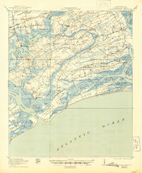
 1948 James Island1948 Print · USGSThe South Carolina coast around the harbor city appeared in this postwar period as a network of naval defenses and established sea island communities. Trace the roads and waterways connecting Charleston to Fort Sumter, Mt Pleasant, and the Isle of Palms.2 unique versions available
Showing maps 1-25 of 30
Top cities of Charleston County
- Mount Pleasant historical maps
- Hollywood historical maps
- Isle of Palms historical maps
- Ravenel historical maps
- Folly Beach historical maps
- Seabrook Island historical maps
See more
Frequently asked questions
- What are the different types of historical maps available for Charleston County?
- What is the oldest map of Charleston County?
- Where can I purchase historical maps of Charleston County for my home or office?
- Where can I download high-res historical maps of Charleston County?
- Are there historical topographic maps available for Charleston County?
- Is there historical aerial imagery available for Charleston County?
- Where are historical maps of Charleston County sourced from?