Old Maps of Charleston County, South Carolina for Hiking & Exploration
Hike through history with 133 historic maps of Charleston County. Explore old trails, ghost towns, and forgotten backroads — perfect for outdoor adventurers and local explorers.
- Rediscover forgotten places: Map out old mining camps, roads, and footpaths that no longer exist on modern maps.
- Layer with modern tools: Combine with LiDAR or satellite views to plan hikes through historical terrain.
- Made for exploration: Popular among hikers, overlanders, and local history lovers.
Use these maps to find adventure and explore the hidden past of Charleston County.
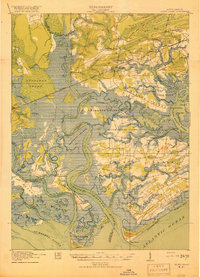
Charleston County, SC maps
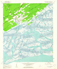
(133)- 1918 Map of Kiawah Island
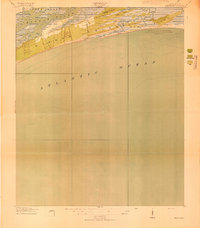 1918 Kiawah Island1918 Print · USGSCovers Charleston County, including Kiawah Island, Johns Island, and other nearby areas2 unique versions available
 - 1918 Map of Cottageville
 1918 Cottageville1918 Print · USGSCovers Charleston County, including Hollywood, Ravenel, and other nearby areas3 unique versions available
 - 1919 Map of Ladson
 1919 Ladson1919 Print · USGSCovers Charleston County, including North Charleston, Summerville, and other nearby areas2 unique versions available
 - 1919 Map of Johns Island
 1919 Johns Island1919 Print · USGSCovers Charleston County, including Charleston, North Charleston, and other nearby areas2 unique versions available
 - 1919 Map of Summerville
 1919 Summerville1919 Print · USGSCovers Charleston County, including Summerville, Goose Creek, and other nearby areas
 - 1919 Map of Edisto Island
 1919 Edisto Island1919 Print · USGSCovers Charleston County, including Hollywood, Meggett, and other nearby areas3 unique versions available
 - 1919 Map of The Jetties
 1919 The Jetties1919 Print · USGSCovers Charleston County, including Charleston, Isle of Palms, and other nearby areas4 unique versions available
 - 1919 Map of Capers Island
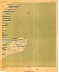
 1919 Capers Island1919 Print · USGSCovers Charleston County, including Isle of Palms, Wild Dunes, and other nearby areas2 unique versions available
 - 1919 Map of Wadmelaw Island
 1919 Wadmelaw Island1919 Print · USGSCovers Charleston County, including Charleston, Hollywood, and other nearby areas2 unique versions available
 - 1919 Map of Wando
 1919 Wando1919 Print · USGSCovers Charleston County, including Charleston, Mount Pleasant, and other nearby areas5 unique versions available
 - 1919 Map of Melgrove
 1919 Melgrove1919 Print · USGSCovers Charleston County, including Charleston, North Charleston, and other nearby areas3 unique versions available
 - 1919 Map of Charleston
 1919 Charleston1919 Print · USGSCovers Charleston County, including Charleston, North Charleston, and other nearby areas3 unique versions available
 - 1919 Map of James Island
 1919 James Island1919 Print · USGSCovers Charleston County, including Charleston, Folly Beach, and other nearby areas2 unique versions available
 - 1919 Map of Fort Moultrie
 1919 Fort Moultrie1919 Print · USGSCovers Charleston County, including Charleston, Mount Pleasant, and other nearby areas3 unique versions available
 - 1919 Map of Bulls Island
 1919 Bulls Island1919 Print · USGSCovers Charleston County, including Awendaw, United States, and other nearby areas3 unique versions available
 - 1919 Map of Sewee Bay
 1919 Sewee Bay1919 Print · USGSCovers Charleston County, including Mount Pleasant, Awendaw, and other nearby areas
 - 1919 Map of Legareville
 1919 Legareville1919 Print · USGSCovers Charleston County, including Charleston, Folly Beach, and other nearby areas2 unique versions available
 - 1920 Map of St. Helena Sound
 1920 St. Helena Sound1920 Print · USGSCovers Charleston County, including Edisto Beach, Cedar Reef Villas, and other nearby areas
 - 1920 Map of Ravenels
 1920 Ravenels1920 Print · USGSCovers Charleston County, including Charleston, North Charleston, and other nearby areas3 unique versions available
 - 1920 Map of Summerville
 1920 Summerville1920 Print · USGSCovers Charleston County, including Summerville, Goose Creek, and other nearby areas3 unique versions available
 - 1940 Map of Melgrove
 1940 Melgrove1940 Print · USGSCovers Charleston County, including Charleston, North Charleston, and other nearby areas
 - 1942 Map of Cape Romain, 1962 Print
 1942 Cape Romain1962 Print · USGSCovers Charleston County, including Georgetown County, United States, and other nearby areas4 unique versions available
 - 1942 Map of Mc Clellanville, 1962 Print
 1942 Mc Clellanville1962 Print · USGSCovers Charleston County, including McClellanville, Moores Corner, and other nearby areas5 unique versions available
 - 1942 Map of Honey Hill, 1962 Print
 1942 Honey Hill1962 Print · USGSCovers Charleston County, including Thompson Corner, Pleasant Hill Landing, and other nearby areas3 unique versions available
 - 1943 Map of Capers Island
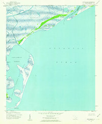
 1943 Capers Island1943 Print · USGSCovers Charleston County, including Isle of Palms, Wild Dunes, and other nearby areas2 unique versions available
Showing maps 1-25 of 133
Top cities of Charleston County
- Mount Pleasant historical maps
- Hollywood historical maps
- Isle of Palms historical maps
- Ravenel historical maps
- Folly Beach historical maps
- Seabrook Island historical maps
See more
Frequently asked questions
- What are the different types of historical maps available for Charleston County?
- What is the oldest map of Charleston County?
- Where can I purchase historical maps of Charleston County for my home or office?
- Where can I download high-res historical maps of Charleston County?
- Are there historical topographic maps available for Charleston County?
- Is there historical aerial imagery available for Charleston County?
- Where are historical maps of Charleston County sourced from?