Old Maps of Charleston County, South Carolina for Academic Research
Study the evolution of Charleston County with 276 high-resolution historic maps. Whether you're teaching, researching, or modeling changes in land use, these maps provide essential visual documentation of urban, environmental, and geographic change.
- Analyze long-term change: Track patterns in development, transportation, and natural features.
- Ideal for environmental or urban studies: Support academic projects with primary historical map data.
- Use in the classroom or lab: Educators and researchers rely on these maps to bring historical context to life.
These maps are a powerful tool for teaching, research, and visualizing how Charleston County has changed over the decades.
Charleston County, SC maps
(276)- 1918 Map of Kiawah Island
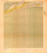 1918 Kiawah Island1918 Print · USGSCoastal South Carolina remains a wilderness of woods and brush during the Great War era. Researchers can trace the early layout of Kiawah Island, identifying landmarks like Avenue Road, Eagle Point, and the eastern tip at Sandy Point.2 unique versions available
 - 1918 Map of Cottageville
 1918 Cottageville1918 Print · USGSThe Lowcountry river basins of Colleton and Dorchester counties are shown here just after the Great War, when the Edisto River was a central geographic divider. Researchers can trace rural life through dozens of named landmarks like Sullivans Church, Metz Store, and Burnt Church Crossroads.3 unique versions available
 - 1919 Map of Ladson
 1919 Ladson1919 Print · USGSThe South Carolina lowcountry is captured here just after the Great War, showing a landscape of riverfront estates and rail-connected settlements. Researchers can trace the grounds of Magnolia Gardens or locate rural centers like Ladson and Otranto.2 unique versions available
 - 1919 Map of Johns Island
 1919 Johns Island1919 Print · USGSCoastal South Carolina at the end of the Great War reveals a landscape of riverfront estates and military remnants. Genealogists and historians can trace family-named stops and rural institutions like Drayton Hall, St Andrews School No 10, and the Bula Mines.2 unique versions available
 - 1919 Map of Summerville
 1919 Summerville1919 Print · USGSSummerville and the surrounding Lowcountry wetlands are captured here just after the Great War, during a period of established rail reliance and rural growth. Genealogists and researchers can trace local landmarks like St Johns Church, the Clemson Coast Express Station, and numerous early school sites including Barrow School.
 - 1919 Map of Edisto Island
 1919 Edisto Island1919 Print · USGSThe South Carolina Lowcountry is depicted here in the years following the Great War, showing a coastal landscape of tidal creeks and island communities. You can trace early 20th-century life through landmarks like Freedman Village, Borough School, and the Old Public Landing.3 unique versions available
 - 1919 Map of The Jetties
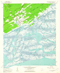
 1919 The Jetties1919 Print · USGSCoastal Charleston and the harbor entrance appear in this military-led survey from the era following the First World War. Maritime historians can trace the engineering of the North Jetty and South Jetty alongside the northern reaches of Morris Island.4 unique versions available
 - 1919 Map of Capers Island
 1919 Capers Island1919 Print · USGSThe barrier islands of Charleston County are shown in fine detail in the years following the Great War. You can trace early 20th-century shorelines and tidal paths through Copahee Sound and locate landmarks like Videl Landing and Alligator Pond.2 unique versions available
 - 1919 Map of Wadmelaw Island
 1919 Wadmelaw Island1919 Print · USGSCoastal South Carolina is mapped here just after the Great War, showing a landscape of sea island plantations and tidal waterways. Researchers can locate remote settlements like Rockville and Legareville, as well as rural landmarks like Crate Mill and St Johns Church.2 unique versions available
 - 1919 Map of Wando
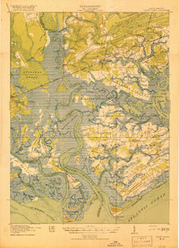
 1919 Wando1919 Print · USGSCoastal Berkeley and Charleston Counties come alive in this survey from just after the Great War. Genealogists can locate family landmarks like St Matthews Church, trace the winding Lumber R. R., or find old river access at Lachicotte Landing.5 unique versions available
 - 1919 Map of Melgrove
 1919 Melgrove1919 Print · USGSThe South Carolina lowcountry emerges in detail during the post-WWI era as industry begins to touch the Cooper River. Genealogists can trace early neighborhood footprints in North Charleston or locate rural landmarks like St.Johns Church and Redbank Landing.3 unique versions available
 - 1919 Map of Charleston
 1919 Charleston1919 Print · USGSCoastal South Carolina thrives at the height of its naval and rail importance in the years following the Great War. Genealogists and historians can trace the development of the Navy Yard and local landmarks like Castle Pinckney and Magnolia Cem.3 unique versions available
 - 1919 Map of James Island
 1919 James Island1919 Print · USGSThe marshlands and small coastal communities of James Island are documented here at the end of the Great War. Genealogists and historians can trace old homesteads and roads through Centerville, find the Payne Chapel, and locate maritime landmarks like the Charleston LH.2 unique versions available
 - 1919 Map of Fort Moultrie
 1919 Fort Moultrie1919 Print · USGSThe Charleston coast at the end of the Great War reveals a landscape of strategic coastal fortifications and early island settlements. Genealogists and historians can trace the layouts of Moultrieville, Mt Pleasant, and the grounds of Fort Moultrie.3 unique versions available
 - 1919 Map of Bulls Island
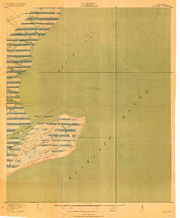 1919 Bulls Island1919 Print · USGSThe Charleston coast appears here just after the Great War, focusing on the isolated marshes and maritime forests of the barrier islands. Researchers can trace the early paths of Bulls Island, including the Old Fort Road and the site of an abandoned lighthouse.3 unique versions available
 - 1919 Map of Sewee Bay
 1919 Sewee Bay1919 Print · USGSThe Charleston County coastline at the end of the Great War reveals a landscape of tidal marshes and interior timber operations. Genealogists can trace the rural school system through Twelvemile School and Eighteenmile School or locate the early footprints of Andersonville and Woodville.
 - 1919 Map of Legareville
 1919 Legareville1919 Print · USGSCoastal Charleston County comes to life in the years following the Great War, showing the intricate salt marshes and islands before modern development. Genealogists can locate family homes and community centers like Legareville, Sandhill School, and Mt Zion Church.2 unique versions available
 - 1920 Map of St. Helena Sound
 1920 St. Helena Sound1920 Print · USGSCoastal South Carolina is captured here in the early twentieth century, showing a labyrinth of marsh and sea islands before the era of modern bridges. Researchers can trace the shifting shoals and original shorelines of Hunting Island, Edisto Island, and St. Helena Island.
 - 1920 Map of Ravenels
 1920 Ravenels1920 Print · USGSThe Ashley River and its surrounding swamps were the heart of this Lowcountry landscape just after the First World War. Researchers can trace the footprints of Old Dorchester, the operations at Bula Mines, and the unique Tyler Tea Farm.3 unique versions available
 - 1920 Map of Summerville
 1920 Summerville1920 Print · USGSThe South Carolina Lowcountry at the close of the Great War reveals a landscape of deep cypress basins and burgeoning rail-side towns. Genealogists can locate numerous rural landmarks like Appii Church, Whitesville School, and the Clemson Coast Experiment Station.3 unique versions available
 - 1940 Map of Melgrove
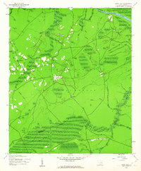
 1940 Melgrove1940 Print · USGSThe South Carolina lowcountry near Charleston appears here just before the mid-century industrial boom. Researchers can locate community anchors like St Johns Ch, the No 6 School, and the rail stop at Inness Sta along the SOUTHERN line.
 - 1942 Map of Cape Romain, 1962 Print
 1942 Cape Romain1962 Print · USGSThe South Carolina coast near the Santee Delta is shown here in the early 1940s, capturing a pristine network of barrier islands and salt marshes. Maritime researchers can trace the historic Intracoastal Waterway and locate landmarks like Lighthouse Island and Deepwater Point.4 unique versions available
 - 1942 Map of Mc Clellanville, 1962 Print
 1942 Mc Clellanville1962 Print · USGSThe South Carolina Lowcountry during the early war years is captured here through the intricate marshes and waterways of the McClellanville coast. Genealogists and historians can trace local landmarks like Lincoln Sch, Rhems Ch, and the outlying Moores Corner settlement.5 unique versions available
 - 1942 Map of Honey Hill, 1962 Print
 1942 Honey Hill1962 Print · USGSBerkeley County was still largely defined by its river-and-swamp geography during the early 1940s. Local researchers can trace old crossroads like Honey Hill and Charley Bridges, or locate river access points including Pleasant Hill Landing and Pitch Landing.3 unique versions available
 - 1943 Map of Capers Island
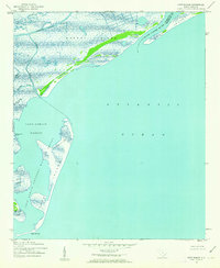
 1943 Capers Island1943 Print · USGSThe South Carolina coast near Charleston appears in high detail during the early 1940s, highlighting the undeveloped barrier islands and complex marsh systems. Maritime researchers can trace historic water passages like Capers Inlet, Price Inlet, and the tidal reaches of the Morgan River.2 unique versions available
Showing maps 1-25 of 276
Top cities of Charleston County
- Mount Pleasant historical maps
- Hollywood historical maps
- Isle of Palms historical maps
- Ravenel historical maps
- Folly Beach historical maps
- Seabrook Island historical maps
See more
Frequently asked questions
- What are the different types of historical maps available for Charleston County?
- What is the oldest map of Charleston County?
- Where can I purchase historical maps of Charleston County for my home or office?
- Where can I download high-res historical maps of Charleston County?
- Are there historical topographic maps available for Charleston County?
- Is there historical aerial imagery available for Charleston County?
- Where are historical maps of Charleston County sourced from?