1970s Maps of Colleton County, South Carolina
Explore 3 historic maps of Colleton County from the 1970s. These maps offer a rare glimpse into what life looked like during the 1970s — showing old roads, neighborhoods, homes, and landmarks that have changed or disappeared over time.
Whether you're researching your family's past, planning a metal detecting trip, or studying how Colleton County's landscape evolved across the 1970s, these high-resolution maps are a powerful tool for exploring the history of this region.
- Focus on a specific era: All maps on this page are from the 1970s, giving you a focused view of this time period.
- See what’s changed: Compare century-old streets, trails, and buildings to today's modern landscape using overlays and satellite layers.
- Research with precision: Use these maps for genealogy, historical research, land use analysis, or educational projects.
- View, download, or print: Maps are fully viewable online in high resolution, and can be downloaded or printed for your own records.
Start exploring Colleton County's history through authentic maps from the 1970s. This is your window into the past.
Colleton County, SC maps
(3)- 1978 Map of Beaufort
 1978 Beaufort1978 Print · USGSCoastal South Carolina and Georgia come to life in this detailed bathymetric study from the late seventies, featuring the intricate Sea Islands and the Savannah River mouth. Researchers can trace military history at Parris Island or locate inland settlements like Switzerland and Old Sheldon.2 unique versions available
 - 1979 Map of Maple Cane Swamp, 1980 Print
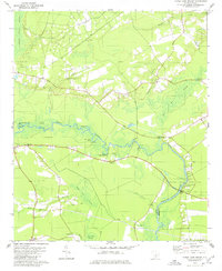 1979 Maple Cane Swamp1980 Print · USGSDorchester and Colleton Counties come together along the river-bottom swamps of the South Carolina Lowcountry in the late seventies. Researchers can locate family burial sites like Muckenfuss Cem and Ferguson Cem or trace river landings such as Mas Old Field Landing.
 - 1979 Map of Jacksonboro, 1980 Print
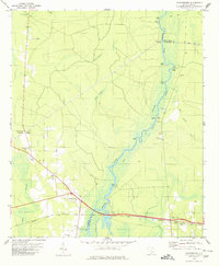 1979 Jacksonboro1980 Print · USGSThe Edisto River Lowcountry in the late seventies reveals a landscape of river landings and remote crossroads at the intersection of three counties. Researchers can trace family history at Buzzard Roost Cem and White Meeting Cem, or locate landmarks like Ponpon and Parkers Ferry Landing.
End of results
Showing maps 1-3 of 3
Top cities of Colleton County
- Walterboro historical maps
- Cottageville historical maps
- Edisto Beach historical maps
- Smoaks historical maps
- Williams historical maps
- Lodge historical maps
Frequently asked questions
- What are the different types of historical maps available for Colleton County?
- What is the oldest map of Colleton County?
- Where can I purchase historical maps of Colleton County for my home or office?
- Where can I download high-res historical maps of Colleton County?
- Are there historical topographic maps available for Colleton County?
- Is there historical aerial imagery available for Colleton County?
- Where are historical maps of Colleton County sourced from?