Old Maps of Colleton County, South Carolina for Metal Detecting
Plan your next treasure hunt with 242 historic maps of Colleton County. Find old homesites, ghost towns, trails, and gathering spots that may be lost to time — perfect for identifying promising metal detecting locations.
- Locate forgotten sites: Uncover places like long-lost settlements, abandoned rail lines, or gathering spots.
- Plan better hunts: Use map overlays combined with LiDAR or satellite views to narrow in on historically rich areas.
- Made for detectorists: Thousands of hobbyists use these maps to discover relics, coins, and hidden history.
Use these historic maps to boost your research and find new opportunities beneath the surface of Colleton County.
Colleton County, SC maps
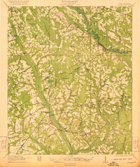
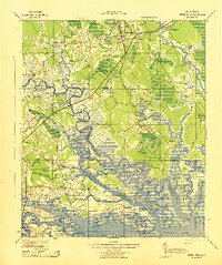
(242)- 1918 Map of Walterboro
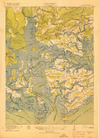
 1918 Walterboro1918 Print · USGSColleton County at the end of the Great War reveals a landscape of river-centered commerce and scattered rural settlements. Family historians can trace ancestral locations through the many churches and schools, such as Catholic Hill, Evergreen Church, and Koger School.4 unique versions available
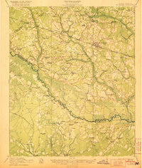
 - 1918 Map of Green Pond
 1918 Green Pond1918 Print · USGSThe South Carolina Lowcountry is captured here just as the First World War ended, showing a landscape defined by the winding Combahee and Ashepoo rivers. Researchers can trace historic family routes along the Old Savannah and Charleston Road and locate rural landmarks like Combahee Ferry and First African Church.4 unique versions available
 - 1918 Map of Varnville
 1918 Varnville1918 Print · USGSCoastal South Carolina is depicted just after the Great War, showing a network of rail-dependent towns and timber operations. Genealogists can trace family roots through numerous local landmarks like Prince William Church, Hampton, and Harrison Sawmill.4 unique versions available
 - 1918 Map of Yemassee
 1918 Yemassee1918 Print · USGSCoastal South Carolina at the end of the Great War reveals a landscape of tidal rivers and emerging rail junctions. Genealogists can trace family locations across Grahams Neck or near historic sites like Pocotaligo, Sheldon, and the logging camps around Gilmania.4 unique versions available
 - 1918 Map of Cottageville
 1918 Cottageville1918 Print · USGSThe Lowcountry river basins of Colleton and Dorchester counties are shown here just after the Great War, when the Edisto River was a central geographic divider. Researchers can trace rural life through dozens of named landmarks like Sullivans Church, Metz Store, and Burnt Church Crossroads.3 unique versions available
 - 1919 Map of Edisto Island
 1919 Edisto Island1919 Print · USGSThe South Carolina Lowcountry is depicted here in the years following the Great War, showing a coastal landscape of tidal creeks and island communities. You can trace early 20th-century life through landmarks like Freedman Village, Borough School, and the Old Public Landing.3 unique versions available
 - 1919 Map of Olar
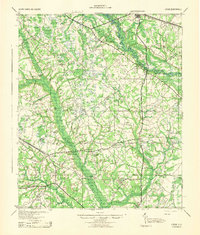
 1919 Olar1919 Print · USGSBamberg and Barnwell counties are shown here just after the Great War, when the river swamps still dictated the path of travel. Genealogists can locate family sites near Hushes Old Mill, Savannah Creek Church, and Stony Bay School.3 unique versions available
 - 1919 Map of Ridgeville
 1919 Ridgeville1919 Print · USGSCoastal South Carolina at the end of the Great War era reveals a landscape of dense swamps and rail-side settlements. Genealogists can trace family roots through numerous local landmarks like Cypress Camp Meeting Grounds, Mudville School, and Limestone Church.
 - 1919 Map of Wadmelaw Island
 1919 Wadmelaw Island1919 Print · USGSCoastal South Carolina is mapped here just after the Great War, showing a landscape of sea island plantations and tidal waterways. Researchers can locate remote settlements like Rockville and Legareville, as well as rural landmarks like Crate Mill and St Johns Church.2 unique versions available
 - 1919 Map of Cummings
 1919 Cummings1919 Print · USGSThe Lowcountry borderlands of Hampton and Colleton counties are captured here just after the Great War, showing a landscape of river-swamps and timber rail lines. Genealogists can trace family roots through dozens of local landmarks like Annie Laurie Church, Ricepatch School, and Bells Crossroads.3 unique versions available
 - 1919 Map of Lodge, 1974 Print
 1919 Lodge1974 Print · USGSCoastal plain life in the early twentieth century is mapped here through its river-reliant settlements and extensive swamp networks. Genealogists can trace family footprints across dozens of local landmarks like Lodge, Smoaks, and Zion Church.
 - 1920 Map of St. Helena Sound
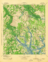
 1920 St. Helena Sound1920 Print · USGSCoastal South Carolina is captured here in the early twentieth century, showing a labyrinth of marsh and sea islands before the era of modern bridges. Researchers can trace the shifting shoals and original shorelines of Hunting Island, Edisto Island, and St. Helena Island.
 - 1920 Map of Lodge
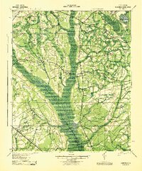
 1920 Lodge1920 Print · USGSColleton and Bamberg counties at the dawn of the 1920s show a landscape of river-bottom farms and rural junctions. Genealogists can trace the location of early country institutions like Hunters Chapel, Tabernacle School, and the rail crossing at Hampton Branch Junction.
 - 1920 Map of Ridgeville
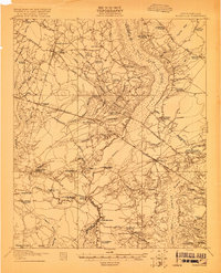
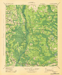
 1920 Ridgeville1920 Print · USGSDorchester County and the surrounding Lowcountry wetlands are captured here just after the Great War, as railroads and swamp crossings defined local life. Trace the old rail lines through Ridgeville and Harleyville or find historic sites like the Two Run Church and Mudville School.3 unique versions available
 - 1920 Map of St. George
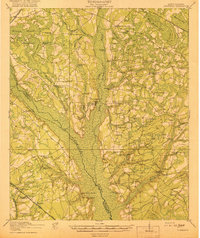
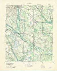
 1920 St. George1920 Print · USGSCoastal plain life in the 1920s centered on the Edisto River and the small railroad towns that bridged the area's vast swamps. Researchers can locate numerous vanished country landmarks, from St James Cemetery to the Cattle Creek School and Independence School.
 - 1921 Map of Lodge
 1921 Lodge1921 Print · USGSThe Salkehatchie and Edisto river basins come alive in this early 1920s survey of the South Carolina Lowcountry. Researchers can trace rural genealogy and old rail lines through local landmarks like Hunters Chapel, Smoaks, and the Hampton and Branchville RR.3 unique versions available
 - 1921 Map of St. George
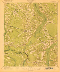
 1921 St. George1921 Print · USGSThe Edisto River valley in the early 1920s was a landscape of small farming hamlets and vital rail connections. Genealogists can trace family roots through numerous sites like Indian Field Campgrounds, St James Cemetery, and the Heaton School.4 unique versions available
 - 1943 Map of Olar
 1943 Olar1943 Print · USGSThe rural Lowcountry around Olar and Ehrhardt appears here during the early 1940s, showing a landscape shaped by river swamps and rail lines. Genealogists can trace family footprints across dozens of sites like Kearse Chapel, Rizers Chapel, and Folk Sch.2 unique versions available
 - 1943 Map of Cottageville
 1943 Cottageville1943 Print · USGSThe South Carolina Lowcountry in the early forties reveals a landscape of river landings and remote crossroads between the Edisto and the swamps. Genealogists can trace family landmarks and school sites like Rehoboth Sch or locate the old Sullivans Ferry crossing.
 - 1943 Map of Edisto Island
 1943 Edisto Island1943 Print · USGSThe South Carolina Lowcountry is captured here in the early 1940s, showing a landscape of tidal islands and rail-side settlements. Researchers can trace the layout of Freedman Village, find old school sites like Seaside Sch, and locate the docks at Steamboat Landing.
 - 1943 Map of Yemassee
 1943 Yemassee1943 Print · USGSThe South Carolina Lowcountry in the early 1940s is defined by its massive tidal rivers and the vital rail junctions at Yemassee. Genealogists and historians can trace old community lines near McPhersonville, Mt Nevo Ch, and the coastal reaches of Seabrook.3 unique versions available
 - 1943 Map of Green Pond
 1943 Green Pond1943 Print · USGSThe Lowcountry river systems of South Carolina are captured here in the 1940s as they wind toward the Atlantic. Genealogists and historians can trace old community ties at First African Ch or locate the Old Fort and rail stops at Ashepoo Siding.2 unique versions available
 - 1943 Map of Lodge
 1943 Lodge1943 Print · USGSThe South Carolina Lowcountry is captured here in the early 1940s at the junction of four counties. Genealogists can trace family roots through numerous rural landmarks like H & B Junction, Hunters Chapel, and the Little Swamp Sch.
 - 1943 Map of Orangeburg
 1943 Orangeburg1943 Print · USGSCoastal plain settlements and river forks define the South Carolina lowcountry during the early war years. Genealogists can trace family landmarks like Bochette Cem, Hunters Chapel Zion Ch, and unique sites like the Indian Field Camp Grounds.
 - 1943 Map of Cummings
 1943 Cummings1943 Print · USGSColleton County's river-and-rail landscape is captured here during the Second World War, showing a network of rural school districts and crossroads. Genealogists can trace family footprints through dozens of local landmarks like Hudsons Mill, Islandton, and Jerusalem Ch.
Showing maps 1-25 of 242
Top cities of Colleton County
- Walterboro historical maps
- Cottageville historical maps
- Edisto Beach historical maps
- Smoaks historical maps
- Williams historical maps
- Lodge historical maps
Frequently asked questions
- What are the different types of historical maps available for Colleton County?
- What is the oldest map of Colleton County?
- Where can I purchase historical maps of Colleton County for my home or office?
- Where can I download high-res historical maps of Colleton County?
- Are there historical topographic maps available for Colleton County?
- Is there historical aerial imagery available for Colleton County?
- Where are historical maps of Colleton County sourced from?