1970s Maps of Orangeburg County, South Carolina
Explore 13 historic maps of Orangeburg County from the 1970s. These maps offer a rare glimpse into what life looked like during the 1970s — showing old roads, neighborhoods, homes, and landmarks that have changed or disappeared over time.
Whether you're researching your family's past, planning a metal detecting trip, or studying how Orangeburg County's landscape evolved across the 1970s, these high-resolution maps are a powerful tool for exploring the history of this region.
- Focus on a specific era: All maps on this page are from the 1970s, giving you a focused view of this time period.
- See what’s changed: Compare century-old streets, trails, and buildings to today's modern landscape using overlays and satellite layers.
- Research with precision: Use these maps for genealogy, historical research, land use analysis, or educational projects.
- View, download, or print: Maps are fully viewable online in high resolution, and can be downloaded or printed for your own records.
Start exploring Orangeburg County's history through authentic maps from the 1970s. This is your window into the past.
Orangeburg County, SC maps
(13)- 1971 Map of Summerton
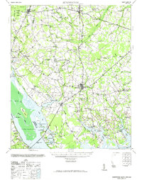 1971 Summerton1971 Print · USGSThe Clarendon County countryside comes alive in this mid-century survey, showing the transition from the Poinsett forest to the shores of Lake Marion. Genealogists can trace family roots through numerous local landmarks like Wells Sch, St Pauls Ch, and the historic Fort Watson.2 unique versions available
 - 1979 Map of Eutawville
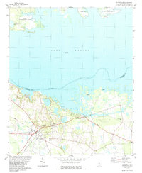 1979 Eutawville1979 Print · USGSThe town of Eutawville sits at the edge of the Santee-Cooper waters during the late 1970s, serving as a hub for the surrounding rural Lowcountry. Genealogists and historians can trace family locations through St James Sch, Mt Pisgah Ch, and the outlying Gaillard settlement.2 unique versions available
 - 1979 Map of Cordova
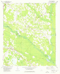
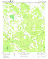
 1979 Cordova1979 Print · USGSThe rural stretches of Orangeburg County are captured here in the late seventies as the town of Cordova developed along the Seaboard Coast Line. Researchers can locate numerous country landmarks like Wesley Grove Ch, the Orangeburg Nat Fish Hatchery, and Simons Siding.2 unique versions available
 - 1979 Map of Norway East
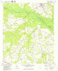
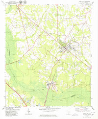
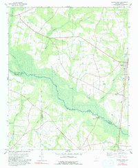
 1979 Norway East1979 Print · USGSThe Orangeburg County countryside in the late 1970s is a landscape of scattered rural settlements and extensive swamp systems. Genealogists and local historians can locate several family-named landmarks and churches, including Bolen Town, Spiers Ch, and the Old Union Cem near the South Fork Edisto River.2 unique versions available
 - 1979 Map of Springfield
 1979 Springfield1979 Print · USGSThe South Carolina Lowcountry comes into focus during the late seventies, centered on the tri-county junction of Aiken, Orangeburg, and Barnwell. Genealogists can locate family landmarks like Frost Branch Ch, the waters of Healing Springs, and the Southern rail corridor.
 - 1979 Map of Eadytown, 1980 Print
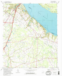
 1979 Eadytown1980 Print · USGSBerkeley County's shoreline and the engineering of the Santee-Cooper project are detailed here in the late seventies. Genealogists and local historians can locate Eadytown, several country churches like Unity Ch, and the historical path of the Santee Canal.2 unique versions available
 - 1979 Map of Midway, 1980 Print
 1979 Midway1980 Print · USGSThe river-laced borderlands of Orangeburg and Bamberg counties are captured here in the late seventies. Family historians can trace rural roots through landmarks like Cana of Galilee Ch, the Southern rail stop at Midway, and the Isaac Jennings Canal.2 unique versions available
 - 1979 Map of Bamberg, 1980 Print
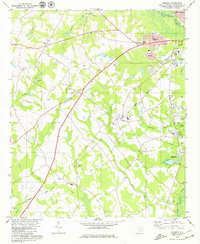
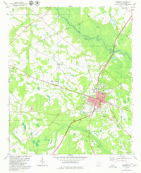 1979 Bamberg1980 Print · USGSBamberg and Denmark thrived at a major rail junction during the late seventies, as the South Carolina Lowcountry balanced agriculture with industry. Genealogists and historians can locate the Carlisle Military Sch, Springtown Ch, and the County Courthouse.2 unique versions available
 - 1979 Map of Holly Hill, 1980 Print
 1979 Holly Hill1980 Print · USGSHolly Hill and the surrounding wetlands of the coastal plain are captured here in the late seventies. Genealogists and historians can locate numerous rural landmarks like Pratt Cem, Union Hill Ch, and the industrial works at Four Holes.2 unique versions available
 - 1979 Map of Sandridge, 1980 Print
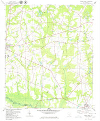
 1979 Sandridge1980 Print · USGSThe rural Lowcountry at the meeting of three counties is captured here in the late seventies. Genealogists and local historians can locate many family-named landmarks and country churches, including Joiner Cem, Tugtown, and Ebenezer Ch.
 - 1979 Map of Cross, 1980 Print
 1979 Cross1980 Print · USGSBerkeley County's rural shoreline and inland Carolina Bays are captured here in the late seventies. Genealogists and local historians can trace family-named landmarks and community hubs like Groomsville Cem, Nelson Hill, and Cross High Sch.2 unique versions available
 - 1979 Map of Vance, 1980 Print
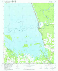
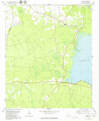
 1979 Vance1980 Print · USGSThe Orangeburg County lakefront and rural interior are captured here in the late seventies. Family historians can locate family-named landmarks like Dantzler-Hart Cem and country steeples such as Mt Pisgah Ch and Liberty Hill Ch.2 unique versions available
 - 1979 Map of Norway West, 1991 Print
 1979 Norway West1991 Print · USGSThe rural landscape of South Carolina's low country is captured here in the late seventies, centered on the railroad town of Norway. Genealogists can trace local roots through numerous country churches and cemeteries like Bushy Pond Ch and Jericho Cem.
End of results
Showing maps 1-13 of 13
Top cities of Orangeburg County
- Orangeburg historical maps
- Holly Hill historical maps
- Bowman historical maps
- Branchville historical maps
- Santee historical maps
- North historical maps
See more
Frequently asked questions
- What are the different types of historical maps available for Orangeburg County?
- What is the oldest map of Orangeburg County?
- Where can I purchase historical maps of Orangeburg County for my home or office?
- Where can I download high-res historical maps of Orangeburg County?
- Are there historical topographic maps available for Orangeburg County?
- Is there historical aerial imagery available for Orangeburg County?
- Where are historical maps of Orangeburg County sourced from?