1980s Maps of Orangeburg County, South Carolina
Explore 23 historic maps of Orangeburg County from the 1980s. These maps offer a rare glimpse into what life looked like during the 1980s — showing old roads, neighborhoods, homes, and landmarks that have changed or disappeared over time.
Whether you're researching your family's past, planning a metal detecting trip, or studying how Orangeburg County's landscape evolved across the 1980s, these high-resolution maps are a powerful tool for exploring the history of this region.
- Focus on a specific era: All maps on this page are from the 1980s, giving you a focused view of this time period.
- See what’s changed: Compare century-old streets, trails, and buildings to today's modern landscape using overlays and satellite layers.
- Research with precision: Use these maps for genealogy, historical research, land use analysis, or educational projects.
- View, download, or print: Maps are fully viewable online in high resolution, and can be downloaded or printed for your own records.
Start exploring Orangeburg County's history through authentic maps from the 1980s. This is your window into the past.
Orangeburg County, SC maps
(23)- 1980 Map of Saint Paul
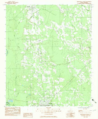
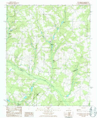
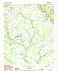
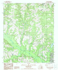
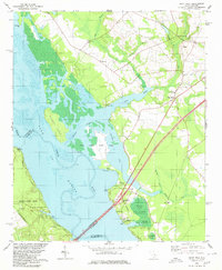 1980 Saint Paul1980 Print · USGSThe Santee River basin is shown here in the early eighties as a hub of conservation and rural heritage. Genealogists and historians can trace local landmarks like St Phillips Ch, the Liberty Hill Sch, and the ancient Indian Mound near Cantey Bay.2 unique versions available
 - 1982 Map of Orangeburg South
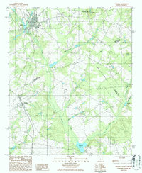
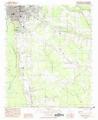 1982 Orangeburg South1982 Print · USGSThe city of Orangeburg and its southern reaches come into focus in the early eighties, showing a landscape defined by education and rail. Researchers can trace the grounds of Claflin College, locate family sites at Sunnyside Cem, or follow the path of the Southern railroad down to Rowesville.2 unique versions available
 - 1982 Map of Branchville South, 1983 Print
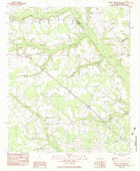
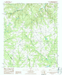
 1982 Branchville South1983 Print · USGSThe Edisto River lowlands were still defined by traditional river crossings and rural church communities in the early 1980s. Researchers can locate family landmarks like Mc Alhany Cem and the river-crossing at Sandy Island Bridge near Branchville.
 - 1982 Map of Felderville, 1983 Print
 1982 Felderville1983 Print · USGSOrangeburg and Calhoun counties in the early eighties are mapped here as a network of rural settlements and extensive wetlands. Researchers can trace family history through local landmarks like Dantzler Sch, Bochette Cem, and the crossroads at Felderville.
 - 1982 Map of Branchville North, 1983 Print
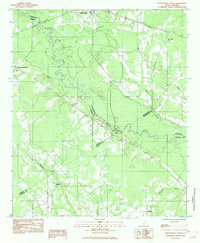
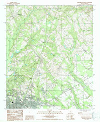
 1982 Branchville North1983 Print · USGSThe rural stretches of Orangeburg County are captured here in the early eighties, centered on the railroad corridor between Rowesville and Branchville. Genealogists can locate several family and church landmarks like Peter Bowman Cem, Byrd Cem, and Cattle Creek Ch.
 - 1982 Map of Reevesville, 1983 Print
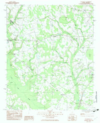
 1982 Reevesville1983 Print · USGSReevesville and the surrounding rural communities of Dorchester County are captured here in the early eighties. Researchers can trace family roots through numerous local landmarks, including Magnolia Cemetery, Sugar Hill, and the tracks of the SOUTHERN railroad.
 - 1982 Map of Indian Camp Branch, 1983 Print
 1982 Indian Camp Branch1983 Print · USGSThe swampy lowlands of the Calhoun and Orangeburg county line come into focus during the early 1980s. Local researchers can locate rural landmarks such as Oaks Crossroads, Brookland Boys Home, and the Pineville Cem amidst the waters of Four Holes Swamp.
 - 1982 Map of Wadboo Swamp, 1983 Print
 1982 Wadboo Swamp1983 Print · USGSOrangeburg and Dorchester Counties are shown in the mid-seventies, where a network of lowland swamps and rural congregations define the local landscape. Researchers can trace the proximity of long-standing community sites like Ebenezer Ch and Rosinville to the sprawling Four Hole Swamp.
 - 1982 Map of Bowman, 1983 Print
 1982 Bowman1983 Print · USGSThe rural town of Bowman and its surrounding wetlands are captured here in the mid-1970s. Researchers can trace local heritage through the placement of Rigby Cem, the High Sch, and rural congregations like Mt Tabor Ch and Prospect Ch.
 - 1982 Map of Barnwell, 1984 Print
 1982 Barnwell1984 Print · USGSCoastal plain settlements and a massive nuclear infrastructure meet in South Carolina during the early eighties. Genealogists and historians can trace rail-town development along the Southern line and explore the footprint of the Savannah River Plant Department of Energy.
 - 1983 Map of Aiken, 1984 Print
 1983 Aiken1984 Print · USGSThe Savannah River valley and South Carolina sandhills are shown in detail during the early eighties, as industry and education expanded. Researchers can trace the rail corridors of the Southern and Seaboard Coast Line through communities like Graniteville and Leesville.
 - 1985 Map of Saint George, 1986 Print
 1985 Saint George1986 Print · USGSThe South Carolina Lowcountry in the mid-eighties shows a landscape defined by the great reservoirs and the meandering Edisto River. Researchers can trace the rail corridors of the Southern Railway and find rural settlements like Harleyville, Smoaks, and Grover.
 - 1986 Map of Pond Branch
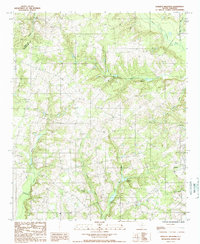
 1986 Pond Branch1986 Print · USGSIn the mid-1980s, the rural borderlands of Lexington and Aiken counties remained a landscape of historic water-powered mills and meandering creeks. Researchers can trace the heritage of local industry at Jeffcoats Millpond, Pooles Millpond, and Kings Pond along the North Fork Edisto River.
 - 1986 Map of Swansea
 1986 Swansea1986 Print · USGSThe tri-county border lands of Lexington, Calhoun, and Orangeburg are captured here in the mid-1980s. Genealogists and local historians can trace the heritage of the milling industry through sites like Etheredge Millpond and Brooker Millpond near Swansea.
 - 1986 Map of Staley Crossroads
 1986 Staley Crossroads1986 Print · USGSIn the mid-1980s, this rural area where three counties meet was a landscape of swamps and family-named ponds. Genealogists and local historians can trace family landholdings near Staley Crossroads and locate small burial sites marked CEM or landmarks like Gressette Pond.
 - 1986 Map of Sumter
 1986 Sumter1986 Print · USGSMid-South Carolina in the mid-eighties reveals a landscape of massive river bottomlands and significant military installations. Genealogists and historians can trace the rural networks around Fort Motte, Lone Star, and Sardinia alongside Lake Marion.
 - 1987 Map of Orangeburg North, 1988 Print
 1987 Orangeburg North1988 Print · USGSThe northern reaches of Orangeburg and the surrounding rural plains are captured in the late eighties just as the city began expanding. Genealogists and local historians can trace family-named areas like Riley, Jamison, and Fersners amidst the reaches of Four Hole Swamp.
 - 1987 Map of Cameron, 1988 Print
 1987 Cameron1988 Print · USGSCoastal plain wetlands and rural settlements define this South Carolina landscape in the late eighties. Researchers can trace family ties and local geography through features like Cameron, the Four Hole Swamp, and the interestingly named Flea Bite Creek.
 - 1988 Map of Elloree
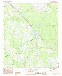
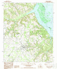 1988 Elloree1988 Print · USGSThe town of Elloree and the western shores of Lake Marion are captured here in the late eighties as the region balanced agriculture with lakeside recreation. Researchers can pinpoint Elloree, the settlement of Lone Star, and several local cemeteries alongside the waters of Santee State Park.
 - 1988 Map of North
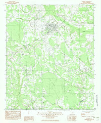
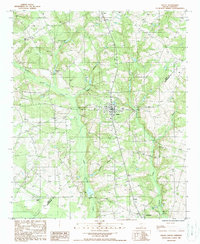
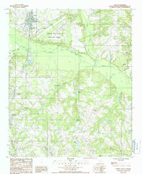 1988 North1988 Print · USGSOrangeburg County's rural heartland is captured here in the late 1980s, centered on the North Fork Edisto River and the town of North. Researchers can trace the layout of Livingston and Neeses or locate family-named sites like Amaker Pond.
 - 1988 Map of Harleys Millpond
 1988 Harleys Millpond1988 Print · USGSOrangeburg and Aiken counties in the late eighties are defined here by a network of rural creek drainages and small-town outposts. Genealogists and local historians can trace family roots through several CEM locations and old water features like Harleys Millpond or Prester Millpond.
 - 1988 Map of Wolfton
 1988 Wolfton1988 Print · USGSIn the late 1980s, the rural landscapes north of Orangeburg reveal a complex network of wetlands and river bends. Genealogists and local historians can trace small settlements like Wolfton and Great Branch alongside landmarks such as Caw Caw Swamp.
 - 1988 Map of Salley
 1988 Salley1988 Print · USGSThe borderlands of Aiken and Orangeburg counties come into focus in the late 1980s, centered on the grid of Salley. Genealogists and historians can trace rural family plots at numerous cemeteries or locate landmarks like Johnsons Pond and Springfield.
End of results
Showing maps 1-23 of 23
Top cities of Orangeburg County
- Orangeburg historical maps
- Holly Hill historical maps
- Bowman historical maps
- Branchville historical maps
- Santee historical maps
- North historical maps
See more
Frequently asked questions
- What are the different types of historical maps available for Orangeburg County?
- What is the oldest map of Orangeburg County?
- Where can I purchase historical maps of Orangeburg County for my home or office?
- Where can I download high-res historical maps of Orangeburg County?
- Are there historical topographic maps available for Orangeburg County?
- Is there historical aerial imagery available for Orangeburg County?
- Where are historical maps of Orangeburg County sourced from?