1980s Maps of Sumter, South Carolina
Explore 3 historic maps of Sumter from the 1980s. These maps offer a rare glimpse into what life looked like during the 1980s — showing old roads, neighborhoods, homes, and landmarks that have changed or disappeared over time.
Whether you're researching your family's past, planning a metal detecting trip, or studying how Sumter's landscape evolved across the 1980s, these high-resolution maps are a powerful tool for exploring the history of this region.
- Focus on a specific era: All maps on this page are from the 1980s, giving you a focused view of this time period.
- See what’s changed: Compare century-old streets, trails, and buildings to today's modern landscape using overlays and satellite layers.
- Research with precision: Use these maps for genealogy, historical research, land use analysis, or educational projects.
- View, download, or print: Maps are fully viewable online in high resolution, and can be downloaded or printed for your own records.
Start exploring Sumter's history through authentic maps from the 1980s. This is your window into the past.
Sumter, SC maps
(3)- 1983 Map of Brogdon
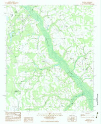 1983 Brogdon1983 Print · USGSThe Pocotaligo River wetlands and the rural communities of Sumter County are frozen in time during the early eighties. Researchers can trace the lineage of local parishes and landmarks like New Bethel Ch, Bradford Cem, and the Seaboard railroad line.
 - 1983 Map of Privateer, 1984 Print
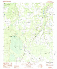 1983 Privateer1984 Print · USGSThe Sumter County countryside comes into focus in the early eighties as a landscape of timber, training ranges, and small crossroads. Genealogists and historians can locate Smith Cem, trace the Seaboard line, or explore Harvins Crossroads.2 unique versions available
 - 1986 Map of Sumter
 1986 Sumter1986 Print · USGSMid-South Carolina in the mid-eighties reveals a landscape of massive river bottomlands and significant military installations. Genealogists and historians can trace the rural networks around Fort Motte, Lone Star, and Sardinia alongside Lake Marion.
End of results
Showing maps 1-3 of 3
Top cities near Sumter
Top neighborhoods of Sumter
- Azalea Trailer Park historical maps
- Ivey Hall historical maps
- Kingman Heights historical maps
- Garris Park historical maps
- Green Acres historical maps
- Marigold Heights historical maps
See more
Frequently asked questions
- What are the different types of historical maps available for Sumter?
- What is the oldest map of Sumter?
- Where can I purchase historical maps of Sumter for my home or office?
- Where can I download high-res historical maps of Sumter?
- Are there historical topographic maps available for Sumter?
- Is there historical aerial imagery available for Sumter?
- Where are historical maps of Sumter sourced from?