1950s Maps of Martin, South Dakota
Explore 13 historic maps of Martin from the 1950s. These maps offer a rare glimpse into what life looked like during the 1950s — showing old roads, neighborhoods, homes, and landmarks that have changed or disappeared over time.
Whether you're researching your family's past, planning a metal detecting trip, or studying how Martin's landscape evolved across the 1950s, these high-resolution maps are a powerful tool for exploring the history of this region.
- Focus on a specific era: All maps on this page are from the 1950s, giving you a focused view of this time period.
- See what’s changed: Compare century-old streets, trails, and buildings to today's modern landscape using overlays and satellite layers.
- Research with precision: Use these maps for genealogy, historical research, land use analysis, or educational projects.
- View, download, or print: Maps are fully viewable online in high resolution, and can be downloaded or printed for your own records.
Start exploring Martin's history through authentic maps from the 1950s. This is your window into the past.
Martin, SD maps
(13)- 1950 Map of Cody, 1952 Print
 1950 Cody1952 Print · USGSCherry County ranching and rail life are at the forefront here in the early fifties as the railroad connects isolated outposts. Researchers can trace historic family lands like the Goodwin Ranch or locate vanished rural schoolhouses such as Crackerbox Sch and School No 60.2 unique versions available
 - 1950 Map of Irwin, 1979 Print
 1950 Irwin1979 Print · USGSThe Nebraska Sandhills and South Dakota borderlands are captured here at mid-century, showing a landscape of isolated ranches and scattered prairie lakes. You can trace the Chicago and North Western rail line and locate rural landmarks like School No 61 and Lions Bridge.
 - 1951 Map of Irwin
 1951 Irwin1951 Print · USGSThe ranching country of northern Nebraska is captured here in the early fifties, just as the Chicago and North Western rail line shaped local commerce. Researchers can locate remote school sites like School No 124 and trace the original Niobrara River crossings at Lions Bridge.
 - 1951 Map of Merriman
 1951 Merriman1951 Print · USGSMerriman and the Cherry County ranchlands are captured here in the early fifties as the railroad and river defined local life. Genealogists and historians can trace family operations like Fairhead Ranch and locate rural landmarks such as Center Cem and School No 76.2 unique versions available
 - 1952 Map of Eli
 1952 Eli1952 Print · USGSThe Niobrara River valley and the surrounding Sand Hills of northern Nebraska are shown here in the early fifties. Local historians can trace the routes of the Chicago and North Western rail line and locate rural sites like Boiling Spring Sch and the Eli Cem.
 - 1955 Map of Hot Springs, 1958 Print
 1955 Hot Springs1958 Print · USGSThe Black Hills and South Dakota badlands are captured here in the mid-fifties, during a peak of military and industrial activity. Researchers can locate the Black Hills Ordnance Depot, early Uranium Mines, and historic rail stops like Pringle or Oglala.5 unique versions available
 - 1955 Map of Alliance, 1966 Print
 1955 Alliance1966 Print · USGSThe Nebraska panhandle comes into sharp focus during the mid-fifties, showing a landscape defined by the Niobrara River and the expanding Sand Hills. Researchers can trace the grounds of Fort Robinson, locate Saint Marys Church, or follow the Chicago Burlington and Quincy rail line through Hemingford.3 unique versions available
 - 1955 Map of Martin, 1968 Print
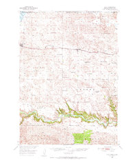
 1955 Martin1968 Print · USGSTribal lands and rail corridors define the South Dakota plains in the mid-fifties, from the sand hills to the badlands. Genealogists and historians can trace the early layout of Pine Ridge Indian Reservation settlements and find small rail towns like Stamford and Witten.2 unique versions available
 - 1957 Map of Alliance
 1957 Alliance1957 Print · USGSNorthwest Nebraska in the mid-fifties is captured here as a landscape of rail hubs, sprawling cattle ranches, and the eastern edge of the dunes. Genealogists and historians can trace rail lines through Alliance and Chadron or locate landmarks like Saint Marys Church and the Agate Spring Fossil Beds.
 - 1957 Map of Valentine, 1960 Print
 1957 Valentine1960 Print · USGSNorthern Nebraska's ranching country and the vast Sand Hills are detailed here in the late fifties. Genealogists and historians can locate numerous family-named landmarks like the Dahlgren Ranch and trace the path of the Chicago and North Western railroad through Valentine.3 unique versions available
 - 1958 Map of Martin
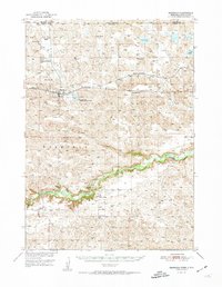
 1958 Martin1958 Print · USGSSouth Dakota's southern plains are documented here in the late fifties, showing the expansive Pine Ridge and Rosebud Indian Reservations. Genealogists and historians can locate early settlements along the Chicago Milwaukee St Paul and Pacific line or find family roots near Martin and the Indian Cemetery.
 - 1958 Map of Alliance
 1958 Alliance1958 Print · USGSNorthwestern Nebraska in the late fifties shows a landscape shaped by the legacy of the high plains frontier and modern agricultural expansion. Genealogists and historians can trace rail-line settlements and landmarks like Fort Robinson and the Agate Spring Fossil Beds.
 - 1959 Map of Valentine
 1959 Valentine1959 Print · USGSThe northern Nebraska Sand Hills are captured here in the late fifties, showcasing a vast ranching landscape shaped by the Niobrara and Loup rivers. Genealogists and historians can trace rail-town development along the Chicago and North Western and locate remote outposts like Brownlee or Kennedy.
End of results
Showing maps 1-13 of 13
Top cities near Martin
Top neighborhoods of Martin
- Tuthill historical maps
- Bad Wound historical maps
- Black Eyes historical maps
- Blackpipe historical maps
- Patricia historical maps
- Harrington historical maps
See more
Frequently asked questions
- What are the different types of historical maps available for Martin?
- What is the oldest map of Martin?
- Where can I purchase historical maps of Martin for my home or office?
- Where can I download high-res historical maps of Martin?
- Are there historical topographic maps available for Martin?
- Is there historical aerial imagery available for Martin?
- Where are historical maps of Martin sourced from?