Old Maps of District 6, South Dakota for Academic Research
Study the evolution of District 6 with 161 high-resolution historic maps. Whether you're teaching, researching, or modeling changes in land use, these maps provide essential visual documentation of urban, environmental, and geographic change.
- Analyze long-term change: Track patterns in development, transportation, and natural features.
- Ideal for environmental or urban studies: Support academic projects with primary historical map data.
- Use in the classroom or lab: Educators and researchers rely on these maps to bring historical context to life.
These maps are a powerful tool for teaching, research, and visualizing how District 6 has changed over the decades.
District 6, SD maps
(161)- 1951 Map of Virginia, 1953 Print
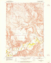
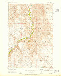 1951 Virginia1953 Print · USGSDewey County’s high prairie and river breaks are captured in the early fifties, showcasing the vital rail corridor through the Cheyenne River Indian Reservation. Researchers can trace the path of the Chicago Milwaukee St Paul and Pacific railroad as it winds alongside Virginia Creek.3 unique versions available
 - 1951 Map of Ridgeview NE, 1953 Print
 1951 Ridgeview NE1953 Print · USGSThe Cheyenne River Indian Reservation is shown in the early fifties during a period of Missouri River Basin development. Researchers can trace rural landmarks like Bauer Sch and the drainage of Swan Creek and the Moreau R.3 unique versions available
 - 1951 Map of La Plant, 1953 Print
 1951 La Plant1953 Print · USGSDewey County’s reservation lands are captured here in the early 1950s, showing a landscape defined by the railroad and the plains. Trace family ties and local history at La Plant or find rural landmarks like Rushs Enemy Cem and the Virgin Creek waterway.
 - 1951 Map of Promise, 1954 Print
 1951 Promise1954 Print · USGSThe rural landscape of Dewey County is captured here in the early fifties, centered on the settlement of Promise. Researchers can trace family roots at St Johns Cem and follow the route of the Chicago Milwaukee St Paul and Pacific railroad.2 unique versions available
 - 1952 Map of Trail City SW, 1954 Print
 1952 Trail City SW1954 Print · USGSDewey County, South Dakota, is captured in the early fifties during a period of Missouri River Basin development. Genealogists and local historians can locate St Marys Ch and trace the complex meanders of the Moreau River and Swan Cr.2 unique versions available
 - 1952 Map of Glencross SE, 1954 Print
 1952 Glencross SE1954 Print · USGSThe Moreau River valley in Dewey County during the early fifties reveals a landscape of isolated missions and river crossings. Genealogists and historians can locate St Pauls Ch, Emmanuel Cem, and the historic Yellowhorse Ford along the winding river banks.2 unique versions available
 - 1953 Map of McIntosh, 1965 Print
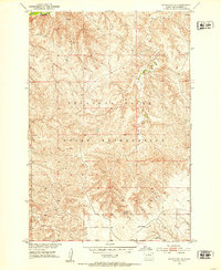
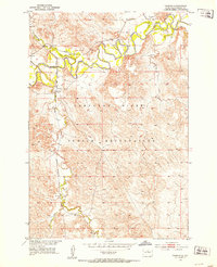
 1953 McIntosh1965 Print · USGSThe north-central Dakota prairie is captured here during the mid-fifties, showing the vast Standing Rock Indian Reservation and the newly formed Oah E Reservoir. Genealogists and historians can trace the Chicago Milwaukee St Paul and Pacific rail line through stops like McIntosh, Walker, and Eagle Butte.3 unique versions available
 - 1954 Map of Pierre, 1968 Print
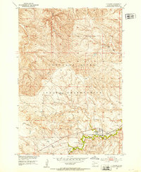
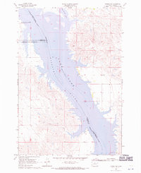
 1954 Pierre1968 Print · USGSThe Missouri River and the newly formed Oahe Reservoir define central South Dakota in the 1950s. Genealogists and local historians can trace early settlements and rail stops like Eakin Siding, Mission Ridge, and Ottumwa.2 unique versions available
 - 1956 Map of Rousseau Creek SW, 1957 Print
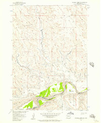 1956 Rousseau Creek SW1957 Print · USGSDewey and Stanley Counties are captured in the mid-1950s just before the landscape was altered by the Missouri River Basin development. Researchers can trace the riverfront holdings of Holloway Ranch, Chisholm Ranch, and the waters of Fishgut Creek.3 unique versions available
 - 1958 Map of Pierre
 1958 Pierre1958 Print · USGSCentral South Dakota is documented during the mid-fifties, just as the Missouri River valley was being transformed by the massive Oahe Dam project. Researchers can trace the early Oahe Reservoir shoreline and find remote outposts like Milesville, Onida, and Giddings Flat.
 - 1958 Map of McIntosh
 1958 McIntosh1958 Print · USGSThe north-central Dakotas appear here in the mid-1950s as massive engineering projects and rail lines shaped the plains. Researchers can trace tribal lands within the Standing Rock Indian Reservation and locate local landmarks like the Keller Mine or the Virginia Siding.
 - 1965 Map of Artichoke Butte SW, 1966 Print
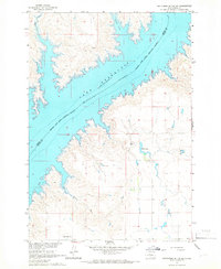 1965 Artichoke Butte SW1966 Print · USGSSully County sits along the rising waters of the Missouri River in the mid-sixties, capturing a landscape in transition. Researchers can trace rural landmarks like Blair Cem or locate the historic Pearl Sch and West Fairbank Sch.
 - 1968 Map of Moreau NW, 1970 Print
 1968 Moreau NW1970 Print · USGSThe Missouri and Moreau River valleys are captured in the late sixties as the landscape adjusted to the rising waters of Lake Oahe. Researchers can trace the shifting shorelines of Lake Missouri and follow the boundary between the Standing Rock and Cheyenne River Indian Reservations.
 - 1968 Map of Moreau NE, 1970 Print
 1968 Moreau NE1970 Print · USGSThe Missouri River breaks of Walworth and Dewey counties appear in the late sixties as the waters of Lake Oahe reshape the valley. Genealogists and researchers can trace the boundaries of the Standing Rock and Cheyenne River reservations or locate the settlement at Ridgeland.
 - 1968 Map of Moreau, 1971 Print
 1968 Moreau1971 Print · USGSThe Moreau River valley within the Cheyenne River Indian Reservation is captured here in the late sixties as Lake Oahe reached its typical levels. Genealogists and historians can locate the Ascension Ch and the settlement of Moreau, along with drainage features like Hokshela Creek.
 - 1968 Map of Moreau SE, 1971 Print
 1968 Moreau SE1971 Print · USGSThe Missouri River breaks and the Cheyenne River Indian Reservation are captured here in the late sixties, just as the landscape was being reshaped by the Oahe reservoir. Researchers can trace the flooded valleys of the Moreau River and locate the Swan Creek Recreation Area and Flowing Well.
 - 1969 Map of Rousseau Creek, 1972 Print
 1969 Rousseau Creek1972 Print · USGSThe Cheyenne River breaks into the Missouri River basin during the late sixties as the reservoir waters reshape the landscape. Trace the shifting shoreline of Lake Oahe and find landmarks like the lone Cem and the winding Rousseau Creek.
 - 1969 Map of No Heart Creek SE, 1972 Print
 1969 No Heart Creek SE1972 Print · USGSThe Missouri River breaks of South Dakota are captured here during the expansion of the Oahe reservoir. Genealogists and historians can trace the Cheyenne River Indian Reservation Boundary and the inlets of Willow Creek Bay and Splits Creek.
 - 1969 Map of Artichoke Butte NW, 1972 Print
 1969 Artichoke Butte NW1972 Print · USGSThe Missouri River Basin undergoes a massive transition in the late sixties as the waters of Lake Oahe rise along the Cheyenne River Indian Reservation Boundary. You can trace the shorelines near Forest City and follow prairie drainages like Pascal Creek and Alberts Creek.
 - 1969 Map of Patch Skin Buttes SW, 1972 Print
 1969 Patch Skin Buttes SW1972 Print · USGSThe Missouri River breaks of South Dakota are shown here in the late sixties, just after the waters of Lake Oahe reshaped the valley. You can trace the Cheyenne River Indian Reservation Boundary and locate local landmarks like Marksville and the Swift Bird Day Sch.
 - 1969 Map of Four Bear Creek, 1972 Print
 1969 Four Bear Creek1972 Print · USGSThe Missouri River breaks into a series of wide bays along the Dewey and Potter county lines during the late sixties. Researchers can trace the flooded reaches of Four Bear Creek and Buck Creek or locate the Indian Reservation Boundary as it stood at this mid-century moment.
 - 1969 Map of No Heart Creek SW, 1972 Print
 1969 No Heart Creek SW1972 Print · USGSThe confluence of the Missouri and Cheyenne rivers in central South Dakota is captured here just as the landscape was transformed by the waters of Lake Oahe. Researchers can trace the Cheyenne River Indian Reservation Boundary and the many inlets formed by No Heart Creek and Tall Prairie Chicken Creek.
 - 1969 Map of Patch Skin Buttes SE, 1972 Print
 1969 Patch Skin Buttes SE1972 Print · USGSPotter County and the Missouri River bluffs are captured here in the late sixties as the newly formed reservoir reshaped the valley. Researchers can trace the submerged riverbanks and locate local landmarks like the Swift Bird Training Center and Forest City.
 - 1970 Map of Patch Skin Buttes, 1972 Print
 1970 Patch Skin Buttes1972 Print · USGSHigh plains terrain and the rising waters of the Missouri River Basin define this Dewey County landscape in the early seventies. Researchers can trace the shoreline of Lake Oahe and locate landmarks like Patch Skin Buttes, Coffee Butte, and Buffalo Creek.
 - 1975 Map of Laundreaux Butte, 1976 Print
 1975 Laundreaux Butte1976 Print · USGSThe South Dakota ridge country comes into focus in the 1970s at the intersection of two major tribal nations. Local historians and genealogists can trace the Standing Rock and Cheyenne River boundaries while locating landmarks like Laundreaux Butte and Flanagan.
Showing maps 1-25 of 161
Top neighborhoods of District 6
- Moreau historical maps
- Promise historical maps
- Ridgeview historical maps
- Marksville historical maps
- La Plant historical maps
- Trail City historical maps
See more
Frequently asked questions
- What are the different types of historical maps available for District 6?
- What is the oldest map of District 6?
- Where can I purchase historical maps of District 6 for my home or office?
- Where can I download high-res historical maps of District 6?
- Are there historical topographic maps available for District 6?
- Is there historical aerial imagery available for District 6?
- Where are historical maps of District 6 sourced from?