1900s (20th Century) Maps of Argentine Township, South Dakota
Explore 9 historic maps of Argentine Township from the 1900s (20th Century). These maps offer a rare glimpse into what life looked like during the 1900s — showing old roads, neighborhoods, homes, and landmarks that have changed or disappeared over time.
Whether you're researching your family's past, planning a metal detecting trip, or studying how Argentine Township's landscape evolved across the 1900s, these high-resolution maps are a powerful tool for exploring the history of this region.
- Focus on a specific era: All maps on this page are from the 1900s, giving you a focused view of this time period.
- See what’s changed: Compare century-old streets, trails, and buildings to today's modern landscape using overlays and satellite layers.
- Research with precision: Use these maps for genealogy, historical research, land use analysis, or educational projects.
- View, download, or print: Maps are fully viewable online in high resolution, and can be downloaded or printed for your own records.
Start exploring Argentine Township's history through authentic maps from the 1900s. This is your window into the past.
Argentine Township, SD maps
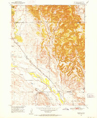
(9)- 1902 Map of Edgemont
 1902 Edgemont1902 Print · USGSThe Black Hills frontier meets the Nebraska plains at the turn of the century, centered on the rail hub of Edgemont. Trace early settlements and rail stops like Minnekahta, Ardmore, and the Quarry as they appeared in this early 1902 survey.4 unique versions available
 - 1950 Map of Burdock, 1952 Print
 1950 Burdock1952 Print · USGSSouth Dakota's river-and-rail frontier is captured here in the early fifties, showing the ranching and irrigation patterns of Fall River County. Genealogists and researchers can locate old sites like Burdock and Marietta, the Burdock Sch, and the Doran Ranch.2 unique versions available
 - 1951 Map of Twentyone Divide, 1953 Print
 1951 Twentyone Divide1953 Print · USGSThe high ridges of the Wyoming and South Dakota border are captured here in the early 1950s. Trace the path of the Chicago Burlington and Quincy railroad or locate the isolated Cheyenne River School and the remote Artesian Well.2 unique versions available
 - 1955 Map of Hot Springs, 1958 Print
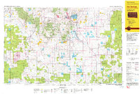
 1955 Hot Springs1958 Print · USGSThe Black Hills and South Dakota badlands are captured here in the mid-fifties, during a peak of military and industrial activity. Researchers can locate the Black Hills Ordnance Depot, early Uranium Mines, and historic rail stops like Pringle or Oglala.5 unique versions available
 - 1955 Map of Newcastle, 1963 Print
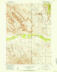
 1955 Newcastle1963 Print · USGSThe high plains of eastern Wyoming and western South Dakota are captured in the mid-fifties, showing a landscape of sprawling ranches and emerging oil fields. Researchers can locate family landmarks like Saunders Ranch, trace the Chicago Burlington & Quincy RR, and explore small rail towns such as Osage and Edgemont.2 unique versions available
 - 1958 Map of Newcastle
 1958 Newcastle1958 Print · USGSThe high plains of eastern Wyoming meet the Black Hills in the late fifties, showcasing a landscape of rail-connected towns and historic trails. Trace the path of the Chicago Burlington & Quincy RR through Newcastle or locate the Bozeman Trail Monument and Summitt Ridge Lookout Tower.
 - 1981 Map of Lance Creek, 1983 Print
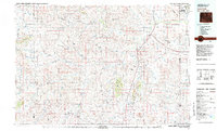 1981 Lance Creek1983 Print · USGSEastern Wyoming at the start of the 1980s reveals a high-plains landscape dominated by the energy industry and complex drainage systems. Researchers can trace the footprints of the Kaye Oil Field and Clareton Oil Field or follow the waters of the Cheyenne River and Robbers Roost Creek.
 - 1985 Map of Hot Springs, 1986 Print
 1985 Hot Springs1986 Print · USGSThe Black Hills meet the southern grasslands in the mid-eighties as this region balances military history with ranching life. Genealogists and historians can trace the foundations of Igloo, locate the National Cem at Hot Springs, or follow the rail lines through Edgemont.2 unique versions available
 - 1993 Map of Hot Springs
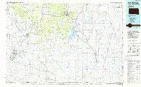
 1993 Hot Springs1993 Print · USGSThe southern Black Hills and Nebraska borderlands are captured here in the late twentieth century, showing a landscape of national forests and grasslands. You can trace the Black Hills Ordnance Depot near Igloo and follow the Burlington Northern rail lines through Edgemont.
End of results
Showing maps 1-9 of 9
Top cities near Argentine Township
Frequently asked questions
- What are the different types of historical maps available for Argentine Township?
- What is the oldest map of Argentine Township?
- Where can I purchase historical maps of Argentine Township for my home or office?
- Where can I download high-res historical maps of Argentine Township?
- Are there historical topographic maps available for Argentine Township?
- Is there historical aerial imagery available for Argentine Township?
- Where are historical maps of Argentine Township sourced from?