
1950 Map of Burdock
USGS Topo · Published 1952About this map
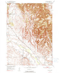
Cheyenne River valley life and high-plains agriculture define this mid-century survey along the border of Fall River and Custer counties. The landscape is marked by a complex network of irrigation infrastructure designed for the Missouri River Basin development, including the Griffis Canal, Angel Canal, and Tubbs Dam. These man-made features contrast with the natural drainage of Beaver Creek and the deep cuts of Bennett Canyon. Local life centers on the small settlements of Burdock and Marietta, each supported by its own schoolhouse, Burdock Sch and Marietta Sch. The Chicago Burlington and Quincy railroad cuts a diagonal path across the terrain, providing a vital link for the isolated ranches such as Doran Ranch. This map records a specific era of South Dakota land management where federal forest boundaries and industrial water projects met the traditional ranching economy.
Find a feature on this map
28 named features on this map. Tap any name to fly to it.
Don’t see what you’re looking for? This feature index may not catch every label — zoom into the map to look around manually.
Map Details
Editions of this 1950 Burdock Map
2 editions found
Other maps of this area

1896 · Harney Peak
USGS Topo · 1:125,000

1899 · Newcastle
USGS Topo · 1:125,000

1901 · Harney Peak
USGS Topo · 1:125,000

1901 · Newcastle
USGS Topo · 1:125,000

1902 · Edgemont
USGS Topo · 1:125,000

1950 · Edgemont
USGS Topo · 1:24,000

1950 · Edgemont SW
USGS Topo · 1:24,000

1950 · Edgemont NE
USGS Topo · 1:24,000

1951 · Dewey
USGS Topo · 1:24,000

1951 · Twentyone Divide
USGS Topo · 1:24,000