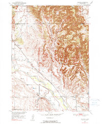
1950 Map of Burdock
USGS Topo · Published 1990About this map
The Cheyenne River valley forms the geographic heart of this mid-century survey, where the Chicago Burlington and Quincy railroad tracks run parallel to an extensive Irrigation Canal network. Life in this ranching landscape centers on small community nodes like Burdock and Marietta, each supported by its own local schoolhouse, Burdock Sch and Marietta Sch.
Find a feature on this map
23 named features on this map. Tap any name to fly to it.
Don’t see what you’re looking for? This feature index may not catch every label — zoom into the map to look around manually.
Map Details
Editions of this 1950 Burdock Map
2 editions found
Other maps of this area

1896 · Harney Peak
USGS Topo · 1:125,000

1899 · Newcastle
USGS Topo · 1:125,000

1901 · Harney Peak
USGS Topo · 1:125,000

1901 · Newcastle
USGS Topo · 1:125,000

1902 · Edgemont
USGS Topo · 1:125,000

1950 · Edgemont
USGS Topo · 1:24,000

1950 · Edgemont SW
USGS Topo · 1:24,000

1950 · Burdock
USGS Topo · 1:24,000

1950 · Edgemont NE
USGS Topo · 1:24,000

1951 · Dewey
USGS Topo · 1:24,000