1930s Maps of Hughes County, South Dakota
Explore 3 historic maps of Hughes County from the 1930s. These maps offer a rare glimpse into what life looked like during the 1930s — showing old roads, neighborhoods, homes, and landmarks that have changed or disappeared over time.
Whether you're researching your family's past, planning a metal detecting trip, or studying how Hughes County's landscape evolved across the 1930s, these high-resolution maps are a powerful tool for exploring the history of this region.
- Focus on a specific era: All maps on this page are from the 1930s, giving you a focused view of this time period.
- See what’s changed: Compare century-old streets, trails, and buildings to today's modern landscape using overlays and satellite layers.
- Research with precision: Use these maps for genealogy, historical research, land use analysis, or educational projects.
- View, download, or print: Maps are fully viewable online in high resolution, and can be downloaded or printed for your own records.
Start exploring Hughes County's history through authentic maps from the 1930s. This is your window into the past.
Hughes County, SD maps
(3)- 1934 Map of Canning
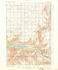
 1934 Canning1934 Print · USGSCentral South Dakota comes to life in the mid-1930s as the Missouri River valley supports a network of ranches and small schools. Genealogists can trace family landmarks like Petrus Ranch or locate local centers including Elm Grove Sch and the Holy Name Chapel.
 - 1937 Map of Canning
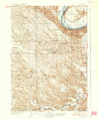
 1937 Canning1937 Print · USGSHughes County ranching and river life are captured here in the mid-1930s as the Missouri River flowed freely past historic islands and rail sidings. Genealogists can locate family landmarks like Pietrus Ranch, Finder Ranch, and numerous country schools such as Pleasantview Sch.3 unique versions available
 - 1937 Map of Oahe
 1937 Oahe1937 Print · USGSStanley County ranching and river life are captured here in the mid-thirties before the Missouri was transformed by modern dams. Genealogists can locate family-named landmarks like Madison Ranch and rural schoolhouses such as Riverview Sch or Willow Creek Butte Sch.3 unique versions available
End of results
Showing maps 1-3 of 3
Top cities of Hughes County
Frequently asked questions
- What are the different types of historical maps available for Hughes County?
- What is the oldest map of Hughes County?
- Where can I purchase historical maps of Hughes County for my home or office?
- Where can I download high-res historical maps of Hughes County?
- Are there historical topographic maps available for Hughes County?
- Is there historical aerial imagery available for Hughes County?
- Where are historical maps of Hughes County sourced from?