1970s Maps of Hughes County, South Dakota
Explore 11 historic maps of Hughes County from the 1970s. These maps offer a rare glimpse into what life looked like during the 1970s — showing old roads, neighborhoods, homes, and landmarks that have changed or disappeared over time.
Whether you're researching your family's past, planning a metal detecting trip, or studying how Hughes County's landscape evolved across the 1970s, these high-resolution maps are a powerful tool for exploring the history of this region.
- Focus on a specific era: All maps on this page are from the 1970s, giving you a focused view of this time period.
- See what’s changed: Compare century-old streets, trails, and buildings to today's modern landscape using overlays and satellite layers.
- Research with precision: Use these maps for genealogy, historical research, land use analysis, or educational projects.
- View, download, or print: Maps are fully viewable online in high resolution, and can be downloaded or printed for your own records.
Start exploring Hughes County's history through authentic maps from the 1970s. This is your window into the past.
Hughes County, SD maps
(11)- 1973 Map of Iron Post Buttes SE
 1973 Iron Post Buttes SE1973 Print · USGSThe Missouri River breaks in the early 1970s reveal a landscape defined by the rising waters of Lake Oahe. Researchers can trace the Old Military Reservation Boundary and locate early recreation sites like the Okobojo Recreation Area and Peoria Flats.
 - 1973 Map of Pierre, 1976 Print
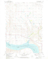
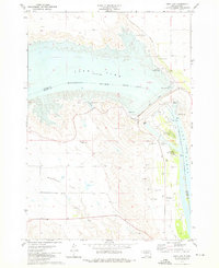
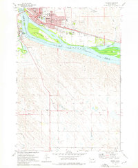 1973 Pierre1976 Print · USGSThe South Dakota capital and Fort Pierre are captured here in the early seventies, flanking the Missouri River at its junction with the Bad River. Genealogists and local historians can trace civic landmarks like the Capitol, the Pierre Indian Sch, and the Riverside Cemetery amidst the river islands and rail lines.
 - 1973 Map of Willow Creek Butte, 1976 Print
 1973 Willow Creek Butte1976 Print · USGSThe Missouri River breaks of Stanley County are captured in the early seventies as the waters of Lake Oahe reshaped the valley. Topographic details reveal the high ground of Willow Creek Butte and the flats at Peoria Flats and Giddings Flat.
 - 1973 Map of De Grey SE, 1976 Print
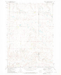
 1973 De Grey SE1976 Print · USGSHughes County in the 1970s is shown as a rural landscape defined by the winding paths of Chapelle Creek and the southern plains. Local history researchers can trace the locations of the Raber Sch, Chapelle Cem, and the Crow Creek Indian Reservation Boundary.
 - 1973 Map of Okobojo SW, 1976 Print
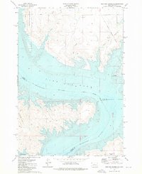
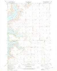 1973 Okobojo SW1976 Print · USGSCentral South Dakota's Missouri River landscape transformed in the early seventies following the filling of the reservoir. Researchers can trace the Old Military Reservation Boundary and locate rural landmarks like the Plainview Sch or Okobojo Creek.
 - 1973 Map of De Grey, 1976 Print
 1973 De Grey1976 Print · USGSHughes County in the 1970s shows the Missouri River bottomlands transformed by the reservoir system of the mid-century. Genealogists and local historians can locate the De Grey Sch, the Ft George Ch, and the rural community of Canning.
 - 1973 Map of Chapelle Lake SW, 1976 Print
 1973 Chapelle Lake SW1976 Print · USGSThe central South Dakota prairie and the Crow Creek Indian Reservation meet here during the mid-1970s. Trace old township life through the Snake Butte Sch, the settlement of Shaber, and landmarks like Pratt Butte.
 - 1973 Map of Antelope Island, 1976 Print
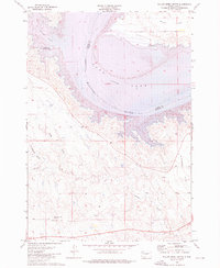
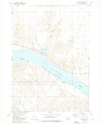
 1973 Antelope Island1976 Print · USGSThe Missouri River corridor south of Pierre is captured in the early 1970s as Lake Sharpe reshaped the landscape. Trace the Old Indian Treaty Boundary and the path of the Chicago and North Western rail line near Alto.
 - 1973 Map of Rousseau, 1976 Print
 1973 Rousseau1976 Print · USGSThe Missouri River breaks across central South Dakota in the 1970s, showcasing the reservoir landscape of Lake Sharpe. Genealogists and historians can trace the Lower Brule Indian Reservation Boundary and locate the Holy Name Chapel or Rousseau Sch.
 - 1973 Map of Oahe Dam, 1976 Print
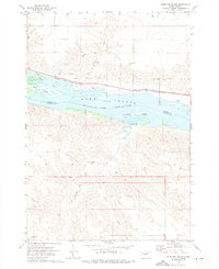
 1973 Oahe Dam1976 Print · USGSStanley and Hughes counties were transformed in the early seventies by the massive Missouri River reservoirs created by the Oahe Dam. Researchers can trace the submerged river boundary and find local landmarks like the Scotty Philip Cem, the Old RR Grade, and Singleton Landing Field.
 - 1973 Map of Chapelle Lake NW, 1976 Print
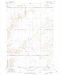
 1973 Chapelle Lake NW1976 Print · USGSThe South Dakota prairie in the early seventies reveals a landscape of rural townships and historical borders. Genealogists and historians can trace the Old Indian Treaty Boundary and explore the drainages of Chapelle Creek near Harrold.
End of results
Showing maps 1-11 of 11
Top cities of Hughes County
Frequently asked questions
- What are the different types of historical maps available for Hughes County?
- What is the oldest map of Hughes County?
- Where can I purchase historical maps of Hughes County for my home or office?
- Where can I download high-res historical maps of Hughes County?
- Are there historical topographic maps available for Hughes County?
- Is there historical aerial imagery available for Hughes County?
- Where are historical maps of Hughes County sourced from?