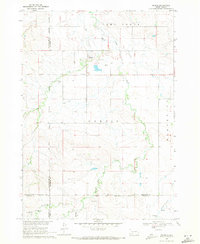
1900s (20th Century) Maps of Wanblee, South Dakota
Explore 25 historic maps of Wanblee from the 1900s (20th Century). These maps offer a rare glimpse into what life looked like during the 1900s — showing old roads, neighborhoods, homes, and landmarks that have changed or disappeared over time.
Whether you're researching your family's past, planning a metal detecting trip, or studying how Wanblee's landscape evolved across the 1900s, these high-resolution maps are a powerful tool for exploring the history of this region.
- Focus on a specific era: All maps on this page are from the 1900s, giving you a focused view of this time period.
- See what’s changed: Compare century-old streets, trails, and buildings to today's modern landscape using overlays and satellite layers.
- Research with precision: Use these maps for genealogy, historical research, land use analysis, or educational projects.
- View, download, or print: Maps are fully viewable online in high resolution, and can be downloaded or printed for your own records.
Start exploring Wanblee's history through authentic maps from the 1900s. This is your window into the past.
Wanblee, SD maps
(25)- 1950 Map of Interior, 1952 Print
 1950 Interior1952 Print · USGSJackson County ranching and rail activity are captured here at mid-century, where the Chicago Milwaukee St Paul and Pacific tracks meet the White River. Trace the era's rural landscape through the location of the Lone Tree Sch. and early Badlands National Monument park features.2 unique versions available
 - 1950 Map of Interior SE, 1952 Print
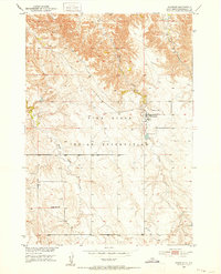
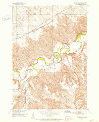
 1950 Interior SE1952 Print · USGSThe Pine Ridge landscape of the early fifties is defined here by the intricate breaks and drainages of the South Dakota badlands. Researchers can trace the winding Bear-in-the-Lodge Creek to find the isolated Headlee Ranch and Garner Sch.3 unique versions available
 - 1950 Map of Potato Creek, 1952 Print
 1950 Potato Creek1952 Print · USGSThe Pine Ridge Indian Reservation in the early fifties shows a landscape of rural schools and winding creek beds. Researchers can trace local history through features like the Bull Cem, Rock Springs Sch, and the small settlement of Potato Creek.2 unique versions available
 - 1950 Map of Wanblee, 1952 Print
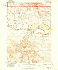
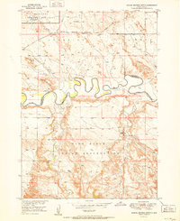
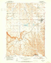
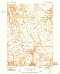
 1950 Wanblee1952 Print · USGSWanblee and the surrounding tribal lands are documented in the early fifties, showing the settlement and rural school system of the day. Genealogists and researchers can locate family sites near Gethsemane Cem, St Ignatius Cem, and Eagle Nest Sch.3 unique versions available
 - 1951 Map of Wanblee NW
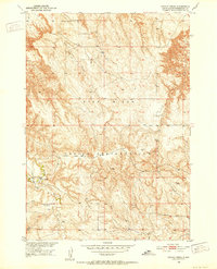
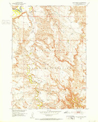
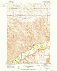
 1951 Wanblee NW1951 Print · USGSThe Pine Ridge region of South Dakota is captured here in the early fifties, documenting the winding White River and the rural infrastructure of the era. Genealogists and researchers can trace local landmarks like Weta Sch and a river Ford near the historic Washabaugh Co line.3 unique versions available
 - 1951 Map of School Section Butte
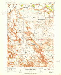
 1951 School Section Butte1951 Print · USGSThe northern edge of the Oglala Lakota lands meets the river-cut badlands in the early fifties. Genealogists and historians can locate the Craven Ranch and trace the winding White River between School Section Butte and the Pine Ridge Indian Reservation.2 unique versions available
 - 1951 Map of Pass Creek NW, 1952 Print
 1951 Pass Creek NW1952 Print · USGSJackson County ranchlands and the northern border of the Pine Ridge Indian Reservation are documented here in the early fifties. Genealogists and land historians can locate isolated homesteads like Pettijohn Ranch and Rock Ranch along the banks of Pass Creek.2 unique versions available
 - 1951 Map of Stamford SW, 1952 Print
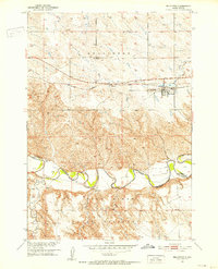
 1951 Stamford SW1952 Print · USGSSouth Dakota's river breaks and high plateaus are captured here in the early fifties, showing the rural landscape south of the Milwaukee Road. Genealogists and local historians can locate Valley Sch (Abandoned), Six School, and the winding course of the White River.3 unique versions available
 - 1951 Map of Belvidere, 1952 Print
 1951 Belvidere1952 Print · USGSIn the early 1950s, this area of South Dakota shows a landscape centered on the Chicago Milwaukee St Paul and Pacific rail line. Researchers can trace the White River Reservation Boundary and locate local sites like Willert Sch and the Belvidere Cem.2 unique versions available
 - 1951 Map of Kadoka, 1952 Print
 1951 Kadoka1952 Print · USGSKadoka stood as a vital prairie crossroads in the early fifties, where the railroad and regional highways met the edge of the reservation. Genealogists can trace family landmarks like Franklin Sch, the local Cem, and the tracks of the Chicago Milwaukee St Paul and Pacific.2 unique versions available
 - 1951 Map of Belvidere SW, 1952 Print
 1951 Belvidere SW1952 Print · USGSThe White River country of Jackson and Washabaugh Counties is shown here in the early fifties, where the White River meets the Pine Ridge Indian Reservation. Researchers can trace old family holdings like Word Ranch and rural landmarks such as Flat Top Sch and the Landing Field.2 unique versions available
 - 1951 Map of Cedar Butte NW, 1953 Print
 1951 Cedar Butte NW1953 Print · USGSNative American ranching and early community life in Mellette County come into focus during the early fifties. Genealogists and historians can trace family locations at Walker Ranch and the Church Creek Ch Cem near the Black Pipe Creek crossing.2 unique versions available
 - 1951 Map of Wanblee NE, 1953 Print
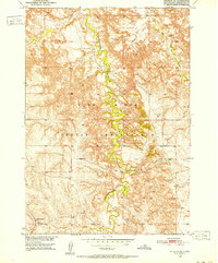
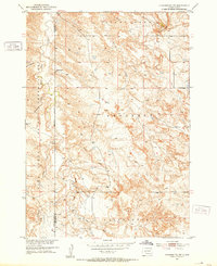
 1951 Wanblee NE1953 Print · USGSThe Pine Ridge Indian Reservation landscape is captured here in the early fifties, showing the rugged breaks south of the White River. Researchers can trace old rural infrastructure like the Wells Sch (Abandoned) and landmarks such as Kodak Point and the Pass Creek Basin.3 unique versions available
 - 1951 Map of Pass Creek NE, 1953 Print
 1951 Pass Creek NE1953 Print · USGSThe Pine Ridge Indian Reservation is shown in the early 1950s, highlighting the transition between the high flats and the broken basins. Researchers can trace the rugged drainage of Red Stone Basin and locate early stock water sources like Red Rock Pond and Corral Pond.
 - 1955 Map of Martin, 1968 Print
 1955 Martin1968 Print · USGSTribal lands and rail corridors define the South Dakota plains in the mid-fifties, from the sand hills to the badlands. Genealogists and historians can trace the early layout of Pine Ridge Indian Reservation settlements and find small rail towns like Stamford and Witten.2 unique versions available
 - 1958 Map of Martin
 1958 Martin1958 Print · USGSSouth Dakota's southern plains are documented here in the late fifties, showing the expansive Pine Ridge and Rosebud Indian Reservations. Genealogists and historians can locate early settlements along the Chicago Milwaukee St Paul and Pacific line or find family roots near Martin and the Indian Cemetery.
 - 1969 Map of Norris, 1971 Print
 1969 Norris1971 Print · USGSMellette County and the Rosebud Indian Reservation come into focus during the late sixties as the community of Norris anchors this prairie landscape. Genealogists and local historians can trace family ties at Poor Thunder Cem, St Stephens Ch, and Red Leaf Cem along the Black Pipe Creek valley.
 - 1980 Map of Kadoka
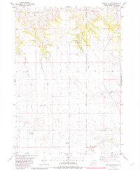
 1980 Kadoka1980 Print · USGSWestern South Dakota's open plains and Badlands are captured here in the early eighties, showcasing a region defined by its railroads and reservations. Researchers can trace the routes of the Chicago and North Western or locate local landmarks like Kadoka Lake and Wanblee.
 - 1981 Map of Cedar Butte
 1981 Cedar Butte1981 Print · USGSThe South Dakota prairie at the start of the eighties is captured here, detailing the rural landscape of Mellette and Jackson counties. Local researchers can trace family landmarks and community sites like Stands For Them Cem, Running Bird Sch, and St Thomas Ch.
 - 1981 Map of Long Valley
 1981 Long Valley1981 Print · USGSWestern South Dakota's open range is captured here in the early eighties, showing the interface between Jackson County and the Pine Ridge Indian Reservation. Researchers can locate the Hawkwing Cemetery, the Rodeo Ground, and the small settlement of Long Valley.
 - 1981 Map of Broken Leg Dam
 1981 Broken Leg Dam1981 Print · USGSThe Pine Ridge Indian Reservation in Jackson County is shown here in the mid-1970s, as ranching and water management shaped the landscape. Researchers can trace local infrastructure through features like Broken Leg Dam, Poor Bear Lake, and the curiously named Up Settin Creek.
 - 1981 Map of Short Bow Creek
 1981 Short Bow Creek1981 Print · USGSJackson County ranchlands and reservation territory are captured here during the early eighties. Genealogists and historians can trace the essential water sources of the prairie, from Hooks Spring to landmarks like Half Dome and Berry Dam.
 - 1981 Map of Hisle
 1981 Hisle1981 Print · USGSThe Pine Ridge Indian Reservation and the rural landscapes of Jackson County are captured in this early 1980s survey. Genealogists can locate St Joseph Cem and trace the small community of Hisle along the banks of Bear-in-the-Lodge Creek.
 - 1981 Map of Buzzard Butte
 1981 Buzzard Butte1981 Print · USGSThe Pine Ridge Indian Reservation in Jackson and Bennett counties is captured here in the early eighties as a landscape of dramatic buttes and winding creeks. Genealogists and historians can trace the paths of Bear-in-the-Lodge Creek and landmarks like Eagle Nest Butte.
 - 1983 Map of Martin
 1983 Martin1983 Print · USGSBennett County and the neighboring tribal lands appear here in the early eighties as a network of High Plains settlements and conservation areas. Researchers can trace tribal boundaries and local genealogy through sites like Pine Ridge Indian Reservation, Long Valley, and Arnold Ranch.
End of results
Showing maps 1-25 of 25
Top cities near Wanblee
Top neighborhoods of Wanblee
Frequently asked questions
- What are the different types of historical maps available for Wanblee?
- What is the oldest map of Wanblee?
- Where can I purchase historical maps of Wanblee for my home or office?
- Where can I download high-res historical maps of Wanblee?
- Are there historical topographic maps available for Wanblee?
- Is there historical aerial imagery available for Wanblee?
- Where are historical maps of Wanblee sourced from?