1960s Maps of St. Francis Segment, South Dakota
Explore 6 historic maps of St. Francis Segment from the 1960s. These maps offer a rare glimpse into what life looked like during the 1960s — showing old roads, neighborhoods, homes, and landmarks that have changed or disappeared over time.
Whether you're researching your family's past, planning a metal detecting trip, or studying how St. Francis Segment's landscape evolved across the 1960s, these high-resolution maps are a powerful tool for exploring the history of this region.
- Focus on a specific era: All maps on this page are from the 1960s, giving you a focused view of this time period.
- See what’s changed: Compare century-old streets, trails, and buildings to today's modern landscape using overlays and satellite layers.
- Research with precision: Use these maps for genealogy, historical research, land use analysis, or educational projects.
- View, download, or print: Maps are fully viewable online in high resolution, and can be downloaded or printed for your own records.
Start exploring St. Francis Segment's history through authentic maps from the 1960s. This is your window into the past.
St. Francis Segment, SD maps
(6)- 1969 Map of Olsonville NW, 1972 Print
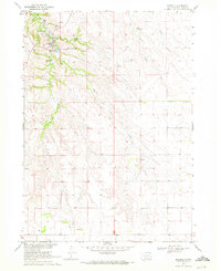
 1969 Olsonville NW1972 Print · USGSTodd County, South Dakota is mapped in the late sixties, showing the vital relationship between the land and its water sources within the Rosebud Indian Reservation. Genealogists and historians can trace field boundaries and vital water points like Antelope Creek, Well, and Spring.
 - 1969 Map of Rosebud, 1972 Print
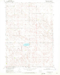
 1969 Rosebud1972 Print · USGSThe community of Rosebud is shown in detail during the late 1960s as the heart of the Rosebud Indian Reservation. Researchers can locate significant landmarks including the Spotted Tail Cem, the Paulhamous Landing Area, and Indian Scout Lake.
 - 1969 Map of St. Francis SW, 1972 Print
 1969 St. Francis SW1972 Print · USGSThe Rosebud Indian Reservation borderlands are captured here in the late sixties as they span the state line into Nebraska. Researchers can trace family history at the Star Cem or locate the Sacred Heart Ch near the banks of Bull Creek.
 - 1969 Map of Olsonville SW, 1972 Print
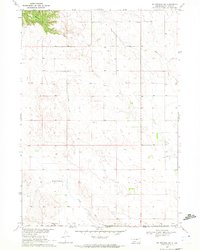
 1969 Olsonville SW1972 Print · USGSThe South Dakota-Nebraska borderlands within the Rosebud Indian Reservation are shown in detail during the late sixties. Genealogists can locate legacy sites like Lakeview Cem, St Agnes Cem, and the community of Lakeview.
 - 1969 Map of St. Francis, 1972 Print
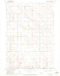
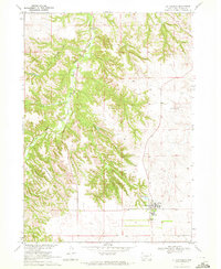 1969 St. Francis1972 Print · USGSThe Rosebud Indian Reservation in the late sixties is centered here on the settlement of St Francis. Researchers can trace the community layout of the time through the Mission Sch, Immaculate Conception Ch, and the rugged topography of Crazy Horse Canyon.
 - 1969 Map of St. Francis SE, 1972 Print
 1969 St. Francis SE1972 Print · USGSTodd County during the late sixties reveals the intersection of tribal lands and the state line on the Great Plains. Researchers can trace the Rosebud Indian Reservation Boundary and locate family sites near Pure Water Cem or Bull Creek.
End of results
Showing maps 1-6 of 6
Top cities near St. Francis Segment
Top neighborhoods of St. Francis Segment
Frequently asked questions
- What are the different types of historical maps available for St. Francis Segment?
- What is the oldest map of St. Francis Segment?
- Where can I purchase historical maps of St. Francis Segment for my home or office?
- Where can I download high-res historical maps of St. Francis Segment?
- Are there historical topographic maps available for St. Francis Segment?
- Is there historical aerial imagery available for St. Francis Segment?
- Where are historical maps of St. Francis Segment sourced from?