1960s Maps of Walworth County, South Dakota
Explore 11 historic maps of Walworth County from the 1960s. These maps offer a rare glimpse into what life looked like during the 1960s — showing old roads, neighborhoods, homes, and landmarks that have changed or disappeared over time.
Whether you're researching your family's past, planning a metal detecting trip, or studying how Walworth County's landscape evolved across the 1960s, these high-resolution maps are a powerful tool for exploring the history of this region.
- Focus on a specific era: All maps on this page are from the 1960s, giving you a focused view of this time period.
- See what’s changed: Compare century-old streets, trails, and buildings to today's modern landscape using overlays and satellite layers.
- Research with precision: Use these maps for genealogy, historical research, land use analysis, or educational projects.
- View, download, or print: Maps are fully viewable online in high resolution, and can be downloaded or printed for your own records.
Start exploring Walworth County's history through authentic maps from the 1960s. This is your window into the past.
Walworth County, SD maps
(11)- 1967 Map of Glenham, 1968 Print
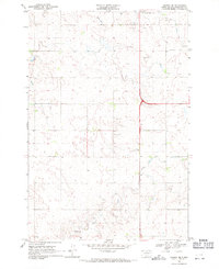
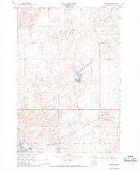 1967 Glenham1968 Print · USGSWalworth County in the late sixties reveals a landscape transformed by the Missouri River's damming and the steady pulse of the rail line. Genealogists and researchers can trace the rural Habenberg Sch, the rail siding at Ridgeland, and the shoreline of the Oahe Reservoir.
 - 1967 Map of Selby SW, 1969 Print
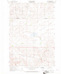 1967 Selby SW1969 Print · USGSWalworth County and Campbell County are captured here in the late sixties as a landscape of rail-served prairie settlements and isolated schoolhouses. Researchers can trace the path of the Chicago Milwaukee St Paul and Pacific through Sitka or locate the Lund Sch and Lindbergh Sch.
 - 1967 Map of Selby, 1969 Print
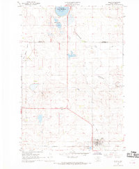 1967 Selby1969 Print · USGSWalworth and Campbell Counties show their agricultural and rail roots in the late sixties. Genealogists and local historians can trace the foundations of the community through sites like Bethany Cemetery, Monroe School, and the Selby rail corridor.
 - 1967 Map of Mobridge, 1969 Print
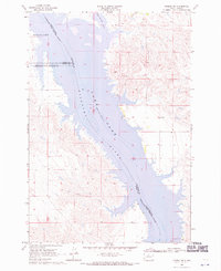
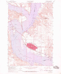 1967 Mobridge1969 Print · USGSMobridge and the Missouri River corridor are captured here during the late sixties as the reservoir transformed the regional landscape. Researchers can locate Sitting Bulls Grave, trace the Chicago Milwaukee St Paul and Pacific rail line, and find local landmarks like Greenwood Cem or Beadle Sch.2 unique versions available
 - 1968 Map of Moreau NE, 1970 Print
 1968 Moreau NE1970 Print · USGSThe Missouri River breaks of Walworth and Dewey counties appear in the late sixties as the waters of Lake Oahe reshape the valley. Genealogists and researchers can trace the boundaries of the Standing Rock and Cheyenne River reservations or locate the settlement at Ridgeland.
 - 1968 Map of Akaska NW, 1971 Print
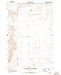 1968 Akaska NW1971 Print · USGSWalworth County prairies are shown at the end of the 1960s, documenting a remote landscape of section-line roads and rural boundaries. Researchers can locate the Pershing Sch and a local Gravel Pit among the hills and draws.
 - 1968 Map of Akaska SW, 1971 Print
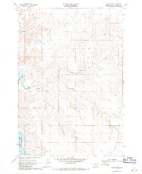 1968 Akaska SW1971 Print · USGSWalworth County, South Dakota, was transitioning in the late 1960s as the Missouri River valley adjusted to the presence of Lake Oahe. Researchers can trace the path of the Old Railroad Grade and locate family history at Old Zion Cem near Swan Creek.
 - 1968 Map of Akaska, 1971 Print
 1968 Akaska1971 Print · USGSAkaska and the rolling plains of Walworth County are documented here in the late sixties, showing a landscape defined by prairie agriculture. You can trace the path of the Old Railroad Grade and locate family landmarks like the Akaska Cem and Rieger Creek.
 - 1968 Map of Moreau SE, 1971 Print
 1968 Moreau SE1971 Print · USGSThe Missouri River breaks and the Cheyenne River Indian Reservation are captured here in the late sixties, just as the landscape was being reshaped by the Oahe reservoir. Researchers can trace the flooded valleys of the Moreau River and locate the Swan Creek Recreation Area and Flowing Well.
 - 1968 Map of Akaska NE, 1971 Print
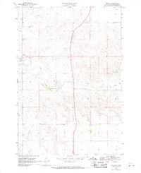
 1968 Akaska NE1971 Print · USGSWalworth County settlement and rural infrastructure are captured here in the late sixties as the area around Selby continued to develop. Researchers can locate family sites and local landmarks like Selby Union Cem, Bangor Cem, and the Rabenberg Airport.
 - 1969 Map of Four Bear Creek, 1972 Print
 1969 Four Bear Creek1972 Print · USGSThe Missouri River breaks into a series of wide bays along the Dewey and Potter county lines during the late sixties. Researchers can trace the flooded reaches of Four Bear Creek and Buck Creek or locate the Indian Reservation Boundary as it stood at this mid-century moment.
End of results
Showing maps 1-11 of 11
Top cities of Walworth County
- Mobridge historical maps
- Selby historical maps
- Java historical maps
- Glenham historical maps
- Akaska historical maps
- Lowry historical maps
Frequently asked questions
- What are the different types of historical maps available for Walworth County?
- What is the oldest map of Walworth County?
- Where can I purchase historical maps of Walworth County for my home or office?
- Where can I download high-res historical maps of Walworth County?
- Are there historical topographic maps available for Walworth County?
- Is there historical aerial imagery available for Walworth County?
- Where are historical maps of Walworth County sourced from?