1940s Maps of Bedford County, Tennessee
Explore 17 historic maps of Bedford County from the 1940s. These maps offer a rare glimpse into what life looked like during the 1940s — showing old roads, neighborhoods, homes, and landmarks that have changed or disappeared over time.
Whether you're researching your family's past, planning a metal detecting trip, or studying how Bedford County's landscape evolved across the 1940s, these high-resolution maps are a powerful tool for exploring the history of this region.
- Focus on a specific era: All maps on this page are from the 1940s, giving you a focused view of this time period.
- See what’s changed: Compare century-old streets, trails, and buildings to today's modern landscape using overlays and satellite layers.
- Research with precision: Use these maps for genealogy, historical research, land use analysis, or educational projects.
- View, download, or print: Maps are fully viewable online in high resolution, and can be downloaded or printed for your own records.
Start exploring Bedford County's history through authentic maps from the 1940s. This is your window into the past.
Bedford County, TN maps
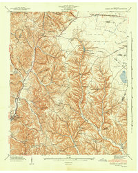
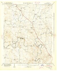
(17)- 1941 Map of Ovoca, 1943 Print
 1941 Ovoca1943 Print · USGSCoffee County in the early 1940s reflects a rural landscape undergoing rapid change as the military expanded its footprint. Genealogists can locate family-named crossings like Richardson Ford and local landmarks such as the Ovoca Orphans Home or Hickerson Station.2 unique versions available
 - 1941 Map of Cumberland Springs, 1943 Print
 1941 Cumberland Springs1943 Print · USGSMoore County and the Highland Rim are captured in the early 1940s, just as the nearby military expansion began to transform the local landscape. Genealogists can trace family footprints through community sites like Lynchburg, Bakertown, and Hickory Hill Sch.5 unique versions available
 - 1943 Map of Mc Minnville, 1944 Print
 1943 Mc Minnville1944 Print · USGSMid-Tennessee is captured here during the mobilization of the early 1940s, showing the vast Camp Forrest Military Reservation and thriving rail towns. Trace the N C & ST L line through Mcminnville or locate smaller rural hubs like Morrison and Hickerson Station.
 - 1944 Map of Shelbyville
 1944 Shelbyville1944 Print · USGSMid-century Middle Tennessee is captured here during the wartime mobilization of the 1940s. Genealogists and researchers can trace family lands near Bugscuffle, Shelbyville Mills, and the expansive Camp Forrest Military Res.
 - 1947 Map of Farmington, 1948 Print
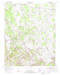
 1947 Farmington1948 Print · USGSThe Duck River and the Louisville and Nashville RR shape this Marshall County landscape in the late 1940s. Genealogists can locate family names at Wilhoite Cem or trace the river at White Ford and Wilhoite Mills.4 unique versions available
 - 1947 Map of Bedford, 1948 Print
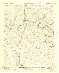
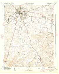
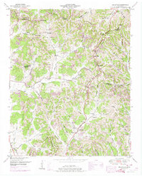
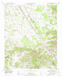
 1947 Bedford1948 Print · USGSThe rural landscape of Middle Tennessee is captured here in the late 1940s, highlighting a network of small farming settlements and river crossings. Researchers can trace family history through sites like Temple Ford, Richmond Ch, and the numerous community burial grounds like Gaunt Cem.6 unique versions available
 - 1947 Map of Normandy, 1948 Print
 1947 Normandy1948 Print · USGSBedford and Moore Counties are captured here shortly after the war, when the Duck River still powered local industry. Genealogists can trace family names across Cortner Cem and Ledfords Mill or locate rural landmarks like Shoffner Ch.7 unique versions available
 - 1947 Map of Unionville, 1948 Print
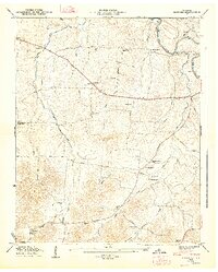
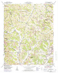
 1947 Unionville1948 Print · USGSBedford County's rural heartland is captured here in the late 1940s, centered on the historic crossroads of Unionville. Researchers can trace the mid-century river economy along the Duck River, finding local landmarks like Halls Mill, Anchor Mill, and Warner Bridge.5 unique versions available
 - 1947 Map of Shelbyville, 1948 Print
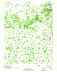
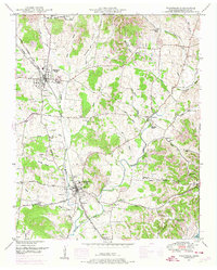
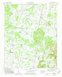
 1947 Shelbyville1948 Print · USGSMid-century Bedford County reveals a landscape shaped by the winding Duck River and the industrial activity of Shelbyville Mills. Genealogists and local historians can trace rural roots through Mullins Chapel, Flat Creek Sch, and family burial sites like Rosebank Cem.2 unique versions available
 - 1949 Map of Rover, 1966 Print
 1949 Rover1966 Print · USGSIn the late 1940s, the rural border between Rutherford and Bedford counties remained a landscape of family farms and country crossroads. Researchers can trace ancestral locations like Puckett Store, the Vernon Corner School, and family-named landmarks like Putman Well.3 unique versions available
 - 1949 Map of Chapel Hill, 1966 Print
 1949 Chapel Hill1966 Print · USGSMid-century Middle Tennessee comes to life here as the rail-and-road network connects rural Marshall and Rutherford counties. Genealogists can trace family landmarks across dozens of sites like Riggs Chapel, Holtland (PO), and the Marrs Hill Cem.2 unique versions available
 - 1949 Map of Belleville, 1974 Print
 1949 Belleville1974 Print · USGSLincoln County was a landscape of high ridges and deep hollows in the years following the war, centered around the community of Belleville. Researchers can trace old family burial grounds and country parishes like Hickory Hill Church and Wylie Cemetery.2 unique versions available
 - 1949 Map of Booneville, 1974 Print
 1949 Booneville1974 Print · USGSMoore County and the surrounding ridges come to life in this mid-century survey of the region around the Lynchburg distillery country. Genealogists can trace family footprints across dozens of named hollows and remote burial sites like Shoffner Cem and Cox Cem.2 unique versions available
 - 1949 Map of Wartrace, 1974 Print
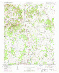
 1949 Wartrace1974 Print · USGSThe rail crossroads of Middle Tennessee are captured here as the postwar era begins. Genealogists can trace family heritage through sites like Webb School, Bethsalem Cem, and the small community of Kellertown.2 unique versions available
 - 1949 Map of Belfast, 1975 Print
 1949 Belfast1975 Print · USGSMarshall County in the late nineteen-forties is a landscape of rural schoolhouses and family cemeteries connected by the Louisville and Nashville RR. Genealogists can trace family lines near Belfast through local landmarks like Temple Cem and Cedar Grove School.2 unique versions available
 - 1949 Map of Webbs Jungle, 1975 Print
 1949 Webbs Jungle1975 Print · USGSRutherford and Bedford Counties appear in the late 1940s as a landscape of river-bottom farms and ridge-top hollows. Genealogists can locate family landmarks such as the Preter Cem, Buchanan School, and the Millersburg Church.3 unique versions available
 - 1949 Map of Fosterville, 1980 Print
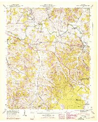
 1949 Fosterville1980 Print · USGSRutherford and Bedford Counties are captured in the late 1940s just as infrastructure was modernizing along the Tennessee Valley Divide. Researchers can trace family roots through numerous landmarks like Guy Gap Sch, Alexander Cem, and Brandon Chapel.2 unique versions available
End of results
Showing maps 1-17 of 17
Top cities of Bedford County
- Shelbyville historical maps
- Wartrace historical maps
- Bell Buckle historical maps
- Normandy historical maps
Frequently asked questions
- What are the different types of historical maps available for Bedford County?
- What is the oldest map of Bedford County?
- Where can I purchase historical maps of Bedford County for my home or office?
- Where can I download high-res historical maps of Bedford County?
- Are there historical topographic maps available for Bedford County?
- Is there historical aerial imagery available for Bedford County?
- Where are historical maps of Bedford County sourced from?