1950s Maps of Blount County, Tennessee
Explore 18 historic maps of Blount County from the 1950s. These maps offer a rare glimpse into what life looked like during the 1950s — showing old roads, neighborhoods, homes, and landmarks that have changed or disappeared over time.
Whether you're researching your family's past, planning a metal detecting trip, or studying how Blount County's landscape evolved across the 1950s, these high-resolution maps are a powerful tool for exploring the history of this region.
- Focus on a specific era: All maps on this page are from the 1950s, giving you a focused view of this time period.
- See what’s changed: Compare century-old streets, trails, and buildings to today's modern landscape using overlays and satellite layers.
- Research with precision: Use these maps for genealogy, historical research, land use analysis, or educational projects.
- View, download, or print: Maps are fully viewable online in high resolution, and can be downloaded or printed for your own records.
Start exploring Blount County's history through authentic maps from the 1950s. This is your window into the past.
Blount County, TN maps
(18)- 1952 Map of Meadow, 1954 Print
 1952 Meadow1954 Print · USGSThe river valleys of East Tennessee are captured here in the early fifties, showing a landscape defined by ferry crossings and hilltop family cemeteries. Trace historic sites like the National Camp Ground, the settlement of Morganton, and the LOUISVILLE AND NASHVILLE rail line.3 unique versions available
 - 1952 Map of Binfield, 1954 Print
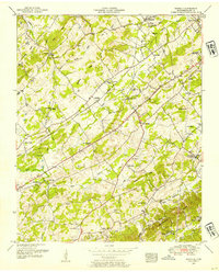 1952 Binfield1954 Print · USGSBlount County in the early fifties is captured here as a landscape of rural community centers and family farms along the Louisville and Nashville railroad. Genealogists and local historians can locate dozens of landmarks including Brick Mill, Carpenter Campground, and the Seceder Cemetery.4 unique versions available
 - 1953 Map of Chattanooga
 1953 Chattanooga1953 Print · USGSSoutheast Tennessee in the early fifties shows a landscape reshaped by river management and rail power. Trace the rail lines of the Southern Ry through riverside towns or locate the preserved grounds of the Chickamauga and Chattanooga National Military Park.
 - 1953 Map of Wear Cove, 1954 Print
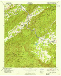
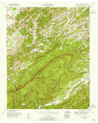
 1953 Wear Cove1954 Print · USGSThe coves and ridges of Blount and Sevier Counties are captured here just as the national park era was maturing. Genealogists and hikers can trace old family sites like Hatchertown, find the Park Settlement School, and locate The Sinks along the Little River.2 unique versions available
 - 1953 Map of Shooks Gap, 1954 Print
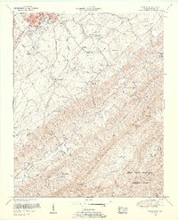
 1953 Shooks Gap1954 Print · USGSEast of Knoxville in the early fifties, the landscape was a mix of river-bottom farms and rising suburban development. Genealogists can find family landmarks like McCammon Cemetery, industrial sites at Meades Quarry, and the historic Riverdale Ferry crossing.3 unique versions available
 - 1953 Map of Knoxville, 1955 Print
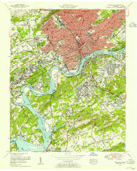 1953 Knoxville1955 Print · USGSKnoxville's mid-century skyline and riverfront are meticulously documented here just as the city's modern footprint was taking shape. Genealogists and local historians can trace the foundations of Knoxville College, the bustling Coster Yards, and family plots in National Cemetery.2 unique versions available
 - 1953 Map of Bearden, 1955 Print
 1953 Bearden1955 Print · USGSWest of Knoxville in the early fifties, this area shows a landscape transitioning from rural ridges to suburban communities. Trace family roots at Mars Hill Cemetery, the Blue Grass School, or along the busy tracks of the Louisville and Nashville railroad.
 - 1953 Map of Wildwood, 1955 Print
 1953 Wildwood1955 Print · USGSIn the mid-1950s, this portion of Blount County shows a landscape of family farms and mountain ridges along the Little River. Genealogists can trace family names at Headrick Cemetery and McCampbell Cemetery or locate community centers like Eusebia Church and the Klondike School.5 unique versions available
 - 1953 Map of Blockhouse, 1955 Print
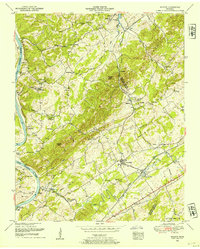
 1953 Blockhouse1955 Print · USGSBlount County at the edge of the Smokies comes into focus in this mid-century survey as the suburbs of Maryville meet the mountain gaps. Genealogists can trace family sites at Grandview Cemetery, the settlement of Blockhouse, and Sam Houston School.2 unique versions available
 - 1953 Map of Kinzel Springs, 1955 Print
 1953 Kinzel Springs1955 Print · USGSBlount County at the edge of the Smokies comes alive in the early fifties as the valley floor meets the mountain ridges. Researchers can locate vanished rural institutions and early transport lines like the Little River RR, Laws School, and Kinzel Springs.5 unique versions available
 - 1953 Map of Louisville, 1955 Print
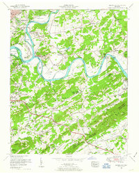
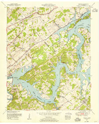
 1953 Louisville1955 Print · USGSBlount and Knox counties meet along the sprawling waters of the Tennessee River in the early fifties. Genealogists can trace family names at Louisville Cemetery and Jones Cemetery or find old rail stops at Miser Station and Pumpkin Center.
 - 1953 Map of Maryville, 1955 Print
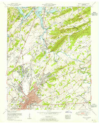 1953 Maryville1955 Print · USGSBlount County undergoes rapid change in the early fifties as industry and aviation reshape the landscape near the Tennessee River. Genealogists can locate family names at Harris Cemetery, study Maryville College, or trace the rail lines through Rockford and Alcoa.2 unique versions available
 - 1953 Map of Walden Creek, 1955 Print
 1953 Walden Creek1955 Print · USGSSevier County in the early fifties shows a landscape of deep hollows and high ridges before the era of modern development. Genealogists can trace family roots through numerous mountain churches and schools like Antioch Church, Benson School, and Ivy Hill Cemetery.4 unique versions available
 - 1953 Map of Concord, 1955 Print
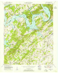
 1953 Concord1955 Print · USGSEast Tennessee's river valleys were undergoing a profound transformation in the early fifties as new reservoirs reshaped the landscape. Researchers can trace the flooded bends of the Tennessee River, locate family sites like Leeper Cemetery, and explore crossroads like Dixie Lee Junction or the rail town of Concord.3 unique versions available
 - 1955 Map of Knoxville
 1955 Knoxville1955 Print · USGSThe Southern Appalachians and the Smoky Mountains are shown here at a peak of mid-century development and conservation. Genealogists and historians can trace the early road networks connecting Gatlinburg, Waynesville, and the Cherokee Indian Reservation across the high ridges.
 - 1957 Map of Knoxville, 1966 Print
 1957 Knoxville1966 Print · USGSThe Southern Appalachians of Tennessee and North Carolina are mapped here during the mid-twentieth century as new highways reached the high country. Genealogists and historians can trace the topography between Knoxville and Asheville, locating family landmarks near Fontana Lake or along the Blue Ridge Parkway.4 unique versions available
 - 1957 Map of Chattanooga, 1966 Print
 1957 Chattanooga1966 Print · USGSEast Tennessee in the mid-1960s shows a landscape of massive hydroelectric reservoirs and emerging industrial sites like the Atomic Energy Commission (Oak Ridge Area). Trace the rail networks of the Southern Ry through Chattanooga or locate family-named ridges across the Cumberland Plateau.3 unique versions available
 - 1959 Map of Chattanooga
 1959 Chattanooga1959 Print · USGSSoutheast Tennessee is shown here during a decade of industrial growth and hydroelectric development. Trace the regional rail networks of the Southern Ry and find landmark sites like Lookout Mountain, Fall Creek Falls State Park, and Chattanooga.
End of results
Showing maps 1-18 of 18
Top cities of Blount County
- Maryville historical maps
- Alcoa historical maps
- Louisville historical maps
- Friendsville historical maps
- Rockford historical maps
- Townsend historical maps
Frequently asked questions
- What are the different types of historical maps available for Blount County?
- What is the oldest map of Blount County?
- Where can I purchase historical maps of Blount County for my home or office?
- Where can I download high-res historical maps of Blount County?
- Are there historical topographic maps available for Blount County?
- Is there historical aerial imagery available for Blount County?
- Where are historical maps of Blount County sourced from?