1960s Maps of Bradley County, Tennessee
Explore 16 historic maps of Bradley County from the 1960s. These maps offer a rare glimpse into what life looked like during the 1960s — showing old roads, neighborhoods, homes, and landmarks that have changed or disappeared over time.
Whether you're researching your family's past, planning a metal detecting trip, or studying how Bradley County's landscape evolved across the 1960s, these high-resolution maps are a powerful tool for exploring the history of this region.
- Focus on a specific era: All maps on this page are from the 1960s, giving you a focused view of this time period.
- See what’s changed: Compare century-old streets, trails, and buildings to today's modern landscape using overlays and satellite layers.
- Research with precision: Use these maps for genealogy, historical research, land use analysis, or educational projects.
- View, download, or print: Maps are fully viewable online in high resolution, and can be downloaded or printed for your own records.
Start exploring Bradley County's history through authentic maps from the 1960s. This is your window into the past.
Bradley County, TN maps
(16)- 1960 Map of Chattanooga
 1960 Chattanooga1960 Print · USGSSoutheast Tennessee and the southern Appalachians are shown here at the height of the river-management era. You can trace the valley rail lines and locate Lookout Mountain and the expansive waters of Chickamauga Reservoir.
 - 1960 Map of Cohutta, 1962 Print
 1960 Cohutta1962 Print · USGSWhitfield County and the Georgia-Tennessee border are detailed here in the early sixties, showing a landscape of forest ridges and rail-side towns. Genealogists can locate family landmarks like Prater Mill, South Cohutta Ch, and the Hoskins Cem.3 unique versions available
 - 1961 Map of Rome
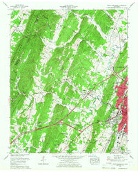
 1961 Rome1961 Print · USGSNorthwest Georgia and neighboring Tennessee and Alabama are shown here at a moment of significant mid-century growth. Researchers can trace the rail networks of the Central of Georgia or locate landmarks within Chickamauga and Chattanooga Nat Military Park.
 - 1963 Map of Rome
 1963 Rome1963 Print · USGSThe tri-state corner of Georgia, Alabama, and Tennessee is captured here during a period of massive reservoir expansion and post-war growth. Genealogists and historians can trace the rail corridors of the Southern Ry or locate landmarks like Fort Oglethorpe and Cloudland Canyon State Park.
 - 1964 Map of Chattanooga
 1964 Chattanooga1964 Print · USGSSoutheast Tennessee and the western Carolinas appear in the mid-sixties as a powerhouse of river-driven industry and mountain wilderness. Genealogists and historians can trace rail-town lineages along the Southern Ry or locate family landmarks near Watts Bar Lake and Tellico Plains.
 - 1964 Map of Snow Hill, 1966 Print
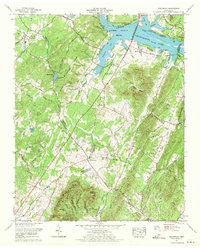
 1964 Snow Hill1966 Print · USGSHamilton County in the mid-sixties reveals a landscape transformed by the Tennessee River and the growth of recreational spaces. Researchers can trace family history through numerous rural burial sites like Roddy-Yarnell Cem and landmarks such as the Wolftever Fishing Club or Jones Airfield.2 unique versions available
 - 1964 Map of Calhoun, 1966 Print
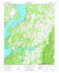
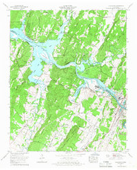
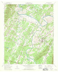
 1964 Calhoun1966 Print · USGSThe Hiwassee River valley at the height of the sixties serves as a vital rail and river corridor for Charleston and Calhoun. Genealogists can trace family landmarks across the ridges, including Old Swafford Cem, Walnut Grove Ch, and Waldrop Store.2 unique versions available
 - 1964 Map of Ooltewah, 1966 Print
 1964 Ooltewah1966 Print · USGSHamilton County in the mid-sixties reveals a landscape balancing its military history with growing educational and rail hubs. Researchers can trace family-named cemeteries such as Sylar Cemetery and Plowman Cemetery or locate landmarks like Bell Mill and the Southern Missionary College.4 unique versions available
 - 1965 Map of South Cleveland, 1966 Print
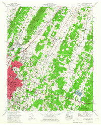
 1965 South Cleveland1966 Print · USGSSoutheast Tennessee is captured here in the mid-sixties as the suburbs of Cleveland began to reach toward White Oak Mountain. Researchers can trace family history through sites like Seaborn Cem, Hopewell Sch, and the Bachman Memorial Childrens Home.2 unique versions available
 - 1965 Map of Charleston, 1966 Print
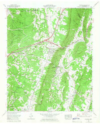
 1965 Charleston1966 Print · USGSThe riverfront communities of Charleston and Calhoun are shown during a period of industrial growth along the Hiwassee in the mid-sixties. Genealogists and local historians can trace family sites like Skelton Memorial Cem, Bethel Springs, and the old Grays Ferry crossing.2 unique versions available
 - 1965 Map of East Cleveland, 1966 Print
 1965 East Cleveland1966 Print · USGSMid-century development in the Tennessee Valley sees the growth of Cleveland alongside its historic rural corridors. Genealogists and historians can trace family roots through numerous sites like Belle Founte Ch, Pirkle Cem, and the old Hays Mill.
 - 1966 Map of Parksville, 1970 Print
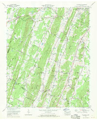
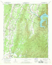 1966 Parksville1970 Print · USGSSoutheast Tennessee is shown in the mid-1960s as a landscape of mountain ridges, river engineering, and timbered national forest. Genealogists can trace family roots at Old Fort Cem or Ball Play Ch Cem and locate rail stops like Oldfort and Conasauga.3 unique versions available
 - 1967 Map of Birchwood, 1970 Print
 1967 Birchwood1970 Print · USGSThe Tennessee Valley in the late 1960s shows a landscape defined by the ridges of White Oak Mountain and the rising waters of Chickamauga Lake. Genealogists can trace family names at Hinkle Cemetery and Francisco Cem or locate the old Meadowview Sch.
 - 1967 Map of Benton, 1970 Print
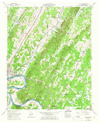
 1967 Benton1970 Print · USGSBenton and the surrounding river bottoms are captured here in the late sixties, showing a landscape defined by the Tennessee Valley Authority’s influence. Trace local history through the Nancy Ward Cem, the Old Federal Road, and rural stops like Benton Station.3 unique versions available
 - 1967 Map of Felker, 1970 Print
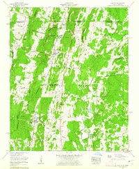
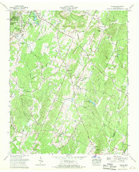 1967 Felker1970 Print · USGSBradley County's rural uplands are shown in the late sixties, before modern development altered the local road network. Genealogists can locate family landmarks like McClure Cem, Swan Cem, and churches including Boanerges Ch and New Hope Ch.3 unique versions available
 - 1967 Map of Mc Donald, 1970 Print
 1967 Mc Donald1970 Print · USGSBradley and Hamilton counties during the late sixties are captured here in meticulous detail, showing the rural communities between the ridges. Researchers can trace family sites near McDonald, Bethel Ch, and the Lee Cem while following old railroad spurs at Marble Switch.3 unique versions available
End of results
Showing maps 1-16 of 16
Top cities of Bradley County
Frequently asked questions
- What are the different types of historical maps available for Bradley County?
- What is the oldest map of Bradley County?
- Where can I purchase historical maps of Bradley County for my home or office?
- Where can I download high-res historical maps of Bradley County?
- Are there historical topographic maps available for Bradley County?
- Is there historical aerial imagery available for Bradley County?
- Where are historical maps of Bradley County sourced from?