1970s Maps of Bradley County, Tennessee
Explore 3 historic maps of Bradley County from the 1970s. These maps offer a rare glimpse into what life looked like during the 1970s — showing old roads, neighborhoods, homes, and landmarks that have changed or disappeared over time.
Whether you're researching your family's past, planning a metal detecting trip, or studying how Bradley County's landscape evolved across the 1970s, these high-resolution maps are a powerful tool for exploring the history of this region.
- Focus on a specific era: All maps on this page are from the 1970s, giving you a focused view of this time period.
- See what’s changed: Compare century-old streets, trails, and buildings to today's modern landscape using overlays and satellite layers.
- Research with precision: Use these maps for genealogy, historical research, land use analysis, or educational projects.
- View, download, or print: Maps are fully viewable online in high resolution, and can be downloaded or printed for your own records.
Start exploring Bradley County's history through authentic maps from the 1970s. This is your window into the past.
Bradley County, TN maps
(3)- 1972 Map of Beaverdale, 1974 Print
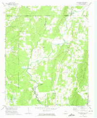 1972 Beaverdale1974 Print · USGSThe Georgia-Tennessee border region comes to life in the early seventies, centered on the winding Conasauga River. Genealogists and historians can trace family roots through several rural landmarks, including Gregory's Mill, Mt Pleasant Cemetery, and the Dalton Childrens Home.
 - 1976 Map of East Cleveland, 1977 Print
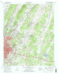 1976 East Cleveland1977 Print · USGSThe Bradley County suburbs and the Southern Railway corridor near Cleveland are captured in the mid-1970s during a period of modern expansion. Researchers can trace the development of older communities like Tasso and locate family landmarks such as Ramsey Cem or Michigan Avenue Sch.
 - 1979 Map of Chattanooga, 1980 Print
 1979 Chattanooga1980 Print · USGSSoutheast Tennessee in the late seventies reveals a landscape shaped by massive TVA river projects and the industrial strength of the Cumberland Plateau. Genealogists and historians can trace the rail-to-river network through L & N RR junctions, the University of the South, and the Volunteer Army Ammunition Plant.
End of results
Showing maps 1-3 of 3
Top cities of Bradley County
Frequently asked questions
- What are the different types of historical maps available for Bradley County?
- What is the oldest map of Bradley County?
- Where can I purchase historical maps of Bradley County for my home or office?
- Where can I download high-res historical maps of Bradley County?
- Are there historical topographic maps available for Bradley County?
- Is there historical aerial imagery available for Bradley County?
- Where are historical maps of Bradley County sourced from?