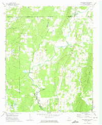
1972 Map of Beaverdale
USGS Topo · Published 1974About this map
The Conasauga River winds through the heart of the Georgia-Tennessee borderlands, defining the boundary between Murray and Whitfield counties. In the early 1970s, this landscape was a mix of valley bottomlands and the rising timber of the Chattahoochee National Forest. Small agricultural communities like Beaverdale and Sumac anchor the local geography, connected by a network of rural roads and a Jeep Trail cutting through the forest. The presence of Gregorys Mill along the river highlights the historical reliance on water power in this region, while institutions like the Dalton Childrens Home and Northwest School reflect the area's mid-century social development. Numerous country churches, including Fraziers Chapel and Sumach-Cumberland Church, serve as focal points for local genealogy research, marking the historic centers of these rural neighborhoods.
Find a feature on this map
46 named features on this map. Tap any name to fly to it.
Don’t see what you’re looking for? This feature index may not catch every label — zoom into the map to look around manually.
Map Details
Editions of this 1972 Beaverdale Map
This is the sole edition of this map. No revisions or reprints were ever made.
Other maps of this area

1886 · Dalton
USGS Topo · 1:125,000

1886 · Cleveland
USGS Topo · 1:125,000

1892 · Cleveland
USGS Topo · 1:125,000

1892 · Dalton
USGS Topo · 1:125,000

1895 · Cleveland
USGS Topo · 1:125,000

1897 · Dalton
USGS Topo · 1:125,000

1901 · Cleveland
USGS Topo · 1:125,000

1911 · Cohutta Mtn
USGS Topo · 1:62,500

1913 · Cohutta Mtn.
USGS Topo · 1:62,500

1935 · Mc Donald
USGS Topo · 1:24,000