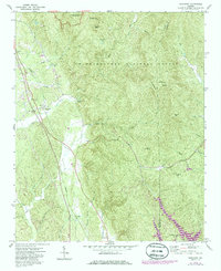
1971 Map of Ramhurst
USGS Topo · Published 1986About this map
Ramhurst stands at the western edge of the mountain front, where the Seaboard railroad follows the valley floor below the high ridges of the Chattahoochee National Forest. This 1971 survey captures the area as the Carters Lake reservoir was being established to the southeast, altering the local hydrology near Bloodtown and Coniston. The landscape is a mix of small settlements and rugged terrain, featuring peaks like Chestnut Knob and Cold Spring Mtn that rise over the watershed of Sugar Creek and Little Sugar Creek. Local history is preserved in the placement of several country churches and family landmarks, including Mt Pisgah Ch, Mt Zion Ch, and the Ramsey Cem. The presence of several Mines and a singular Mine near the northern boundary indicates the region's extraction history, while Fort Mountain State Park marks the transition into protected recreational lands.
Find a feature on this map
36 named features on this map. Tap any name to fly to it.
Don’t see what you’re looking for? This feature index may not catch every label — zoom into the map to look around manually.
Map Details
Editions of this 1971 Ramhurst Map
2 editions found
Other maps of this area

1886 · Dalton
USGS Topo · 1:125,000

1892 · Dalton
USGS Topo · 1:125,000

1897 · Dalton
USGS Topo · 1:125,000

1911 · Cohutta Mtn
USGS Topo · 1:62,500

1913 · Cohutta Mtn.
USGS Topo · 1:62,500

1914 · Talking Rock
USGS Topo · 1:62,500

1916 · Talking Rock
USGS Topo · 1:62,500

1938 · Chatsworth
USGS Topo · 1:48,000

1943 · Dalton
USGS Topo · 1:62,500
1949 · Calhoun
USGS Topo · 1:62,500